

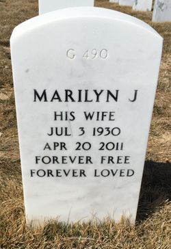

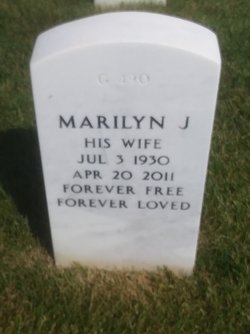
Marilyn J. Bodenner Furman-Smith
| Birth | : | 3 Jul 1930 Rapid City, Pennington County, South Dakota, USA |
| Death | : | 20 Apr 2011 Miles City, Custer County, Montana, USA |
| Burial | : | Black Hills National Cemetery, Sturgis, Meade County, USA |
| Coordinate | : | 44.3689003, -103.4753036 |
| Plot | : | SECTION G SITE 490 |
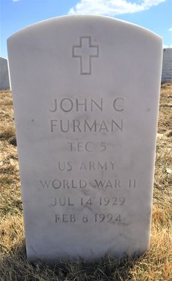
| Inscription | : | WIFE OF FURMAN, JOHN CHARLES TEC5 US ARMY |
| Description | : | Marilyn Furman-Smith, age 80, passed away on Wednesday, April 20, 2011 at her daughter's and son in law's home . Marilyn was born on July 3, 1930 in Rapid City, South Dakota to parents William Fauss Bodenner and Inga Sanner. She grew up in Fairburn, South Dakota and attended school through the 10th grade in Fairburn. She then commuted by train to Rapid City, where she graduated from high school. She worked in the area until her marriage to John "Jack" Charles Furman on July 23, 1953 in Rapid City. The couple lived... Read More |
frequently asked questions (FAQ):
-
Where is Marilyn J. Bodenner Furman-Smith's memorial?
Marilyn J. Bodenner Furman-Smith's memorial is located at: Black Hills National Cemetery, Sturgis, Meade County, USA.
-
When did Marilyn J. Bodenner Furman-Smith death?
Marilyn J. Bodenner Furman-Smith death on 20 Apr 2011 in Miles City, Custer County, Montana, USA
-
Where are the coordinates of the Marilyn J. Bodenner Furman-Smith's memorial?
Latitude: 44.3689003
Longitude: -103.4753036
Family Members:
Spouse
Flowers:


Nearby Cemetories:
1. Black Hills National Cemetery
Sturgis, Meade County, USA
Coordinate: 44.3689003, -103.4753036
2. Curley Grimes Memorial Cemetery
Sturgis, Meade County, USA
Coordinate: 44.3764500, -103.4691300
3. Fort Meade National Cemetery
Sturgis, Meade County, USA
Coordinate: 44.4021988, -103.4757996
4. Bear Butte Cemetery
Sturgis, Meade County, USA
Coordinate: 44.4111595, -103.4947968
5. Saint Aloysius Cemetery
Sturgis, Meade County, USA
Coordinate: 44.4141340, -103.5193420
6. Pleasant Valley Cemetery
Tilford, Meade County, USA
Coordinate: 44.3192500, -103.3531160
7. Galena Cemetery
Galena, Lawrence County, USA
Coordinate: 44.3349220, -103.6438410
8. Crook City Cemetery
Crook City, Lawrence County, USA
Coordinate: 44.4432100, -103.6241500
9. Piedmont Cemetery
Piedmont, Meade County, USA
Coordinate: 44.2425780, -103.3871730
10. Oak Ridge Cemetery
Deadwood, Lawrence County, USA
Coordinate: 44.3891983, -103.6766968
11. Whitewood Cemetery
Whitewood, Lawrence County, USA
Coordinate: 44.4617820, -103.6330030
12. Roubaix Cemetery
Roubaix, Lawrence County, USA
Coordinate: 44.2789380, -103.6656600
13. Mount Moriah Cemetery
Deadwood, Lawrence County, USA
Coordinate: 44.3760986, -103.7253036
14. Saint Ambrose Cemetery
Deadwood, Lawrence County, USA
Coordinate: 44.3821983, -103.7266998
15. Nemo Cemetery
Nemo, Lawrence County, USA
Coordinate: 44.1872800, -103.5066410
16. Anderson Cemetery
Lawrence County, USA
Coordinate: 44.4747009, -103.6896973
17. South Lead Cemetery
Lead, Lawrence County, USA
Coordinate: 44.3478510, -103.7606260
18. Little Dane Cemetery
Saint Onge, Lawrence County, USA
Coordinate: 44.5252500, -103.6705540
19. Mountain Meadow Cemetery
Lawrence County, USA
Coordinate: 44.2038994, -103.6557999
20. West Lead Cemetery
Lead, Lawrence County, USA
Coordinate: 44.3484001, -103.7779999
21. Gate of Heaven Cemetery
Saint Onge, Lawrence County, USA
Coordinate: 44.5353000, -103.7237000
22. Terry Cemetery
Terry, Lawrence County, USA
Coordinate: 44.3344290, -103.8165110
23. Vale Cemetery
Vale, Butte County, USA
Coordinate: 44.6138992, -103.4052963
24. Holy Cross Cemetery
Englewood, Lawrence County, USA
Coordinate: 44.2818985, -103.8047028