
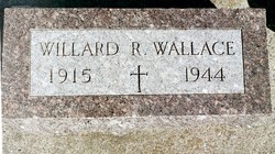
| Birth | : | 24 Aug 1914 Andrew, Jackson County, Iowa, USA |
| Death | : | 4 Mar 2007 Maquoketa, Jackson County, Iowa, USA |
| Burial | : | Duke Street Cemetery, Southport, Metropolitan Borough of Sefton, England |
| Coordinate | : | 53.6343536, -2.9993131 |
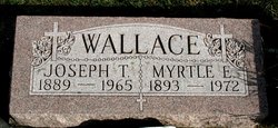
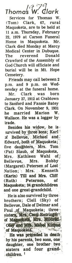
| Description | : | Marion W. Clark, 92, of Maquoketa Iowa died Sunday morning, March 4, 2007 at the Jackson County Reginal Health Center in Maquoketa. A celebration of her life was held at 11:30 a.m. Wednesday, March 7, 2007, at Sacred Heart Catholic Church in Maquoketa, with Rev. James Chappell and Deacon Robert Head officiating. Cremation rites were accorded. Burial was in Mt. Hope Cemetery, Maquoketa Marion W. Wallace Clark was born August 24, 1914 near Andrew to Joseph & Myrtle Edwards Wallace. She was a Maquoketa Community High School Graduate. |
frequently asked questions (FAQ):
-
Where is Marion Frances Wallace Clark's memorial?
Marion Frances Wallace Clark's memorial is located at: Duke Street Cemetery, Southport, Metropolitan Borough of Sefton, England.
-
When did Marion Frances Wallace Clark death?
Marion Frances Wallace Clark death on 4 Mar 2007 in Maquoketa, Jackson County, Iowa, USA
-
Where are the coordinates of the Marion Frances Wallace Clark's memorial?
Latitude: 53.6343536
Longitude: -2.9993131
Family Members:
Parent
Spouse
Siblings

Children
Flowers:


Nearby Cemetories:
1. Duke Street Cemetery
Southport, Metropolitan Borough of Sefton, England
Coordinate: 53.6343536, -2.9993131
2. Christ Church Churchyard
Southport, Metropolitan Borough of Sefton, England
Coordinate: 53.6327778, -2.9953770
3. Ardwick Cemetery
Ardwick, Metropolitan Borough of Manchester, England
Coordinate: 53.6302778, -2.9900000
4. Holy Trinity Church
Southport, Metropolitan Borough of Sefton, England
Coordinate: 53.6503800, -2.9969150
5. St. Marie on the Sands
Southport, Metropolitan Borough of Sefton, England
Coordinate: 53.6524320, -3.0023440
6. Southport Crematorium
Scarisbrick, West Lancashire District, England
Coordinate: 53.6235810, -2.9600210
7. Emmanuel Parish Church
Southport, Metropolitan Borough of Sefton, England
Coordinate: 53.6604534, -2.9748117
8. Emmanuel Church Garden of Remembrance
North Meols, West Lancashire District, England
Coordinate: 53.6607130, -2.9753420
9. Liverpool Road Cemetery
Birkdale, Metropolitan Borough of Sefton, England
Coordinate: 53.6083620, -3.0257140
10. Sacred Heart RC Cemetery
Birkdale, Metropolitan Borough of Sefton, England
Coordinate: 53.6066100, -3.0270100
11. St Cuthberts Churchyard
Southport, Metropolitan Borough of Sefton, England
Coordinate: 53.6603230, -2.9620310
12. St. Mark Churchyard
Scarisbrick, West Lancashire District, England
Coordinate: 53.6134600, -2.9403800
13. Saint John Crossens Churchyard
Crossens, Metropolitan Borough of Sefton, England
Coordinate: 53.6733410, -2.9478740
14. St. Elizabeth's Churchyard
Scarisbrick, West Lancashire District, England
Coordinate: 53.6124460, -2.9206340
15. St. Cuthbert's Churchyard
Halsall, West Lancashire District, England
Coordinate: 53.5852140, -2.9529650
16. St. Stephen's Churchyard
North Meols, West Lancashire District, England
Coordinate: 53.6813720, -2.9248140
17. St. Peter's Churchyard
Formby, Metropolitan Borough of Sefton, England
Coordinate: 53.5663834, -3.0594721
18. West Lancashire Cemetery and Crematorium
Burscough, West Lancashire District, England
Coordinate: 53.5875500, -2.8820300
19. Our Lady Of Compassion RC Churchyard
Formby, Metropolitan Borough of Sefton, England
Coordinate: 53.5574060, -3.0575020
20. St. Michael and All Angels Churchyard
Great Altcar, Metropolitan Borough of Sefton, England
Coordinate: 53.5507770, -3.0279540
21. St Thomas Churchyard
Lydiate, Metropolitan Borough of Sefton, England
Coordinate: 53.5443480, -2.9621640
22. St Peter and St Paul Churchyard
Ormskirk, West Lancashire District, England
Coordinate: 53.5692640, -2.8877690
23. Christ Churchyard
Aughton, West Lancashire District, England
Coordinate: 53.5583510, -2.9046990
24. Saint Anne's Roman Catholic Church Cemetery
Ormskirk, West Lancashire District, England
Coordinate: 53.5626520, -2.8935560