
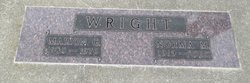
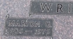
Marion Gustavus Wright
| Birth | : | 19 Oct 1905 East Lincoln Township, Mitchell County, Iowa, USA |
| Death | : | 4 Dec 1976 Mitchell County, Iowa, USA |
| Burial | : | Osage Cemetery, Osage, Mitchell County, USA |
| Coordinate | : | 43.2916700, -92.8201700 |
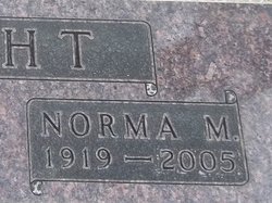
| Description | : | Funeral rites for an Osage resident, Marion Wright, 71, who died Dec. 4, (1976) at Mitchell County Memorial hospital, were held Tuesday afternoon at the Champion Funeral Home. Cause of his death was a heart condition. The Rev. Paul Metzger, pastor of the Rock Creek Lutheran church was in charge of the rites and burial was in the Osage cemetery. Marion Gustavus Wright was born near Orchard Oct. 19, 1905, the son of Benjamin and Rilla Elliott Wright. He grew to manhood on the family farm and attended the Stillwater school. Norma Brandt and Marion Wright were united in marriage April 30, 1940. They farmed in the... Read More |
frequently asked questions (FAQ):
-
Where is Marion Gustavus Wright's memorial?
Marion Gustavus Wright's memorial is located at: Osage Cemetery, Osage, Mitchell County, USA.
-
When did Marion Gustavus Wright death?
Marion Gustavus Wright death on 4 Dec 1976 in Mitchell County, Iowa, USA
-
Where are the coordinates of the Marion Gustavus Wright's memorial?
Latitude: 43.2916700
Longitude: -92.8201700
Family Members:
Parent

Spouse

Siblings
Flowers:


Nearby Cemetories:
1. Osage Cemetery
Osage, Mitchell County, USA
Coordinate: 43.2916700, -92.8201700
2. Sacred Heart Cemetery
Osage, Mitchell County, USA
Coordinate: 43.2742004, -92.7917023
3. South Osage Mennonite Church Cemetery
Osage, Mitchell County, USA
Coordinate: 43.2544556, -92.7915573
4. Tucker Cemetery
Osage, Mitchell County, USA
Coordinate: 43.2494011, -92.8319016
5. Oak Grove Cemetery
Mitchell, Mitchell County, USA
Coordinate: 43.3156013, -92.8707962
6. Calvary Cemetery
Osage, Mitchell County, USA
Coordinate: 43.2238998, -92.8300018
7. Orchard Cemetery
Orchard, Mitchell County, USA
Coordinate: 43.2249985, -92.7838898
8. Dudley Cemetery
Dudley (historical), Mitchell County, USA
Coordinate: 43.2252998, -92.8743973
9. Riverview Cemetery
Saint Ansgar, Mitchell County, USA
Coordinate: 43.3430328, -92.9220200
10. Rock Creek Cemetery
Meroa, Mitchell County, USA
Coordinate: 43.2352791, -92.9225006
11. Eden Presbyterian Cemetery
Meroa, Mitchell County, USA
Coordinate: 43.2131004, -92.9103012
12. West End Cemetery
Meroa, Mitchell County, USA
Coordinate: 43.2216682, -92.9250031
13. Saint Ansgar Cemetery
Saint Ansgar, Mitchell County, USA
Coordinate: 43.3777809, -92.9094391
14. Immanuel Lutheran Cemetery
Saint Ansgar, Mitchell County, USA
Coordinate: 43.3717003, -92.9257965
15. First Lutheran Cemetery
Saint Ansgar, Mitchell County, USA
Coordinate: 43.3841705, -92.9194412
16. Liberty Cemetery
Little Cedar, Mitchell County, USA
Coordinate: 43.3856010, -92.7230988
17. Beaver Creek Cemetery
Brownville, Mitchell County, USA
Coordinate: 43.3397217, -92.6727829
18. Blakestad Cemetery
Saint Ansgar, Mitchell County, USA
Coordinate: 43.3711014, -92.9400024
19. Saint Johns Lutheran Cemetery
Rock Creek, Mitchell County, USA
Coordinate: 43.3295560, -92.9849770
20. Saint Peters Cemetery
New Haven, Mitchell County, USA
Coordinate: 43.2858315, -92.6427765
21. Saint Johns Lutheran Old Cemetery
Rock Creek, Mitchell County, USA
Coordinate: 43.3313904, -92.9897232
22. Stillwater Cemetery
Orchard, Mitchell County, USA
Coordinate: 43.2130585, -92.6780624
23. McKinley Cemetery
Saint Ansgar, Mitchell County, USA
Coordinate: 43.3906400, -92.9368300
24. Howardville Cemetery
Floyd, Floyd County, USA
Coordinate: 43.1866989, -92.7016983