

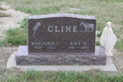
Marjorie Joan Strait Cline
| Birth | : | 14 Oct 1926 Ekalaka, Carter County, Montana, USA |
| Death | : | 22 Dec 2002 Miles City, Custer County, Montana, USA |
| Burial | : | Beaver Lodge Cemetery, Ekalaka, Carter County, USA |
| Coordinate | : | 45.8847008, -104.5522003 |
| Description | : | Marjorie Joan Cline, age 76, of Miles City formerly of Ekalaka passed away Sunday, December 22, 2002 at home surrounded by her loving family after a courageous battle with cancer. Marjorie Joan Strait was born in 1926 to James Duane and Lulu Rafinberic Strait. She attended country school, Plevna School, and later moved to Ekalaka where she attended high school. While in Ekalaka, she met her first husband Robert George Metzenberg. He was killed on the Philippine Islands during World War II. One child, Georgie Joan Metzenberg, was born to this union. She then married Gene Loehding. They later divorced.... Read More |
frequently asked questions (FAQ):
-
Where is Marjorie Joan Strait Cline's memorial?
Marjorie Joan Strait Cline's memorial is located at: Beaver Lodge Cemetery, Ekalaka, Carter County, USA.
-
When did Marjorie Joan Strait Cline death?
Marjorie Joan Strait Cline death on 22 Dec 2002 in Miles City, Custer County, Montana, USA
-
Where are the coordinates of the Marjorie Joan Strait Cline's memorial?
Latitude: 45.8847008
Longitude: -104.5522003
Family Members:
Spouse
Children

Flowers:


Nearby Cemetories:
1. Beaver Lodge Cemetery
Ekalaka, Carter County, USA
Coordinate: 45.8847008, -104.5522003
2. Russell Cemetery
Carter County, USA
Coordinate: 45.8292007, -104.4681015
3. Medicine Rock Church Cemetery
Ekalaka, Carter County, USA
Coordinate: 46.0545460, -104.4554010
4. Trenk Family Plot
Ekalaka, Carter County, USA
Coordinate: 45.7325000, -104.7083333
5. Willard Cemetery
Willard, Fallon County, USA
Coordinate: 46.1932000, -104.4123460
6. Lame Jones Cemetery
Plevna, Fallon County, USA
Coordinate: 46.2230988, -104.6181030
7. Ewalt Cemetery
Ridgeway, Carter County, USA
Coordinate: 45.4908333, -104.4786111
8. Pioneer Cemetery
Carter County, USA
Coordinate: 45.5859560, -104.1484850
9. Boothill Cemetery
Powder River County, USA
Coordinate: 45.7592010, -105.1239014
10. MacKenzie Family Cemetery
Custer County, USA
Coordinate: 46.1569500, -105.1448000
11. Saint John Cemetery
Baker, Fallon County, USA
Coordinate: 46.3563995, -104.2822037
12. Fairview Cemetery
Camp Crook, Harding County, USA
Coordinate: 45.5447006, -103.9972000
13. Saint Anthony Cemetery
Plevna, Fallon County, USA
Coordinate: 46.4042015, -104.5199966
14. Askin Family Cemetery
Fallon County, USA
Coordinate: 46.3806000, -104.2811000
15. Bonnievale Cemetery
Baker, Fallon County, USA
Coordinate: 46.3819008, -104.2791977
16. Peace Lutheran Cemetery
Plevna, Fallon County, USA
Coordinate: 46.4169006, -104.5294037
17. Community Union Cemetery
Plevna, Fallon County, USA
Coordinate: 46.4180984, -104.5289001
18. Alma Cemetery
Harding County, USA
Coordinate: 45.6469002, -103.8480988
19. Ladner Cemetery
Ladner, Harding County, USA
Coordinate: 45.8238983, -103.7694016
20. Fertile Prairie Cemetery
Fallon County, USA
Coordinate: 46.3396988, -104.0935974
21. Bringa Cemetery
Ladner, Harding County, USA
Coordinate: 45.7915570, -103.7575860
22. Knowlton Cemetery
Custer County, USA
Coordinate: 46.3210983, -105.0710983
23. Little Missouri Lutheran Cemetery
Carter County, USA
Coordinate: 45.4186000, -104.0820000
24. Capitol Cemetery
Capitol, Carter County, USA
Coordinate: 45.4294014, -104.0513992