
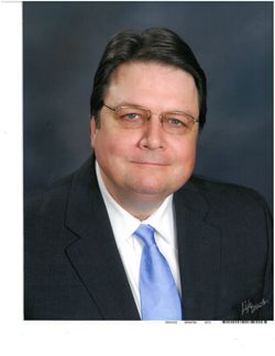
Mark Alan Neal
| Birth | : | 13 Nov 1957 |
| Death | : | 22 Aug 2018 |
| Burial | : | Gamble Cemetery, California, Moniteau County, USA |
| Coordinate | : | 38.5393982, -92.5757980 |
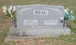
| Description | : | Mark Neal, 60, of Blue Springs, MO passed away August 22, 2018. Visitation will be 6-8 pm Monday, August 27, 2018 at Speaks Suburban Chapel. Graveside service will be 1 pm Tuesday, August 28, 2018 at Gamble Cemetery in California, MO. Mark was born on November 13, 1957 in Jefferson City, MO to Harley and Dorothy (Siebert) Neal. Mark earned his Bachelor’s Degree from UMKC as was a CPA and did consulting in the area. He enjoyed building computers and was a history buff. Mark was a member of Chapel Hill Presbyterian Church for many years. Survivors include bothers Mitchell... Read More |
frequently asked questions (FAQ):
-
Where is Mark Alan Neal's memorial?
Mark Alan Neal's memorial is located at: Gamble Cemetery, California, Moniteau County, USA.
-
When did Mark Alan Neal death?
Mark Alan Neal death on 22 Aug 2018 in
-
Where are the coordinates of the Mark Alan Neal's memorial?
Latitude: 38.5393982
Longitude: -92.5757980
Family Members:
Parent
Siblings
Flowers:


Nearby Cemetories:
1. Gamble Cemetery
California, Moniteau County, USA
Coordinate: 38.5393982, -92.5757980
2. Marney Family Cemetery
High Point, Moniteau County, USA
Coordinate: 38.5357900, -92.5614500
3. Old Latham Cemetery
Latham, Moniteau County, USA
Coordinate: 38.5466400, -92.5891100
4. Yarnell Cemetery
California, Moniteau County, USA
Coordinate: 38.5189018, -92.5708008
5. Union Christian Church Cemetery
High Point, Moniteau County, USA
Coordinate: 38.5196390, -92.5994260
6. Norman Cemetery
High Point, Moniteau County, USA
Coordinate: 38.5681700, -92.5691300
7. DeFoe Cemetery
California, Moniteau County, USA
Coordinate: 38.5416985, -92.5250015
8. Sappington Community Chapel Cemetery
California, Moniteau County, USA
Coordinate: 38.5770500, -92.6026700
9. United Baptist Church Cemetery
High Point, Moniteau County, USA
Coordinate: 38.4962200, -92.5856800
10. Karnes Cemetery
Corticelli, Moniteau County, USA
Coordinate: 38.5099700, -92.5247900
11. Elliott Cemetery
Moniteau County, USA
Coordinate: 38.5244500, -92.6408700
12. High Point Cemetery
High Point, Moniteau County, USA
Coordinate: 38.4817009, -92.5757980
13. Brown Family Cemetery
California, Moniteau County, USA
Coordinate: 38.5862100, -92.5308800
14. Depp Cemetery
High Point, Moniteau County, USA
Coordinate: 38.4776400, -92.5818500
15. Pleasant Hill Cemetery
Moniteau County, USA
Coordinate: 38.5329500, -92.6590800
16. Karnes-Carney-Henderson Cemetery
Burris Fork, Moniteau County, USA
Coordinate: 38.4992100, -92.5007510
17. Salem United Church of Christ Cemetery
Moniteau County, USA
Coordinate: 38.5864300, -92.5045400
18. McKissick Family Cemetery
California, Moniteau County, USA
Coordinate: 38.6124900, -92.5815400
19. Anderson Cemetery
Moniteau County, USA
Coordinate: 38.6130500, -92.5617700
20. Latham Cemetery
Latham, Moniteau County, USA
Coordinate: 38.5643997, -92.6680984
21. Flag Spring Cemetery
California, Moniteau County, USA
Coordinate: 38.6102900, -92.6187800
22. Boeckhaus Cemetery
California, Moniteau County, USA
Coordinate: 38.6225100, -92.5862700
23. Spring Hill Mennonite Cemetery
Latham, Moniteau County, USA
Coordinate: 38.5537900, -92.6824100
24. Hutchison-Houchin Family Cemetery
California, Moniteau County, USA
Coordinate: 38.6245900, -92.5821200