
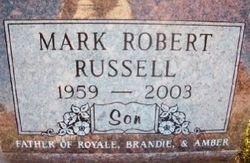
Mark Robert Russell
| Birth | : | 18 Feb 1959 Akron, Plymouth County, Iowa, USA |
| Death | : | 26 Oct 2003 Le Mars, Plymouth County, Iowa, USA |
| Burial | : | Abbey & St James' Graveyard for the Poor, Widcombe, Bath and North East Somerset Unitary Authority, England |
| Coordinate | : | 51.3753550, -2.3545640 |
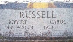
| Description | : | Mark Russell, 44 Mark Russell, of Le Mars, died Sunday, October 26, 2003, at his residence. Services were held Wednesday, October 29 at St. James Catholic Church in Le Mars, with the Rev. James Tigges officiating. Burial was in Calvary Cemetery. Pallbearers were Corey Frerichs, Mike Arens, Ben Gerritson, Tyler Small, Josh Hummel, Alan Hummel and B.J. Hummel. Carlsen Funeral Home in Le Mars was in charges of arrangements. Mark Robert Russell was born February 18, 1959, in Akron, to Robert and Carol (Lade) Russell. He grew up on a farm east of Akron... Read More |
frequently asked questions (FAQ):
-
Where is Mark Robert Russell's memorial?
Mark Robert Russell's memorial is located at: Abbey & St James' Graveyard for the Poor, Widcombe, Bath and North East Somerset Unitary Authority, England.
-
When did Mark Robert Russell death?
Mark Robert Russell death on 26 Oct 2003 in Le Mars, Plymouth County, Iowa, USA
-
Where are the coordinates of the Mark Robert Russell's memorial?
Latitude: 51.3753550
Longitude: -2.3545640
Family Members:
Parent
Spouse
Siblings
Flowers:


Nearby Cemetories:
1. Abbey & St James' Graveyard for the Poor
Widcombe, Bath and North East Somerset Unitary Authority, England
Coordinate: 51.3753550, -2.3545640
2. Old Baptist Burial Ground
Walcot, Bath and North East Somerset Unitary Authority, England
Coordinate: 51.3755070, -2.3544360
3. Baptist Burial Ground
Widcombe, Bath and North East Somerset Unitary Authority, England
Coordinate: 51.3764216, -2.3556947
4. Saint Mark's Churchyard
Widcombe, Bath and North East Somerset Unitary Authority, England
Coordinate: 51.3766660, -2.3588010
5. Quaker Burial Ground
Widcombe, Bath and North East Somerset Unitary Authority, England
Coordinate: 51.3744350, -2.3498460
6. Unitarian Chapel Burial Ground
Widcombe, Bath and North East Somerset Unitary Authority, England
Coordinate: 51.3704650, -2.3539270
7. Old Orchard Street Catholic Burial Vault
Bath, Bath and North East Somerset Unitary Authority, England
Coordinate: 51.3800370, -2.3579910
8. St Thomas à Becket's Church
Widcombe, Bath and North East Somerset Unitary Authority, England
Coordinate: 51.3734250, -2.3465560
9. Bath Abbey Cemetery
Widcombe, Bath and North East Somerset Unitary Authority, England
Coordinate: 51.3712850, -2.3483060
10. St James Old Burial Ground
Bath, Bath and North East Somerset Unitary Authority, England
Coordinate: 51.3798600, -2.3610100
11. St Mary Magdalen Chapel
Widcombe, Bath and North East Somerset Unitary Authority, England
Coordinate: 51.3760486, -2.3643405
12. Bath Abbey
Bath, Bath and North East Somerset Unitary Authority, England
Coordinate: 51.3815310, -2.3586640
13. St John the Evangelist Cemetery
Bath, Bath and North East Somerset Unitary Authority, England
Coordinate: 51.3696700, -2.3487400
14. St. Mary de Stall Churchyard (Defunct)
Bath, Bath and North East Somerset Unitary Authority, England
Coordinate: 51.3813350, -2.3600353
15. Smallcombe Vale Cemetery
Bathwick, Bath and North East Somerset Unitary Authority, England
Coordinate: 51.3757400, -2.3429400
16. Quaker Meeting House
Bath, Bath and North East Somerset Unitary Authority, England
Coordinate: 51.3823280, -2.3604380
17. Bath General Hospital Burial Ground
Bath and North East Somerset Unitary Authority, England
Coordinate: 51.3824715, -2.3614742
18. St. Mary The Virgin Churchyard
Bathwick, Bath and North East Somerset Unitary Authority, England
Coordinate: 51.3759930, -2.3411930
19. Ss Michael & Paul Churchyard
Bath, Bath and North East Somerset Unitary Authority, England
Coordinate: 51.3834970, -2.3596980
20. St. Michael's Burial Ground
Bath, Bath and North East Somerset Unitary Authority, England
Coordinate: 51.3838810, -2.3594090
21. St Mary's Chapel, Queens Square
Bath, Bath and North East Somerset Unitary Authority, England
Coordinate: 51.3827790, -2.3649790
22. St. James' Cemetery
Bath, Bath and North East Somerset Unitary Authority, England
Coordinate: 51.3802000, -2.3722200
23. St. Mary's Churchyard
Bathwick, Bath and North East Somerset Unitary Authority, England
Coordinate: 51.3876120, -2.3543540
24. Prior Park College
Bath, Bath and North East Somerset Unitary Authority, England
Coordinate: 51.3645990, -2.3442400