

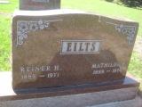
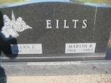
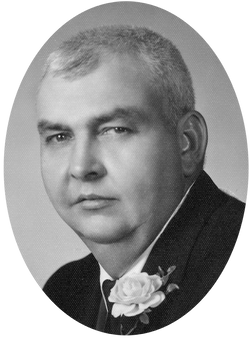
Marlin Reiner Eilts
| Birth | : | 18 Aug 1916 Ireton, Sioux County, Iowa, USA |
| Death | : | Jul 1985 Iowa, USA |
| Burial | : | Chapel Hill Cemetery, Chana, Ogle County, USA |
| Coordinate | : | 41.9310989, -89.2491989 |
frequently asked questions (FAQ):
-
Where is Marlin Reiner Eilts's memorial?
Marlin Reiner Eilts's memorial is located at: Chapel Hill Cemetery, Chana, Ogle County, USA.
-
When did Marlin Reiner Eilts death?
Marlin Reiner Eilts death on Jul 1985 in Iowa, USA
-
Where are the coordinates of the Marlin Reiner Eilts's memorial?
Latitude: 41.9310989
Longitude: -89.2491989
Family Members:
Parent

Spouse
Siblings

Flowers:


Nearby Cemetories:
1. Chapel Hill Cemetery
Chana, Ogle County, USA
Coordinate: 41.9310989, -89.2491989
2. Washington Grove Cemetery
Chana, Ogle County, USA
Coordinate: 41.9315262, -89.2565842
3. Lighthouse Cemetery
Daysville, Ogle County, USA
Coordinate: 41.9466667, -89.3023300
4. Daysville Cemetery
Daysville, Ogle County, USA
Coordinate: 41.9742012, -89.3182983
5. Cooley Cemetery
Chana, Ogle County, USA
Coordinate: 41.9692001, -89.1746979
6. Ashton Cemetery
Ashton, Lee County, USA
Coordinate: 41.8600006, -89.2249985
7. County Farm Cemetery
Oregon, Ogle County, USA
Coordinate: 41.9919014, -89.3328018
8. Flagg Center Cemetery
Flagg Center, Ogle County, USA
Coordinate: 41.9399986, -89.1294022
9. Stinsonian Cemetery
Paynes Point, Ogle County, USA
Coordinate: 42.0236015, -89.2174988
10. Franklin Grove Cemetery
Franklin Grove, Lee County, USA
Coordinate: 41.8440018, -89.3059998
11. Mount Pleasant Cemetery
Paynes Point, Ogle County, USA
Coordinate: 42.0258713, -89.2063065
12. Emmanuel Lutheran Cemetery
Paynes Point, Ogle County, USA
Coordinate: 42.0264091, -89.2071533
13. Riverside Cemetery
Oregon, Ogle County, USA
Coordinate: 42.0177994, -89.3308029
14. Riverview Cemetery
Oregon, Ogle County, USA
Coordinate: 42.0275002, -89.3399963
15. Saint Mary's Cemetery
Oregon, Ogle County, USA
Coordinate: 42.0032997, -89.3767014
16. Girton Cemetery
Lee County, USA
Coordinate: 41.8670006, -89.3899994
17. Saint Brides Episcopal Cemetery
Oregon, Ogle County, USA
Coordinate: 42.0270271, -89.3536911
18. Oak Ridge Cemetery
Grand Detour, Ogle County, USA
Coordinate: 41.9380989, -89.4160995
19. Grand Detour Cemetery
Grand Detour, Ogle County, USA
Coordinate: 41.9020500, -89.4117584
20. Gehant Farm Cemetery
Ashton, Lee County, USA
Coordinate: 41.8089720, -89.2119880
21. Lawnridge Cemetery
Rochelle, Ogle County, USA
Coordinate: 41.9275017, -89.0793991
22. Better Place Forest
Ogle County, USA
Coordinate: 42.0411546, -89.3341425
23. Emmert Cemetery
Nachusa, Lee County, USA
Coordinate: 41.8381004, -89.3660965
24. Saint Peter's Episcopal Church Grounds
Grand Detour, Ogle County, USA
Coordinate: 41.8978300, -89.4147200