
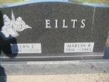
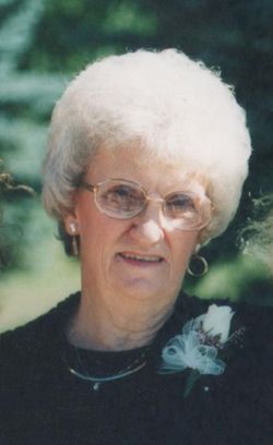
Fern Elizabeth Houlton Eilts
| Birth | : | 6 Apr 1916 Iowa, USA |
| Death | : | 29 Nov 2008 Iowa, USA |
| Burial | : | Kadina Cemetery, Kadina, District Council of Copper Coast, Australia |
| Coordinate | : | -33.9475370, 137.7096720 |
| Description | : | Fern Elizabeth Eilts, 92, of Ireton, Iowa, died in faith on Saturday, November 29, 2008 at the Royale Meadows Care Center in Sioux Center. Fern Elizabeth Eilts was born April 6, 1916 near Ireton, Iowa, the 5th daughter of 8 children to Bruce and Flossie (Thomas) Houlton. She graduated from the Ireton High School in 1933. She married Marlin Reiner Eilts December 25, 1938 on the Houlton farm near Ireton. Fern was employed in the Ireton telephone office from her high school graduation until the married couple moved onto their farm. They farmed near Ireton until moving into Ireton in November... Read More |
frequently asked questions (FAQ):
-
Where is Fern Elizabeth Houlton Eilts's memorial?
Fern Elizabeth Houlton Eilts's memorial is located at: Kadina Cemetery, Kadina, District Council of Copper Coast, Australia.
-
When did Fern Elizabeth Houlton Eilts death?
Fern Elizabeth Houlton Eilts death on 29 Nov 2008 in Iowa, USA
-
Where are the coordinates of the Fern Elizabeth Houlton Eilts's memorial?
Latitude: -33.9475370
Longitude: 137.7096720
Family Members:
Parent

Spouse

Siblings

Flowers:


Nearby Cemetories:
1. Kadina Cemetery
Kadina, District Council of Copper Coast, Australia
Coordinate: -33.9475370, 137.7096720
2. Wallaroo Cemetery
Wallaroo, District Council of Copper Coast, Australia
Coordinate: -33.9403210, 137.6203380
3. Greens Plains West Cemetery
Paskeville, District Council of Copper Coast, Australia
Coordinate: -34.0281650, 137.8644800
4. Moonta Cemetery
Moonta, District Council of Copper Coast, Australia
Coordinate: -34.0750300, 137.5855800
5. Alford Cemetery
Alford, District Council of Barunga West, Australia
Coordinate: -33.8174130, 137.8387910
6. Bute Cemetery
Bute, District Council of Barunga West, Australia
Coordinate: -33.8716030, 137.9918400
7. Saint Pauls Lutheran Church Cemetery
Yorke Peninsula Council, Australia
Coordinate: -34.1773530, 137.8452840
8. Kulpara Cemetery
Kulpara, District Council of Barunga West, Australia
Coordinate: -34.0564360, 138.0223820
9. St. Agatha's Catholic Church Cemetery
Arthurton, Yorke Peninsula Council, Australia
Coordinate: -34.2570190, 137.7576140
10. Arthurton General Cemetery
Arthurton, Yorke Peninsula Council, Australia
Coordinate: -34.2696000, 137.7663000
11. Clinton Centre Uniting Church Cemetery
Clinton Centre, Yorke Peninsula Council, Australia
Coordinate: -34.2344150, 137.9191710
12. Winulta Anglican Cemetery
Winulta, Yorke Peninsula Council, Australia
Coordinate: -34.2779380, 137.8690500
13. Barunga Gap Cemetery
Barunga Gap, Wakefield Regional Council, Australia
Coordinate: -33.8298400, 138.1150070
14. Lochiel Cemetery
Wakefield Regional Council, Australia
Coordinate: -33.9475210, 138.1576680
15. Price Cemetery
Price, Yorke Peninsula Council, Australia
Coordinate: -34.2975830, 137.9779040
16. Salt Lake Cemetery
Bumbunga, Wakefield Regional Council, Australia
Coordinate: -33.8504642, 138.2017451
17. Maitland Cemetery
Maitland, Yorke Peninsula Council, Australia
Coordinate: -34.3674980, 137.6764060
18. Port Wakefield Public Cemetery
Port Wakefield, Wakefield Regional Council, Australia
Coordinate: -34.1665820, 138.1479110
19. St. John's Lutheran Cemetery
South Kilkerran, Yorke Peninsula Council, Australia
Coordinate: -34.4301600, 137.6031500
20. Condowie Cemetery
Condowie, Wakefield Regional Council, Australia
Coordinate: -33.7770500, 138.2748200
21. Keilli Cemetery
Mundoora, District Council of Barunga West, Australia
Coordinate: -33.6002884, 138.1451721
22. Point Pearce Cemetery
Point Pearce, Yorke Peninsula Council, Australia
Coordinate: -34.4208080, 137.5056740
23. Ardrossan Cemetery
Ardrossan, Yorke Peninsula Council, Australia
Coordinate: -34.4244600, 137.9074770
24. Whitwarta Public Cemetery
Whitwarta, Wakefield Regional Council, Australia
Coordinate: -34.0989650, 138.3547620