
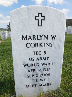
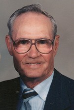
Marlyn Wilbur “Corky” Corkins
| Birth | : | 12 Apr 1927 Rockham, Faulk County, South Dakota, USA |
| Death | : | 2 Sep 2006 Meade County, South Dakota, USA |
| Burial | : | Black Hills National Cemetery, Sturgis, Meade County, USA |
| Coordinate | : | 44.3689003, -103.4753036 |
| Plot | : | J_313 |
| Inscription | : | TEC 5 US ARMY WORLD WAR II |
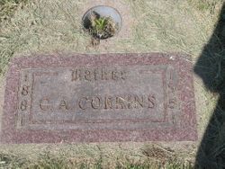
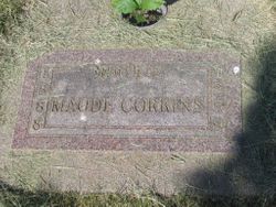
| Description | : | CORKINS, MARLYN WILBUR TEC 5 US ARMY WORLD WAR II Marlyn W. "Corky" Corkins, 79, of Spearfish died Saturday, Sept. 2, 2006, at the Ft. Meade VA Medical Facility in Ft. Meade, S.D. Memorial services will be Wednesday, Sept. 6, 2006, at Saint Joseph's Catholic Church, with Father Tim Hoag officiating, inurnment will be at Black Hills National Cemetery near Sturgis. Marlyn was born in Rockham, S.D., on April 12, 1927, to Carl and Maude (Benning) Corkins. He grew up on a farm near Rockham. He joined the United States Army in... Read More |
frequently asked questions (FAQ):
-
Where is Marlyn Wilbur “Corky” Corkins's memorial?
Marlyn Wilbur “Corky” Corkins's memorial is located at: Black Hills National Cemetery, Sturgis, Meade County, USA.
-
When did Marlyn Wilbur “Corky” Corkins death?
Marlyn Wilbur “Corky” Corkins death on 2 Sep 2006 in Meade County, South Dakota, USA
-
Where are the coordinates of the Marlyn Wilbur “Corky” Corkins's memorial?
Latitude: 44.3689003
Longitude: -103.4753036
Family Members:
Parent
Siblings


Flowers:


Nearby Cemetories:
1. Black Hills National Cemetery
Sturgis, Meade County, USA
Coordinate: 44.3689003, -103.4753036
2. Curley Grimes Memorial Cemetery
Sturgis, Meade County, USA
Coordinate: 44.3764500, -103.4691300
3. Fort Meade National Cemetery
Sturgis, Meade County, USA
Coordinate: 44.4021988, -103.4757996
4. Bear Butte Cemetery
Sturgis, Meade County, USA
Coordinate: 44.4111595, -103.4947968
5. Saint Aloysius Cemetery
Sturgis, Meade County, USA
Coordinate: 44.4141340, -103.5193420
6. Pleasant Valley Cemetery
Tilford, Meade County, USA
Coordinate: 44.3192500, -103.3531160
7. Galena Cemetery
Galena, Lawrence County, USA
Coordinate: 44.3349220, -103.6438410
8. Crook City Cemetery
Crook City, Lawrence County, USA
Coordinate: 44.4432100, -103.6241500
9. Piedmont Cemetery
Piedmont, Meade County, USA
Coordinate: 44.2425780, -103.3871730
10. Oak Ridge Cemetery
Deadwood, Lawrence County, USA
Coordinate: 44.3891983, -103.6766968
11. Whitewood Cemetery
Whitewood, Lawrence County, USA
Coordinate: 44.4617820, -103.6330030
12. Roubaix Cemetery
Roubaix, Lawrence County, USA
Coordinate: 44.2789380, -103.6656600
13. Mount Moriah Cemetery
Deadwood, Lawrence County, USA
Coordinate: 44.3760986, -103.7253036
14. Saint Ambrose Cemetery
Deadwood, Lawrence County, USA
Coordinate: 44.3821983, -103.7266998
15. Nemo Cemetery
Nemo, Lawrence County, USA
Coordinate: 44.1872800, -103.5066410
16. Anderson Cemetery
Lawrence County, USA
Coordinate: 44.4747009, -103.6896973
17. South Lead Cemetery
Lead, Lawrence County, USA
Coordinate: 44.3478510, -103.7606260
18. Little Dane Cemetery
Saint Onge, Lawrence County, USA
Coordinate: 44.5252500, -103.6705540
19. Mountain Meadow Cemetery
Lawrence County, USA
Coordinate: 44.2038994, -103.6557999
20. West Lead Cemetery
Lead, Lawrence County, USA
Coordinate: 44.3484001, -103.7779999
21. Gate of Heaven Cemetery
Saint Onge, Lawrence County, USA
Coordinate: 44.5353000, -103.7237000
22. Terry Cemetery
Terry, Lawrence County, USA
Coordinate: 44.3344290, -103.8165110
23. Vale Cemetery
Vale, Butte County, USA
Coordinate: 44.6138992, -103.4052963
24. Holy Cross Cemetery
Englewood, Lawrence County, USA
Coordinate: 44.2818985, -103.8047028