


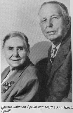
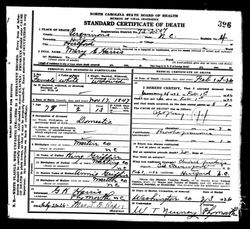
Martha Ann Harris Spruill
| Birth | : | 10 Dec 1873 Martin County, North Carolina, USA |
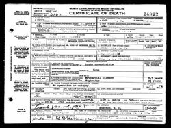
| Death | : | 5 May 1953 Mackeys, Washington County, North Carolina, USA |
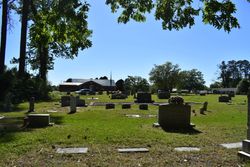
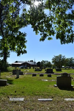
| Burial | : | Saints Delight Church of Christ Cemetery, Plymouth, Washington County, USA |
| Coordinate | : | 35.9094150, -76.6589470 |
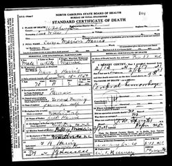
| Description | : | Dau. of George M. & Mary Griffin Harris. COD: Prob. cerebral hemorrhage. |
frequently asked questions (FAQ):
-
Where is Martha Ann Harris Spruill's memorial?
Martha Ann Harris Spruill's memorial is located at: Saints Delight Church of Christ Cemetery, Plymouth, Washington County, USA.
-
When did Martha Ann Harris Spruill death?
Martha Ann Harris Spruill death on 5 May 1953 in Mackeys, Washington County, North Carolina, USA
-
Where are the coordinates of the Martha Ann Harris Spruill's memorial?
Latitude: 35.9094150
Longitude: -76.6589470
Family Members:
Parent
Spouse
Siblings

Children
Flowers:


Nearby Cemetories:
1. Saints Delight Church of Christ Cemetery
Plymouth, Washington County, USA
Coordinate: 35.9094150, -76.6589470
2. Bailey Swain Cemetery
Roper, Washington County, USA
Coordinate: 35.9102400, -76.6541110
3. First Zion Grove Missionary Baptist Church
Roper, Washington County, USA
Coordinate: 35.9046880, -76.6721360
4. Davis Cemetery
Lees Mill Township, Washington County, USA
Coordinate: 35.8975000, -76.6526300
5. Joseph W. Blount Cemetery
Roper, Washington County, USA
Coordinate: 35.9175420, -76.6439460
6. Woodlawn Cemetery
Roper, Washington County, USA
Coordinate: 35.8935400, -76.6552930
7. Davenport Family Plot
Roper, Washington County, USA
Coordinate: 35.8929800, -76.6503300
8. Fountain of Life Baptist Church Cemetery
Roper, Washington County, USA
Coordinate: 35.9190210, -76.6291450
9. Saint Luke Cemetery
Roper, Washington County, USA
Coordinate: 35.8967018, -76.6271973
10. Craft Family Cemetery
Roper, Washington County, USA
Coordinate: 35.9049050, -76.6230320
11. Tarkenton Cemetery
Roper, Washington County, USA
Coordinate: 35.8790700, -76.6540300
12. Griffin H. Cooper Cemetery
Lees Mill Township, Washington County, USA
Coordinate: 35.8791200, -76.6649200
13. Oliver Cemetery
Lees Mill Township, Washington County, USA
Coordinate: 35.8794810, -76.6461390
14. W. J. Mizelle Cemetery
Roper, Washington County, USA
Coordinate: 35.8766810, -76.6493930
15. Macedonia AME Zion Church Cemetery
Roper, Washington County, USA
Coordinate: 35.8757240, -76.6674800
16. Second Zion Grove Church Cemetery
Plymouth, Washington County, USA
Coordinate: 35.8949730, -76.6976000
17. Zions Chapel Church Cemetery
Roper, Washington County, USA
Coordinate: 35.8764870, -76.6420880
18. W. L. Robertson Cemetery
Lees Mill Township, Washington County, USA
Coordinate: 35.8763400, -76.6383500
19. Reid Cemetery
Plymouth, Washington County, USA
Coordinate: 35.8851880, -76.6941520
20. Alfred Blount Cemetery
Roper, Washington County, USA
Coordinate: 35.8989020, -76.6095290
21. John M. Bowen Cemetery
Plymouth Township, Washington County, USA
Coordinate: 35.8750970, -76.6918100
22. Davenport Family Cemetery
Mackeys, Washington County, USA
Coordinate: 35.9305950, -76.6118950
23. Christ Holiness Church Cemetery
Roper, Washington County, USA
Coordinate: 35.8807570, -76.6181670
24. Lincoln Memorial Cemetery
Roper, Washington County, USA
Coordinate: 35.8778760, -76.6209560