
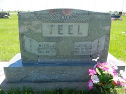
Martha M Harwood Teel
| Birth | : | 1 May 1909 Bay City, Matagorda County, Texas, USA |
| Death | : | 28 Mar 1998 Gothenburg, Dawson County, Nebraska, USA |
| Burial | : | G A R Cemetery, Miller, Hand County, USA |
| Coordinate | : | 44.5078011, -98.9858017 |
| Description | : | Age 88. Of Cozad died at Hilltop Estates in Gothenburg. Daughter of James and Minnie (Dowden) Harwood. As a child, she lived in Texas, Oklahoma and Wyoming. In 1927, she moved to Nebraska and attended the Grand Island Business College. On Feb. 12, 1928, she married Carroll Teel. The couple lived on a farm near Farnam before moving to Elwood in 1942. Mr. Teel died in 1968. She moved to Cozad in 1979. Mrs. Teel was a member of the First United Methodist Church at Elwood and attended Parkview United Methodist Church while living in Cozad. She is survived by... Read More |
frequently asked questions (FAQ):
-
Where is Martha M Harwood Teel's memorial?
Martha M Harwood Teel's memorial is located at: G A R Cemetery, Miller, Hand County, USA.
-
When did Martha M Harwood Teel death?
Martha M Harwood Teel death on 28 Mar 1998 in Gothenburg, Dawson County, Nebraska, USA
-
Where are the coordinates of the Martha M Harwood Teel's memorial?
Latitude: 44.5078011
Longitude: -98.9858017
Family Members:
Spouse

Children
Flowers:


Nearby Cemetories:
1. G A R Cemetery
Miller, Hand County, USA
Coordinate: 44.5078011, -98.9858017
2. Hillcrest Cemetery
Miller, Hand County, USA
Coordinate: 44.5207000, -99.0006100
3. Saint Ann's Cemetery
Miller, Hand County, USA
Coordinate: 44.5222015, -98.9732971
4. Saint Lawrence Cemetery
Saint Lawrence, Hand County, USA
Coordinate: 44.5292015, -98.9321976
5. Morningside Cemetery
Ree Heights, Hand County, USA
Coordinate: 44.5147018, -99.1903000
6. Beulah Cemetery
Vayland, Hand County, USA
Coordinate: 44.6060982, -98.8060989
7. Alden Cemetery
Hand County, USA
Coordinate: 44.6775017, -99.1203003
8. Sunbeam Cemetery
Hand County, USA
Coordinate: 44.6777992, -98.8407974
9. Wessington Cemetery
Hand County, USA
Coordinate: 44.4569016, -98.7102966
10. Saint Josephs Catholic Cemetery
Hand County, USA
Coordinate: 44.4574400, -98.7100400
11. Burdette Cemetery
Burdette, Hand County, USA
Coordinate: 44.7002983, -98.7869034
12. McCord Cemetery
Wessington, Beadle County, USA
Coordinate: 44.3998500, -98.6673100
13. Rosehill Cemetery
Hand County, USA
Coordinate: 44.2980995, -98.7731018
14. Howell Cemetery
Miller, Hand County, USA
Coordinate: 44.7757988, -98.9766998
15. Buffalo Cemetery
Spink County, USA
Coordinate: 44.6918983, -98.6853027
16. Cedar Cemetery
Hand County, USA
Coordinate: 44.2775002, -99.2238998
17. Mount Calvary Cemetery
Polo, Hand County, USA
Coordinate: 44.7827988, -99.1097031
18. Sand Creek Cemetery
Beadle County, USA
Coordinate: 44.3055800, -98.6791200
19. Ebenezer Baptist Cemetery
Hand County, USA
Coordinate: 44.2106018, -98.9056015
20. Mondamin Cemetery
Hand County, USA
Coordinate: 44.2158012, -99.1238022
21. Highmore Cemetery
Highmore, Hyde County, USA
Coordinate: 44.5074997, -99.4197006
22. Saint Marys Catholic Cemetery
Highmore, Hyde County, USA
Coordinate: 44.5063800, -99.4214900
23. Saint Johns Cemetery
Tulare, Spink County, USA
Coordinate: 44.7202988, -98.6600037
24. New Zion Cemetery
Hand County, USA
Coordinate: 44.2043991, -98.8206024