
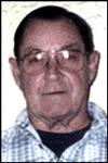
Marvin D. Aldredge
| Birth | : | 9 Mar 1937 Sharpsburg, Taylor County, Iowa, USA |
| Death | : | 3 May 2007 Council Bluffs, Pottawattamie County, Iowa, USA |
| Burial | : | St Mary the Virgin Churchyard, Pulham St Mary, South Norfolk District, England |
| Coordinate | : | 52.4205290, 1.2520380 |
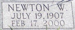
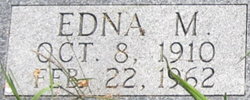
| Description | : | Son of Newton & Edna (Reed) Aldredge. |
frequently asked questions (FAQ):
-
Where is Marvin D. Aldredge's memorial?
Marvin D. Aldredge's memorial is located at: St Mary the Virgin Churchyard, Pulham St Mary, South Norfolk District, England.
-
When did Marvin D. Aldredge death?
Marvin D. Aldredge death on 3 May 2007 in Council Bluffs, Pottawattamie County, Iowa, USA
-
Where are the coordinates of the Marvin D. Aldredge's memorial?
Latitude: 52.4205290
Longitude: 1.2520380
Family Members:
Parent
Siblings

Flowers:


Nearby Cemetories:
1. St Mary the Virgin Churchyard
Pulham St Mary, South Norfolk District, England
Coordinate: 52.4205290, 1.2520380
2. Saint Mary Magdalene Churchyard
Pulham Market, South Norfolk District, England
Coordinate: 52.4285200, 1.2301100
3. Pulham Market Cemetery
Pulham Market, South Norfolk District, England
Coordinate: 52.4281900, 1.2297700
4. St Mary Churchyard
Dickleburgh and Rushall, South Norfolk District, England
Coordinate: 52.3978750, 1.2290680
5. St Peter Churchyard
Needham, South Norfolk District, England
Coordinate: 52.3896320, 1.2773700
6. Saint Margaret's Churchyard
Hardwick, South Norfolk District, England
Coordinate: 52.4632800, 1.2712440
7. Church of the Assumption of the Blessed Virgin Mar
Redenhall, South Norfolk District, England
Coordinate: 52.4104780, 1.3272680
8. All Saints Churchyard
Dickleburgh and Rushall, South Norfolk District, England
Coordinate: 52.3968580, 1.1848010
9. St. Peter and St. Paul Churchyard
Brockdish, South Norfolk District, England
Coordinate: 52.3705240, 1.2366100
10. St. Mary's Churchyard
Shelton, South Norfolk District, England
Coordinate: 52.4720940, 1.2686120
11. All Saints Churchyard
Alburgh, South Norfolk District, England
Coordinate: 52.4362610, 1.3386490
12. St. George's Churchyard
Shimpling, Babergh District, England
Coordinate: 52.3994010, 1.1680910
13. Saint George Churchyard
Shimpling, South Norfolk District, England
Coordinate: 52.3993000, 1.1680000
14. All Saints Churchyard
Mendham, Mid Suffolk District, England
Coordinate: 52.3976310, 1.3349670
15. St. Margaret's Churchyard
Syleham, Mid Suffolk District, England
Coordinate: 52.3641870, 1.2372060
16. Saint Mary Churchyard
Gissing, South Norfolk District, England
Coordinate: 52.4235630, 1.1548260
17. Long Stratton Congregational Churchyard
Long Stratton, South Norfolk District, England
Coordinate: 52.4818890, 1.2324460
18. St Mary's Churchyard
Long Stratton, South Norfolk District, England
Coordinate: 52.4840800, 1.2339000
19. St. Michael's Churchyard
Great Moulton, South Norfolk District, England
Coordinate: 52.4718860, 1.1868760
20. Saint Mary Churchyard
Homersfield, Waveney District, England
Coordinate: 52.4191670, 1.3595410
21. Saint John the Baptist Churchyard
Morningthorpe, South Norfolk District, England
Coordinate: 52.4859170, 1.2654150
22. United Reformed Churchyard
Denton, South Norfolk District, England
Coordinate: 52.4465510, 1.3532090
23. St Leonard Churchyard
Billingford, South Norfolk District, England
Coordinate: 52.3666290, 1.1834260
24. St. Mary's Churchyard
Denton, South Norfolk District, England
Coordinate: 52.4364500, 1.3618770