Mary A. Smith Furry
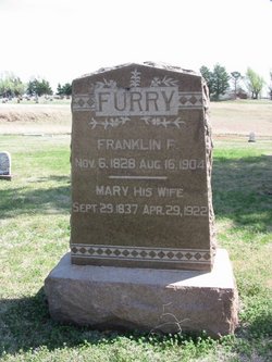
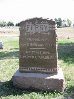
| Birth | : | 29 Sep 1837 Pickaway County, Ohio, USA |
| Death | : | 29 Apr 1922 Kingman, Kingman County, Kansas, USA |
| Burial | : | Great Bend Cemetery, Great Bend, Barton County, USA |
| Coordinate | : | 38.3680992, -98.7996979 |
| Plot | : | 00A-O-13-02 |
| Description | : | Wife of Franklin F. Furry The Hutchinson News Hutchinson, KS Monday, May 8, 1922 Page 16, Column 6 Grandma Furry, the aged widow of Franklin Furry, who lived in Hutchinson in the early days, later locating in Kingman county, is dead at her home in Kingman, aged 84 years, a victim of cancer. The family located in Hutchinson in 1877, later taking a homestead northeast of Kingman. Note: bio info provided by Lorena (#46917011) The Leader-Courier Kingman, KS Friday, May 5, 1922 Page 2, Column 3 OBITUARY—Furry Mrs. Mary Smith Furry was... Read More |
frequently asked questions (FAQ):
-
Where is Mary A. Smith Furry's memorial?
Mary A. Smith Furry's memorial is located at: Great Bend Cemetery, Great Bend, Barton County, USA.
-
When did Mary A. Smith Furry death?
Mary A. Smith Furry death on 29 Apr 1922 in Kingman, Kingman County, Kansas, USA
-
Where are the coordinates of the Mary A. Smith Furry's memorial?
Latitude: 38.3680992
Longitude: -98.7996979
Family Members:
Parent
Spouse
Siblings
Children
Flowers:
Nearby Cemetories:
1. Great Bend Cemetery
Great Bend, Barton County, USA
Coordinate: 38.3680992, -98.7996979
2. Great Bend Cemetery North
Barton County, USA
Coordinate: 38.3761800, -98.8019840
3. Dominican Sisters Resurrection Cemetery
Barton County, USA
Coordinate: 38.3665090, -98.7886990
4. Golden Belt Memorial Park
Great Bend, Barton County, USA
Coordinate: 38.4336014, -98.7850037
5. Hillcrest Memorial Park
Great Bend, Barton County, USA
Coordinate: 38.4361000, -98.7782974
6. Dundee Valley Cemetery
Great Bend, Barton County, USA
Coordinate: 38.3125130, -98.8778980
7. Everett Cemetery
Barton County, USA
Coordinate: 38.3767014, -98.9092026
8. Clarence Township Cemetery
Heizer, Barton County, USA
Coordinate: 38.4052590, -98.9230600
9. Walnut Valley Cemetery
Barton County, USA
Coordinate: 38.4846992, -98.8675003
10. Pleasant Ridge Cemetery
Radium, Stafford County, USA
Coordinate: 38.2475014, -98.8758011
11. Phillips Cemetery
Hoisington, Barton County, USA
Coordinate: 38.5065820, -98.8178650
12. Eden Valley Cemetery
Seward, Stafford County, USA
Coordinate: 38.2182999, -98.7853012
13. Bergthal Mennonite Cemetery
Pawnee Rock, Barton County, USA
Coordinate: 38.3053017, -98.9772034
14. Saint John the Evangelist Catholic Cemetery
Hoisington, Barton County, USA
Coordinate: 38.5214005, -98.7938995
15. Hoisington Cemetery
Hoisington, Barton County, USA
Coordinate: 38.5209300, -98.7693400
16. Saint Pauls Lutheran Cemetery
Albert, Barton County, USA
Coordinate: 38.3770000, -99.0005900
17. Patterson Cemetery
Barton County, USA
Coordinate: 38.4019012, -98.9963989
18. Saint Francis Xavier Cemetery
Seward, Stafford County, USA
Coordinate: 38.2038994, -98.8193970
19. Wilson Cemetery
Hoisington, Barton County, USA
Coordinate: 38.5361520, -98.7541870
20. Pawnee Rock State Historic Site
Pawnee Rock, Barton County, USA
Coordinate: 38.2721800, -98.9815300
21. Pawnee Rock Cemetery
Pawnee Rock, Barton County, USA
Coordinate: 38.2771988, -98.9858017
22. Lakin Comanche Cemetery
Ellinwood, Barton County, USA
Coordinate: 38.3486000, -98.5736000
23. Olivet Cemetery
Hoisington, Barton County, USA
Coordinate: 38.5438995, -98.8499985
24. Peace Lutheran Cemetery
Timken, Rush County, USA
Coordinate: 38.3837600, -99.0330750

