
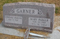
Mary Adalate Parker Garner
| Birth | : | 11 Nov 1919 Dawson, Dallas County, Iowa, USA |
| Death | : | 14 Aug 2004 Adams, Gage County, Nebraska, USA |
| Burial | : | St. Mary the Virgin Churchyard, Prescot, Metropolitan Borough of Knowsley, England |
| Coordinate | : | 53.4284600, -2.8067000 |
| Description | : | Mary Adalate Garner, 84, Humboldt, died Saturday (8/14/04). Born, Dawson, Iowa. School teacher. Survivors: husband, Edward; brother, Edra Parker, Iowa; sister, Laura Slycord, DeSoto, Iowa. Services: 10:30 a.m. Wednesday, Wherry Mortuary, Humboldt. Pleasant Hill Cemetery (Prairie Center Church Cemetery), rural Dallas County, Iowa. Visitation: 2-8 p.m. today, mortuary. Memorials to Pella Reformed Church, 15901 Pella Road, Adams, NE 68301. |
frequently asked questions (FAQ):
-
Where is Mary Adalate Parker Garner's memorial?
Mary Adalate Parker Garner's memorial is located at: St. Mary the Virgin Churchyard, Prescot, Metropolitan Borough of Knowsley, England.
-
When did Mary Adalate Parker Garner death?
Mary Adalate Parker Garner death on 14 Aug 2004 in Adams, Gage County, Nebraska, USA
-
Where are the coordinates of the Mary Adalate Parker Garner's memorial?
Latitude: 53.4284600
Longitude: -2.8067000
Family Members:
Parent

Spouse

Siblings
Flowers:


Nearby Cemetories:
1. St. Mary the Virgin Churchyard
Prescot, Metropolitan Borough of Knowsley, England
Coordinate: 53.4284600, -2.8067000
2. Prescot Cemetery
Prescot, Metropolitan Borough of Knowsley, England
Coordinate: 53.4266620, -2.8081590
3. St. Nicholas' Churchyard
Whiston, Metropolitan Borough of Knowsley, England
Coordinate: 53.4069736, -2.8028920
4. Knowsley Cemetery
Knowsley, Metropolitan Borough of Knowsley, England
Coordinate: 53.4083240, -2.7847870
5. St. Michael Churchyard
Huyton with Roby, Metropolitan Borough of Knowsley, England
Coordinate: 53.4139560, -2.8396720
6. St. Agnes Roman Catholic
Huyton with Roby, Metropolitan Borough of Knowsley, England
Coordinate: 53.4090600, -2.8320100
7. St Michael Churchyard Extension
Huyton with Roby, Metropolitan Borough of Knowsley, England
Coordinate: 53.4143310, -2.8418050
8. St Ann’s Graveyard
Rainhill, Metropolitan Borough of St Helens, England
Coordinate: 53.4157487, -2.7638276
9. Christ Church Churchyard
Eccleston, Metropolitan Borough of St Helens, England
Coordinate: 53.4542560, -2.7778900
10. St. Bartholomew's Churchyard
Huyton with Roby, Metropolitan Borough of Knowsley, England
Coordinate: 53.4120023, -2.8556125
11. St Bartholomew's Churchyard
Rainhill, Metropolitan Borough of St Helens, England
Coordinate: 53.4076231, -2.7513287
12. St. Mary's Churchyard
Knowsley, Metropolitan Borough of Knowsley, England
Coordinate: 53.4561960, -2.8528580
13. GreenAcres Cemetery
Rainford, Metropolitan Borough of St Helens, England
Coordinate: 53.4713530, -2.8064280
14. Yew Tree Roman Catholic Cemetery
West Derby, Metropolitan Borough of Liverpool, England
Coordinate: 53.4285700, -2.8790700
15. St. Helen's Cemetery and Crematorium
St Helens, Metropolitan Borough of St Helens, England
Coordinate: 53.4678993, -2.7607000
16. Windleshaw Chantry
St Helens, Metropolitan Borough of St Helens, England
Coordinate: 53.4672417, -2.7550773
17. Friends Meeting House, Hardshaw, St Helens
St Helens, Metropolitan Borough of St Helens, England
Coordinate: 53.4518340, -2.7320414
18. St Nicholas Churchyard
St Helens, Metropolitan Borough of St Helens, England
Coordinate: 53.4284660, -2.7213830
19. St. John the Evangelist Churchyard
Knotty Ash, Metropolitan Borough of Liverpool, England
Coordinate: 53.4160757, -2.8913708
20. All Saints Churchyard
Childwall, Metropolitan Borough of Liverpool, England
Coordinate: 53.3952880, -2.8816030
21. Broadgreen Jewish Cemetery
Liverpool, Metropolitan Borough of Liverpool, England
Coordinate: 53.4101320, -2.8977320
22. St. Anne and Blessed Dominic Churchyard
St Helens, Metropolitan Borough of St Helens, England
Coordinate: 53.4330960, -2.7083700
23. St. Nicholas Churchyard
Halewood, Metropolitan Borough of Knowsley, England
Coordinate: 53.3694400, -2.8284900
24. St Swithins Churchyard
Liverpool, Metropolitan Borough of Liverpool, England
Coordinate: 53.4585631, -2.9012280