
| Birth | : | 20 Jun 1814 Rockingham County, Virginia, USA |
| Death | : | 11 Feb 1886 Van Buren County, Iowa, USA |
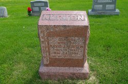
| Burial | : | Mount Moriah Cemetery, Douds, Van Buren County, USA |
| Coordinate | : | 40.8710000, -92.0860000 |
| Description | : | Wife of M. |
frequently asked questions (FAQ):
-
Where is Mary Ann “Polly” Detamore Armentrout's memorial?
Mary Ann “Polly” Detamore Armentrout's memorial is located at: Mount Moriah Cemetery, Douds, Van Buren County, USA.
-
When did Mary Ann “Polly” Detamore Armentrout death?
Mary Ann “Polly” Detamore Armentrout death on 11 Feb 1886 in Van Buren County, Iowa, USA
-
Where are the coordinates of the Mary Ann “Polly” Detamore Armentrout's memorial?
Latitude: 40.8710000
Longitude: -92.0860000
Family Members:
Parent
Spouse

Siblings
Children
Flowers:


Nearby Cemetories:
1. Mount Moriah Cemetery
Douds, Van Buren County, USA
Coordinate: 40.8710000, -92.0860000
2. Zion Lutheran Cemetery
Douds, Van Buren County, USA
Coordinate: 40.8563000, -92.0664000
3. Boyer Family Cemetery
Leando, Van Buren County, USA
Coordinate: 40.8333560, -92.1112885
4. Leando Cemetery
Douds, Van Buren County, USA
Coordinate: 40.8269005, -92.0883026
5. Winsell Cemetery
Fairfield, Jefferson County, USA
Coordinate: 40.9067001, -92.1247025
6. Passmore Cemetery
Van Buren County, USA
Coordinate: 40.8608017, -92.1549988
7. White Chapel Cemetery
Birmingham, Van Buren County, USA
Coordinate: 40.8417015, -92.0203018
8. Iowaville Cemetery
Selma, Van Buren County, USA
Coordinate: 40.8861008, -92.1628036
9. Bethel Cemetery
Birmingham, Van Buren County, USA
Coordinate: 40.8967018, -92.0056000
10. Fell Cemetery
Libertyville, Jefferson County, USA
Coordinate: 40.9375000, -92.0772018
11. Hem Cemetery
Davis County, USA
Coordinate: 40.8389015, -92.1785965
12. Rominger Cemetery
Batavia, Jefferson County, USA
Coordinate: 40.9379000, -92.1503000
13. Roush Cemetery
Chequest Township, Van Buren County, USA
Coordinate: 40.7872009, -92.0755997
14. Chief Black Hawk Burial Site
Floris, Davis County, USA
Coordinate: 40.8852780, -92.1972220
15. Hissem Cemetery
Selma, Van Buren County, USA
Coordinate: 40.8030784, -92.1587902
16. Cumberland Cemetery
Jefferson County, USA
Coordinate: 40.9248000, -91.9903000
17. Mathias Cemetery
Van Buren County, USA
Coordinate: 40.8031000, -92.1681000
18. Thompson Cemetery
Jefferson County, USA
Coordinate: 40.9155998, -91.9772034
19. Jefferson County Poor Farm Cemetery
Libertyville, Jefferson County, USA
Coordinate: 40.9416900, -91.9996200
20. Heidlebaugh Cemetery
Davis County, USA
Coordinate: 40.8165800, -92.1933500
21. Valentine Cemetery
Keosauqua, Van Buren County, USA
Coordinate: 40.7743988, -92.0460968
22. Clinkinbeard Family Cemetery
Libertyville, Jefferson County, USA
Coordinate: 40.9083300, -91.9583300
23. Chequest Miller Cemetery
Van Buren County, USA
Coordinate: 40.7847200, -92.1641300
24. Spencer Farm Cemetery
Leando, Van Buren County, USA
Coordinate: 40.7847200, -92.1641300