
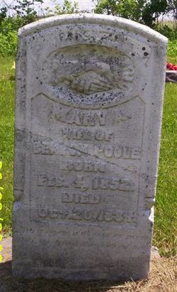
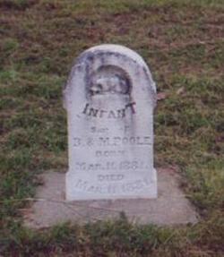
Mary Ann Stinson Poole
| Birth | : | 4 Feb 1852 Iowa, USA |
| Death | : | 20 Oct 1884 Farmington, Van Buren County, Iowa, USA |
| Burial | : | Melton Mowbray Church of England, Melton Mowbray, Southern Midlands Council, Australia |
| Coordinate | : | -42.4721458, 147.1806319 |
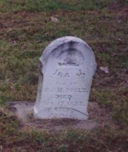
| Description | : | Mary Stinson was the 2nd wide of Benton Poole. They were married 28 Apr 1881. She bore two children, an infant son died at birth and a son Ira who lived 26 days. |
frequently asked questions (FAQ):
-
Where is Mary Ann Stinson Poole's memorial?
Mary Ann Stinson Poole's memorial is located at: Melton Mowbray Church of England, Melton Mowbray, Southern Midlands Council, Australia.
-
When did Mary Ann Stinson Poole death?
Mary Ann Stinson Poole death on 20 Oct 1884 in Farmington, Van Buren County, Iowa, USA
-
Where are the coordinates of the Mary Ann Stinson Poole's memorial?
Latitude: -42.4721458
Longitude: 147.1806319
Family Members:
Parent
Spouse
Siblings

Children
Flowers:


Nearby Cemetories:
1. Melton Mowbray Church of England
Melton Mowbray, Southern Midlands Council, Australia
Coordinate: -42.4721458, 147.1806319
2. St Mary’s Anglican Church Cemetery
Kempton, Southern Midlands Council, Australia
Coordinate: -42.5282960, 147.2012760
3. St. Peter’s Catholic Church Cemetery
Kempton, Southern Midlands Council, Australia
Coordinate: -42.5299560, 147.1968150
4. Kempton Congregational Cemetery
Kempton, Southern Midlands Council, Australia
Coordinate: -42.5361860, 147.2038090
5. St. Bartholomew's Anglican Church Cemetery
Apsley, Central Highlands Council, Australia
Coordinate: -42.4047140, 147.1409820
6. St. Anne's Anglican Church Cemetery
Dysart, Southern Midlands Council, Australia
Coordinate: -42.5753650, 147.2165400
7. St. James' Church of England Cemetery
Jericho, Southern Midlands Council, Australia
Coordinate: -42.3791420, 147.2902790
8. St John the Evangelist Anglican Cemetery
Lower Marshes, Southern Midlands Council, Australia
Coordinate: -42.3464730, 147.2088010
9. Bagdad Uniting Church Cemetery
Bagdad, Southern Midlands Council, Australia
Coordinate: -42.6084120, 147.2222760
10. St Patrick’s Catholic Church Cemetery
Colebrook, Southern Midlands Council, Australia
Coordinate: -42.5349600, 147.3620500
11. St. James Anglican Cemetery
Colebrook, Southern Midlands Council, Australia
Coordinate: -42.5371373, 147.3641418
12. Bothwell Public Cemetery
Bothwell, Central Highlands Council, Australia
Coordinate: -42.3823080, 147.0098440
13. Bothwell Methodist Cemetery
Bothwell, Central Highlands Council, Australia
Coordinate: -42.3815380, 147.0077990
14. St. Michael's Anglican Cemetery
Bagdad, Southern Midlands Council, Australia
Coordinate: -42.6263790, 147.2226500
15. Dennistoun Private Cemetery
Bothwell, Central Highlands Council, Australia
Coordinate: -42.3330001, 147.0670013
16. Broadmarsh Congregational Cemetery
Broadmarsh, Southern Midlands Council, Australia
Coordinate: -42.6344620, 147.1129760
17. St. Augustine's Anglican Cemetery
Broadmarsh, Southern Midlands Council, Australia
Coordinate: -42.6380880, 147.1158740
18. Oatlands Uniting Church Cemetery
Oatlands, Southern Midlands Council, Australia
Coordinate: -42.3109880, 147.3679270
19. Tunnack Cemetery
Tunnack, Southern Midlands Council, Australia
Coordinate: -42.4720970, 147.4701690
20. Oatlands General Cemetery
Oatlands, Southern Midlands Council, Australia
Coordinate: -42.3091980, 147.3748150
21. St. Mark's Anglican Cemetery
Pontville, Southern Midlands Council, Australia
Coordinate: -42.6807150, 147.2663860
22. Oatlands Wesleyan Cemetery
Oatlands, Southern Midlands Council, Australia
Coordinate: -42.3030090, 147.3697930
23. St. James Anglican Church Cemetery
Hollow Tree, Central Highlands Council, Australia
Coordinate: -42.4708990, 146.8817810
24. St. Peter's Church of England Cemetery
Oatlands, Southern Midlands Council, Australia
Coordinate: -42.2971080, 147.3692140