

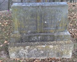
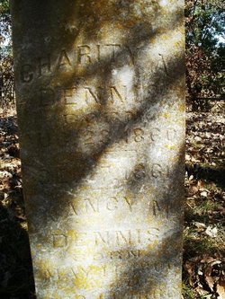
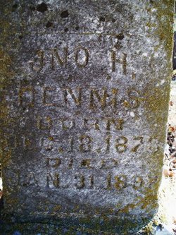
Mary Ann Young Dennis
| Birth | : | 3 Oct 1826 Adair County, Kentucky, USA |
| Death | : | 18 Apr 1908 Mitchell Township, Nemaha County, Kansas, USA |
| Burial | : | Bluemont Cemetery, Grafton, Taylor County, USA |
| Coordinate | : | 39.3446999, -80.0121994 |
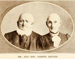
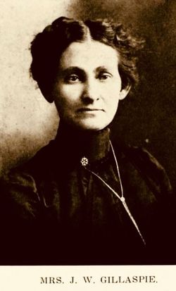
| Description | : | Time gathered to his harvest another of the early settlers of Nemaha County last Saturday, in the person of Mrs. J. W. Dennis. "Uncle Joe" Dennis and wife are known and beloved of everyone in this section. Theirs has been an ideal companionship, in which each has been mutually helpful to the other, sharing to the full extent the trials and toils as well as the joys and compensation of a long married life. No one knew them but to admire their simple honesty, charity and neighborly good will. In the long years of pioneer days of northeastern Kansas, theirs... Read More |
frequently asked questions (FAQ):
-
Where is Mary Ann Young Dennis's memorial?
Mary Ann Young Dennis's memorial is located at: Bluemont Cemetery, Grafton, Taylor County, USA.
-
When did Mary Ann Young Dennis death?
Mary Ann Young Dennis death on 18 Apr 1908 in Mitchell Township, Nemaha County, Kansas, USA
-
Where are the coordinates of the Mary Ann Young Dennis's memorial?
Latitude: 39.3446999
Longitude: -80.0121994
Family Members:
Spouse
Children


Flowers:


Nearby Cemetories:
1. Bluemont Cemetery
Grafton, Taylor County, USA
Coordinate: 39.3446999, -80.0121994
2. Mount Calvary Catholic Cemetery
Grafton, Taylor County, USA
Coordinate: 39.3492012, -80.0171967
3. Old Catholic Cemetery
Taylor County, USA
Coordinate: 39.3445200, -80.0243000
4. Knotts Cemetery
Grafton, Taylor County, USA
Coordinate: 39.3550030, -80.0170860
5. Reese Cemetery
Grafton, Taylor County, USA
Coordinate: 39.3604990, -80.0068620
6. Grafton National Cemetery
Grafton, Taylor County, USA
Coordinate: 39.3350296, -80.0312500
7. Lantz Ford Cemetery
Grafton, Taylor County, USA
Coordinate: 39.3219370, -80.0132820
8. Carder Cemetery
Fetterman, Taylor County, USA
Coordinate: 39.3618760, -80.0409150
9. Keener Cemetery
Grafton, Taylor County, USA
Coordinate: 39.3502370, -80.0503460
10. Warder Cemetery
Pruntytown, Taylor County, USA
Coordinate: 39.3360670, -80.0549330
11. Current Cemetery
Taylor County, USA
Coordinate: 39.3642006, -79.9753036
12. Woodsdale Memorial Park
Pruntytown, Taylor County, USA
Coordinate: 39.3408012, -80.0658035
13. Brown Cemetery
Taylor County, USA
Coordinate: 39.3841630, -80.0295590
14. Wesley Chapel Cemetery
Grafton, Taylor County, USA
Coordinate: 39.3044014, -79.9922028
15. Arnold Cemetery
Grafton, Taylor County, USA
Coordinate: 39.2985115, -80.0014712
16. West Virginia National Cemetery
Pruntytown, Taylor County, USA
Coordinate: 39.3350190, -80.0730590
17. Knottsville Cemetery
Knottsville, Taylor County, USA
Coordinate: 39.3125000, -79.9642029
18. Payne Cemetery
Thornton, Taylor County, USA
Coordinate: 39.3482220, -79.9440680
19. Wiseman Cemetery
Pruntytown, Taylor County, USA
Coordinate: 39.3602170, -80.0782840
20. Beulah Cemetery
Pruntytown, Taylor County, USA
Coordinate: 39.3336590, -80.0817140
21. Abram Smith Cemetery
Pruntytown, Taylor County, USA
Coordinate: 39.3314018, -80.0811005
22. Haymond Cemetery
Grafton, Taylor County, USA
Coordinate: 39.3807240, -79.9579350
23. Linn and Hickman Cemetery
Marion County, USA
Coordinate: 39.4007988, -80.0286026
24. Amnon Cemetery
Taylor County, USA
Coordinate: 39.4007988, -79.9878006