
Mary Armilda Kay Clark Termuhlen
| Birth | : | 16 Jan 1886 Missouri, USA |
| Death | : | 17 Aug 1975 Denison, Crawford County, Iowa, USA |
| Burial | : | Valley of the Sun Mortuary and Cemetery, Chandler, Maricopa County, USA |
| Coordinate | : | 33.2330818, -111.8478851 |
| Plot | : | Block 26, Row 5 |
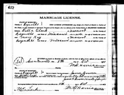
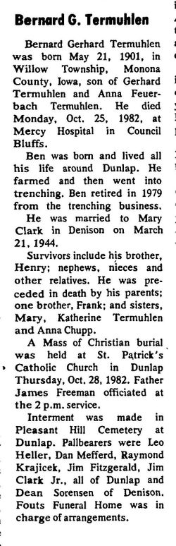
| Description | : | 1st Spouse Missouri, Marriage Records, 1805-2002 Name: Mary Kay Marriage Date: 9 Oct 1910 Marriage Place: Reynolds, Missouri, USA Spouse: Rolla Vernon Clark 1885–1950 Children: Inez Clark Schliep 1908–1971 Hazel Violet Clark Rees 1911–2002 https://www.findagrave.com/memorial/6349231/hazel-v.-rees William Arthur Clark 1913–1970 https://www.findagrave.com/memorial/5226807/william-arthur-clark Elsie Maxine Clark Williams 1916–1988 |
frequently asked questions (FAQ):
-
Where is Mary Armilda Kay Clark Termuhlen's memorial?
Mary Armilda Kay Clark Termuhlen's memorial is located at: Valley of the Sun Mortuary and Cemetery, Chandler, Maricopa County, USA.
-
When did Mary Armilda Kay Clark Termuhlen death?
Mary Armilda Kay Clark Termuhlen death on 17 Aug 1975 in Denison, Crawford County, Iowa, USA
-
Where are the coordinates of the Mary Armilda Kay Clark Termuhlen's memorial?
Latitude: 33.2330818
Longitude: -111.8478851
Family Members:
Parent
Spouse
Siblings
Children

Flowers:


Nearby Cemetories:
1. Valley of the Sun Mortuary and Cemetery
Chandler, Maricopa County, USA
Coordinate: 33.2330818, -111.8478851
2. Goodyear-Ocotillo Cemetery
Chandler, Maricopa County, USA
Coordinate: 33.2360992, -111.8486023
3. Risen Savior Lutheran Church Columbarium
Chandler, Maricopa County, USA
Coordinate: 33.2296040, -111.8596590
4. Sun Lakes Methodist Church Columbarium
Sun Lakes, Maricopa County, USA
Coordinate: 33.2183800, -111.8829900
5. Snaketown Cemetery
Santan, Pinal County, USA
Coordinate: 33.1822530, -111.9086410
6. Holy Trinity Lutheran Church Memory Gardens
Chandler, Maricopa County, USA
Coordinate: 33.3094100, -111.8532100
7. Saint Matthew’s Episcopal Church Memorial Garden
Chandler, Maricopa County, USA
Coordinate: 33.3092540, -111.8573010
8. Stotonic Cemetery
Stotonic, Pinal County, USA
Coordinate: 33.1567590, -111.7981930
9. Gilbert Memorial Park
Gilbert, Maricopa County, USA
Coordinate: 33.2633783, -111.7456097
10. Lower Santan Cemetery
Sacaton, Pinal County, USA
Coordinate: 33.1493430, -111.7892470
11. Bapchule Cemetery
Bapchule, Pinal County, USA
Coordinate: 33.1367500, -111.8791200
12. Sweetwater Cemetery
Sweetwater, Pinal County, USA
Coordinate: 33.1319975, -111.8406922
13. Sand Trail Cemetery
Sweetwater, Pinal County, USA
Coordinate: 33.1284880, -111.8523050
14. Santan Day School Cemetery
Sacaton, Pinal County, USA
Coordinate: 33.1412500, -111.7647590
15. Mission del Sol Presbyterian Church Columbarium
Tempe, Maricopa County, USA
Coordinate: 33.3347090, -111.9145440
16. First United Methodist Church Columbarium
Gilbert, Maricopa County, USA
Coordinate: 33.3435440, -111.8057160
17. Desert Cross Lutheran Church Columbarium
Tempe, Maricopa County, USA
Coordinate: 33.3372060, -111.9117590
18. Saint James Episcopal Church Memorial Garden
Tempe, Maricopa County, USA
Coordinate: 33.3343160, -111.9274950
19. Vah-Ki Cemetery
Casa Blanca, Pinal County, USA
Coordinate: 33.1175700, -111.9053300
20. Saint Ann Cemetery
Pinal County, USA
Coordinate: 33.1241989, -111.7397003
21. Cowboy Cemetery
Sacate, Pinal County, USA
Coordinate: 33.1408400, -111.9776700
22. Upper Santan Cemetery
Sacaton, Pinal County, USA
Coordinate: 33.1232420, -111.7376830
23. Desert Palm United Church of Christ Columbarium
Tempe, Maricopa County, USA
Coordinate: 33.3647120, -111.9184340
24. Gethsemane Lutheran Church Memorial Garden
Tempe, Maricopa County, USA
Coordinate: 33.3634360, -111.9246770