
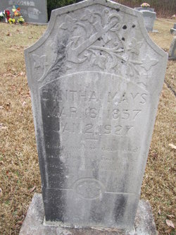
Mary Cynthia Creed Mays
| Birth | : | 11 Mar 1857 Wilkes County, North Carolina, USA |
| Death | : | 25 Dec 1926 Dobson, Surry County, North Carolina, USA |
| Burial | : | St. Mary's Churchyard, Tickhill, Metropolitan Borough of Doncaster, England |
| Coordinate | : | 53.4309200, -1.1112200 |
| Description | : | Wife of John Mays; daughter of Jeff Creed and wife. Note: It appears the death date on her grave stone may be in error. Her death certificate, though poorly annotated, indicates death occurred on Christmas Day, 1926 with burial the next day by Joe Brown of Ladonia, NC. Floyd Mays served as the informant but there is no attending physician's name or cause of death annotated. Oddly, the document wasn't filed by the County Registrar until June 3, 1927. |
frequently asked questions (FAQ):
-
Where is Mary Cynthia Creed Mays's memorial?
Mary Cynthia Creed Mays's memorial is located at: St. Mary's Churchyard, Tickhill, Metropolitan Borough of Doncaster, England.
-
When did Mary Cynthia Creed Mays death?
Mary Cynthia Creed Mays death on 25 Dec 1926 in Dobson, Surry County, North Carolina, USA
-
Where are the coordinates of the Mary Cynthia Creed Mays's memorial?
Latitude: 53.4309200
Longitude: -1.1112200
Family Members:
Spouse
Children

Flowers:


Nearby Cemetories:
1. St. Mary's Churchyard
Tickhill, Metropolitan Borough of Doncaster, England
Coordinate: 53.4309200, -1.1112200
2. Saint Mary's Cemetery
Tickhill, Metropolitan Borough of Doncaster, England
Coordinate: 53.4315867, -1.1108661
3. Austin Friars Churchyard
Tickhill, Metropolitan Borough of Doncaster, England
Coordinate: 53.4283270, -1.1194740
4. Tickhill Friary
Tickhill, Metropolitan Borough of Doncaster, England
Coordinate: 53.4283330, -1.1195830
5. Styrrup Road Cemetery
Harworth, Bassetlaw District, England
Coordinate: 53.4160400, -1.0816770
6. All Saints Churchyard
Harworth, Bassetlaw District, England
Coordinate: 53.4187800, -1.0781900
7. Harworth Cemetery
Harworth, Bassetlaw District, England
Coordinate: 53.4185060, -1.0733460
8. Sandbeck Park
Maltby, Metropolitan Borough of Rotherham, England
Coordinate: 53.4061450, -1.1460050
9. St Winifred Churchyard
Stainton, Metropolitan Borough of Doncaster, England
Coordinate: 53.4367385, -1.1657988
10. St Helen's Roman Catholic Churchyard
Nottingham, Nottingham Unitary Authority, England
Coordinate: 53.3903220, -1.1131860
11. St. John the Baptist Churchyard
Wadworth, Metropolitan Borough of Doncaster, England
Coordinate: 53.4673170, -1.1447000
12. Rossington Cemetery
Rossington, Metropolitan Borough of Doncaster, England
Coordinate: 53.4704340, -1.0896950
13. Rossington Grange Lane Cemetery
New Rossington, Metropolitan Borough of Doncaster, England
Coordinate: 53.4705000, -1.0897200
14. St. Martin Churchyard
Firbeck, Metropolitan Borough of Rotherham, England
Coordinate: 53.3900080, -1.1561770
15. Maltby Cemetery
Maltby, Metropolitan Borough of Rotherham, England
Coordinate: 53.4255480, -1.1960280
16. Roche Abbey
Maltby, Metropolitan Borough of Rotherham, England
Coordinate: 53.4025000, -1.1834000
17. Respect Green Burial Park
Bawtry, Metropolitan Borough of Doncaster, England
Coordinate: 53.4200210, -1.0250520
18. St. Katherine Churchyard
Loversall, Metropolitan Borough of Doncaster, England
Coordinate: 53.4821700, -1.1333650
19. Langold Cemetery
Worksop, Bassetlaw District, England
Coordinate: 53.3777600, -1.1170100
20. St Nicholas Chapel of All Souls Ancillary Cemetery
Bawtry, Metropolitan Borough of Doncaster, England
Coordinate: 53.4344798, -1.0211632
21. Bawtry Cemetery
Bawtry, Metropolitan Borough of Doncaster, England
Coordinate: 53.4341255, -1.0192066
22. St. Nicholas' Churchyard
Bawtry, Metropolitan Borough of Doncaster, England
Coordinate: 53.4297900, -1.0183400
23. St. Michael's Churchyard
Rossington, Metropolitan Borough of Doncaster, England
Coordinate: 53.4782772, -1.0596305
24. St. James' Churchyard
Braithwell, Metropolitan Borough of Doncaster, England
Coordinate: 53.4465700, -1.2035400