
| Birth | : | 28 Dec 1931 Clay Center, Clay County, Kansas, USA |
| Death | : | 27 Nov 2020 Clay Center, Clay County, Kansas, USA |
| Burial | : | Greenwood Cemetery, Clay Center, Clay County, USA |
| Coordinate | : | 39.4011002, -97.1275024 |
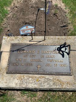
| Description | : | Mary E. Kopfer, 88, of Clay Center, died, Friday, November 27, 2020 at Medicalodge. She was born on December 28, 1931 at Clay Center, the daughter of Edward and Adeline (Fitzgerald) Hatfield. Mary grew up in Clay Center and graduated from CCCHS in 1949. She married Leon Kopfer on April 22, 1950 and he preceded her in death on August 8, 1999. They farmed in the Broughton area. Mary worked for Key Feeds egg production and managed the Clay County Park. She was a member of the Clay Center ELKS and the American Legion Auxiliary. She is also preceded in... Read More |
frequently asked questions (FAQ):
-
Where is Mary E. Hatfield Kopfer's memorial?
Mary E. Hatfield Kopfer's memorial is located at: Greenwood Cemetery, Clay Center, Clay County, USA.
-
When did Mary E. Hatfield Kopfer death?
Mary E. Hatfield Kopfer death on 27 Nov 2020 in Clay Center, Clay County, Kansas, USA
-
Where are the coordinates of the Mary E. Hatfield Kopfer's memorial?
Latitude: 39.4011002
Longitude: -97.1275024
Family Members:
Parent

Spouse
Siblings
Flowers:


Nearby Cemetories:
1. Greenwood Cemetery
Clay Center, Clay County, USA
Coordinate: 39.4011002, -97.1275024
2. Saint Peter and Saint Pauls Catholic Cemetery
Clay Center, Clay County, USA
Coordinate: 39.4005450, -97.1236680
3. Clay County Poor Farm Cemetery
Clay Center, Clay County, USA
Coordinate: 39.3772700, -97.0727000
4. Wilson Cemetery
Clay County, USA
Coordinate: 39.3800011, -97.1896973
5. Hayes Cemetery
Clay County, USA
Coordinate: 39.4516983, -97.0811005
6. Republican City Cemetery
Clay Center, Clay County, USA
Coordinate: 39.3431015, -97.1628036
7. Swedish Pleasant Hill Cemetery
Clay Center, Clay County, USA
Coordinate: 39.4735985, -97.1268997
8. Morganville City Cemetery
Morganville, Clay County, USA
Coordinate: 39.4733009, -97.1819000
9. Broughton Cemetery
Clay Center, Clay County, USA
Coordinate: 39.3306007, -97.0535965
10. Swedish Evangelical Lutheran Cemetery
Clay County, USA
Coordinate: 39.4911700, -97.1455100
11. Ebenezer Cemetery
Green, Clay County, USA
Coordinate: 39.3866997, -96.9974976
12. Brethren in Christ Cemetery
Clay County, USA
Coordinate: 39.4810982, -97.0344009
13. Green Cemetery
Green, Clay County, USA
Coordinate: 39.4235992, -96.9882965
14. Norwegian Lutheran Cemetery
Clay Center, Clay County, USA
Coordinate: 39.5027900, -97.1828200
15. Zion Lutheran Cemetery
Clay County, USA
Coordinate: 39.2928009, -97.1557999
16. Idylwilde Cemetery
Clay Center, Clay County, USA
Coordinate: 39.5097900, -97.0713000
17. Idana Cemetery
Idana, Clay County, USA
Coordinate: 39.3574500, -97.2693300
18. Milo Chapman Gravesite
Broughton, Clay County, USA
Coordinate: 39.2888500, -97.0724400
19. Fancy Creek Cemetery
Green, Clay County, USA
Coordinate: 39.4668999, -96.9969025
20. Garfield Center Mission Cemetery
Clay Center, Clay County, USA
Coordinate: 39.5243100, -97.1277500
21. Gilbert Cemetery
Clay County, USA
Coordinate: 39.2853012, -97.0625000
22. Bloom Cemetery
Morganville, Clay County, USA
Coordinate: 39.4519005, -97.2778015
23. Joseph Sender Family Cemetery
Clay County, USA
Coordinate: 39.5090600, -97.0348800
24. Lincoln Cemetery
Clay Center, Clay County, USA
Coordinate: 39.4230995, -97.2930984