
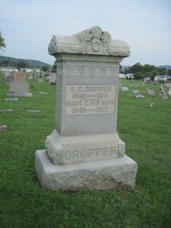
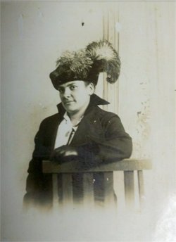
Mary E Robison Cropper
| Birth | : | 15 Dec 1849 Aberdeen, Brown County, Ohio, USA |
| Death | : | 21 Jul 1937 Highland County, Ohio, USA |
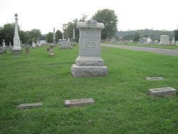
| Burial | : | Pleasant Cross Christian Church Cemetery, Asheboro, Randolph County, USA |
| Coordinate | : | 35.7254000, -79.7268740 |
frequently asked questions (FAQ):
-
Where is Mary E Robison Cropper's memorial?
Mary E Robison Cropper's memorial is located at: Pleasant Cross Christian Church Cemetery, Asheboro, Randolph County, USA.
-
When did Mary E Robison Cropper death?
Mary E Robison Cropper death on 21 Jul 1937 in Highland County, Ohio, USA
-
Where are the coordinates of the Mary E Robison Cropper's memorial?
Latitude: 35.7254000
Longitude: -79.7268740
Family Members:
Parent
Spouse

Siblings

Children
Flowers:


Nearby Cemetories:
1. Providence Baptist Church Cemetery
Asheboro, Randolph County, USA
Coordinate: 35.7231400, -79.7237930
2. Shady Grove Community Cemetery
Asheboro, Randolph County, USA
Coordinate: 35.7192180, -79.7287920
3. Billy Trogdon Cemetery
Asheboro, Randolph County, USA
Coordinate: 35.7392800, -79.7219100
4. Cedar Falls United Methodist Church Cemetery
Asheboro, Randolph County, USA
Coordinate: 35.7472920, -79.7338990
5. Cedar Falls Baptist Church Cemetery
Cedar Falls, Randolph County, USA
Coordinate: 35.7480800, -79.7357800
6. Clear View Baptist Church Cemetery
Franklinville, Randolph County, USA
Coordinate: 35.7530800, -79.7234300
7. Franklinville United Methodist Church Cemetery
Franklinville, Randolph County, USA
Coordinate: 35.7462900, -79.7037500
8. Mount Tabor Community Church Cemetery
Asheboro, Randolph County, USA
Coordinate: 35.6892900, -79.7318400
9. First Baptist Church Cemetery
Franklinville, Randolph County, USA
Coordinate: 35.7482230, -79.6908630
10. Giles Chapel United Methodist Church Cemetery
Asheboro, Randolph County, USA
Coordinate: 35.7462270, -79.7752450
11. Old Salem Cemetery
Franklinville, Randolph County, USA
Coordinate: 35.7414017, -79.6742020
12. Spoons Chapel United Church of Christ Cemetery
Asheboro, Randolph County, USA
Coordinate: 35.6763150, -79.7345110
13. Mountain of Faith Christian Church Cemetery
Asheboro, Randolph County, USA
Coordinate: 35.6760930, -79.7129830
14. Pleasant Ridge Christian Church Cemetery
Ramseur, Randolph County, USA
Coordinate: 35.7046860, -79.6670060
15. God Outreach Ministries Cemetery
Asheboro, Randolph County, USA
Coordinate: 35.7473240, -79.7890130
16. Ramseur Wesleyan Church Cemetery
Ramseur, Randolph County, USA
Coordinate: 35.7305670, -79.6593030
17. Mount Calvary Cemetery
Asheboro, Randolph County, USA
Coordinate: 35.7095920, -79.7940450
18. Oddfellow-McAlister Cemetery
Asheboro, Randolph County, USA
Coordinate: 35.7090670, -79.7942090
19. Bethel Friends Cemetery
Asheboro, Randolph County, USA
Coordinate: 35.6645700, -79.7391200
20. Sunset Knoll Cemetery
Ramseur, Randolph County, USA
Coordinate: 35.7313995, -79.6500015
21. Liberty Road Baptist Church Cemetery
Randleman, Randolph County, USA
Coordinate: 35.7715500, -79.7808130
22. Baileys Grove Baptist Church Cemetery
Asheboro, Randolph County, USA
Coordinate: 35.7404060, -79.8075610
23. Neighbors Grove Wesleyan Church Cemetery
Asheboro, Randolph County, USA
Coordinate: 35.7509200, -79.8045030
24. Harmony Baptist Church Cemetery
Ramseur, Randolph County, USA
Coordinate: 35.7241680, -79.6418910