

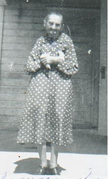
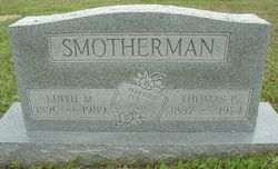
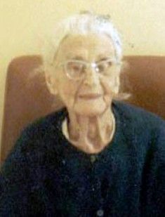
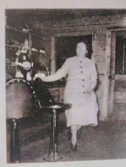
Mary 'Edith' Harrod Smotherman
| Birth | : | 14 Aug 1896 Woodside, Oregon County, Missouri, USA |
| Death | : | 13 Mar 1989 Birch Tree, Shannon County, Missouri, USA |
| Burial | : | Cementerio Municipal Viejo, Yauco, Yauco Municipality, USA |
| Coordinate | : | 18.0356000, -66.8561600 |
| Inscription | : | Married 20 Feb 1920 |
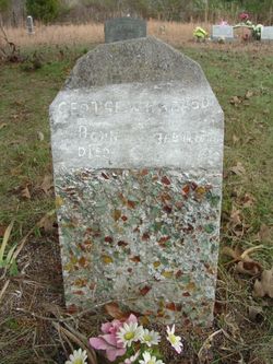
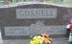
| Description | : | Mary Edith Smotherman was born August 14, 1896 at Oregon County, Missouri the daughter of George Washington and Martha Greer Harrod and passed away Monday, March 13, 1989 at the Birch Tree Nursing Center in Birch Tree, Missouri. She was united in marriage to Thomas P. Smotherman on February 20, 1920 and to this union six children were born. She was preceded in death by her parents, husband, Thomas, one son, Coy, one infant daughter, three brothers, and two sisters. She is survived by one son, Dale Smotherman of Proctorville, Ohio; four daughters, Juanita Gosnell of Birch Tree, MO; Olive... Read More |
frequently asked questions (FAQ):
-
Where is Mary 'Edith' Harrod Smotherman's memorial?
Mary 'Edith' Harrod Smotherman's memorial is located at: Cementerio Municipal Viejo, Yauco, Yauco Municipality, USA.
-
When did Mary 'Edith' Harrod Smotherman death?
Mary 'Edith' Harrod Smotherman death on 13 Mar 1989 in Birch Tree, Shannon County, Missouri, USA
-
Where are the coordinates of the Mary 'Edith' Harrod Smotherman's memorial?
Latitude: 18.0356000
Longitude: -66.8561600
Family Members:
Parent
Spouse
Siblings
Children


Nearby Cemetories:
1. Cementerio Municipal Viejo
Yauco, Yauco Municipality, USA
Coordinate: 18.0356000, -66.8561600
2. Cementerio Municipal Nuevo
Yauco, Yauco Municipality, USA
Coordinate: 18.0353500, -66.8568700
3. Santa Basilica Metropolitana Iglesia Catedral
Santiago de Cuba, Municipio de Santiago de Cuba, Cuba
Coordinate: 18.0384400, -66.8712700
4. Cementerio Nuevo Los Pinos
Guayanilla, Guayanilla Municipality, USA
Coordinate: 18.0172020, -66.7952230
5. Cementerio Municipal de Guayanilla
Guayanilla, Guayanilla Municipality, USA
Coordinate: 18.0247726, -66.7870865
6. Cementerio Municipal de Guanica
Guanica, Guanica Municipality, USA
Coordinate: 17.9800910, -66.9204540
7. Getsemaní Memorial Park
Susua, Sabana Grande Municipality, USA
Coordinate: 18.0825900, -66.9439900
8. Cementerio Masónico Sabana Grande
Sabana Grande, Sabana Grande Municipality, USA
Coordinate: 18.0801400, -66.9678500
9. Cementerio Municipal
Sabana Grande, Sabana Grande Municipality, USA
Coordinate: 18.0802212, -66.9678879
10. Cementerio Penuelas
Penuelas, Penuelas Municipality, USA
Coordinate: 18.0557080, -66.7260120
11. Cementerio Municipal Yahuecas
Adjuntas, Adjuntas Municipality, USA
Coordinate: 18.1885900, -66.7773100
12. Cementerio Río Prieto
Castaner, Lares Municipality, USA
Coordinate: 18.2085125, -66.8974098
13. Cementerio Luz del Gigante
Adjuntas, Adjuntas Municipality, USA
Coordinate: 18.1658260, -66.7290920
14. Cementerio Porta Coeli
San German, San German Municipality, USA
Coordinate: 18.0904730, -67.0385420
15. Camposanto de Cristo Resucitado
Ponce, Ponce Municipality, USA
Coordinate: 17.9791720, -66.6655760
16. Cementerio Municipal
Maricao, Maricao Municipality, USA
Coordinate: 18.1855520, -66.9833010
17. Antiguo Cementerio Municipal
San German, San German Municipality, USA
Coordinate: 18.0825750, -67.0527120
18. Cementerio Trujillo
San German, San German Municipality, USA
Coordinate: 18.0816680, -67.0532020
19. Cementerio Municipal De Lajas
Lajas, Lajas Municipality, USA
Coordinate: 18.0448700, -67.0610500
20. Cementerio La Piedad
Ponce, Ponce Municipality, USA
Coordinate: 18.0409320, -66.6462850
21. Cementerio Católico San Vicente de Paul
Ponce, Ponce Municipality, USA
Coordinate: 18.0170790, -66.6337570
22. Cementerio Civil de Ponce
Ponce, Ponce Municipality, USA
Coordinate: 18.0146870, -66.6326730
23. Cementerio El Yeso
Ponce, Ponce Municipality, USA
Coordinate: 18.0351250, -66.6243110
24. Cementerio Municipal de la Playa
Ponce, Ponce Municipality, USA
Coordinate: 17.9848850, -66.6288700