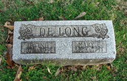
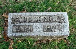
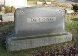
Mary Elizabeth Iserman DeLong
| Birth | : | 27 May 1868 Hocking County, Ohio, USA |
| Death | : | 14 Dec 1945 Lancaster, Fairfield County, Ohio, USA |
| Burial | : | Clinton-Garfield Cemetery, Rolfe, Pocahontas County, USA |
| Coordinate | : | 42.8055300, -94.5202500 |
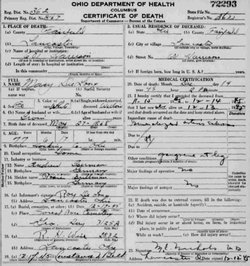
| Description | : | Following from Bradley DeLong grt-grandson of subject: (11/12/2000) Mary E. Iserman: Born May 27, 1868 in Fairfield County (her d.c. has her born Hocking Co., OH). Died December 14, 1945 in Lancaster, Ohio. Buried in Forest Rose Cemetery. Daughter of Andrew Iserman and Lucinda Brillman. (Mary's death certificate lists mother as Rosie Bullman. I believe the mother was probably called Rosie and there was probably an error in spelling the last name). Note: anyone trying to track Mary Iserman or her parents through the census records should be aware of the... Read More |
frequently asked questions (FAQ):
-
Where is Mary Elizabeth Iserman DeLong's memorial?
Mary Elizabeth Iserman DeLong's memorial is located at: Clinton-Garfield Cemetery, Rolfe, Pocahontas County, USA.
-
When did Mary Elizabeth Iserman DeLong death?
Mary Elizabeth Iserman DeLong death on 14 Dec 1945 in Lancaster, Fairfield County, Ohio, USA
-
Where are the coordinates of the Mary Elizabeth Iserman DeLong's memorial?
Latitude: 42.8055300
Longitude: -94.5202500
Family Members:
Parent
Spouse
Children
Flowers:
Nearby Cemetories:
1. Clinton-Garfield Cemetery
Rolfe, Pocahontas County, USA
Coordinate: 42.8055300, -94.5202500
2. Saint Margarets Cemetery
Rolfe, Pocahontas County, USA
Coordinate: 42.8164978, -94.5307465
3. Old Rolfe Cemetery
Rolfe, Pocahontas County, USA
Coordinate: 42.8403511, -94.4764175
4. Powhatan Cemetery
Plover, Pocahontas County, USA
Coordinate: 42.8557396, -94.5801773
5. Saint Johns Catholic Cemetery
Gilmore City, Pocahontas County, USA
Coordinate: 42.7332993, -94.4672012
6. Marble Valley Cemetery
Gilmore City, Humboldt County, USA
Coordinate: 42.7458850, -94.4430150
7. McKnight Cemetery
Bode, Humboldt County, USA
Coordinate: 42.8635100, -94.4055600
8. Omer-Thorsen Farm Cemetery
Ottosen, Humboldt County, USA
Coordinate: 42.8735742, -94.4085743
9. Calvary Cemetery
Pocahontas, Pocahontas County, USA
Coordinate: 42.7335000, -94.6597000
10. Summit Hill Cemetery
Pocahontas, Pocahontas County, USA
Coordinate: 42.7315000, -94.6595000
11. Union Cemetery
Ottosen, Humboldt County, USA
Coordinate: 42.8879128, -94.3792496
12. Mount Hope Cemetery
Unique, Humboldt County, USA
Coordinate: 42.7169250, -94.3740570
13. Washington Cemetery
Havelock, Pocahontas County, USA
Coordinate: 42.8363250, -94.7091440
14. Riverside Cemetery
West Bend, Palo Alto County, USA
Coordinate: 42.9512000, -94.5120000
15. Ellington Cemetery
Ellington Township, Palo Alto County, USA
Coordinate: 42.9377000, -94.6240400
16. Lincoln Cemetery
West Bend, Palo Alto County, USA
Coordinate: 42.9596842, -94.5602466
17. West Bend Cemetery
West Bend, Palo Alto County, USA
Coordinate: 42.9590000, -94.4548000
18. Apostolic V Christian Cemetery
Kossuth County, USA
Coordinate: 42.9630870, -94.4238290
19. Saint Johns Lutheran Cemetery
Palmer, Pocahontas County, USA
Coordinate: 42.6268997, -94.5205994
20. Saint Olaf Churchyard Cemetery
Bode, Humboldt County, USA
Coordinate: 42.8653600, -94.2858300
21. Saint Josephs Cemetery
Palmer, Pocahontas County, USA
Coordinate: 42.6342010, -94.6188965
22. Saint Olaf Lutheran Cemetery
Bode, Humboldt County, USA
Coordinate: 42.8628000, -94.2773000
23. Rutland Township Cemetery
Rutland, Humboldt County, USA
Coordinate: 42.7574997, -94.2652969
24. Saint Paul Lutheran Cemetery
Palmer, Pocahontas County, USA
Coordinate: 42.6176000, -94.5893500

