
| Birth | : | 24 Mar 1852 Fairfield, Jefferson County, Iowa, USA |
| Death | : | 24 Dec 1888 Libertyville, Jefferson County, Iowa, USA |
| Burial | : | Fell Cemetery, Libertyville, Jefferson County, USA |
| Coordinate | : | 40.9375000, -92.0772018 |
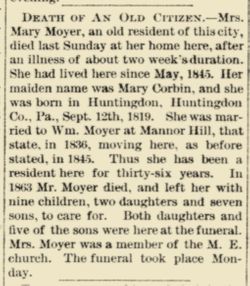
| Description | : | Wife of Hiel Dunsmore Miller, mother of Mabel Helen, Arthur Hiel, Ethel Harriet, William Clyde, Beulah, and Roy Fred (a/k/a Fred Dean) Miller. "Lizzie" Moyer was hired by Hiel to teach at Des Moines Township School No. 5 and boarded with him. They later married. |
frequently asked questions (FAQ):
-
Where is Mary Elizabeth “Lizzie” Moyer Miller's memorial?
Mary Elizabeth “Lizzie” Moyer Miller's memorial is located at: Fell Cemetery, Libertyville, Jefferson County, USA.
-
When did Mary Elizabeth “Lizzie” Moyer Miller death?
Mary Elizabeth “Lizzie” Moyer Miller death on 24 Dec 1888 in Libertyville, Jefferson County, Iowa, USA
-
Where are the coordinates of the Mary Elizabeth “Lizzie” Moyer Miller's memorial?
Latitude: 40.9375000
Longitude: -92.0772018
Family Members:
Parent
Spouse

Siblings
Children
Flowers:


Nearby Cemetories:
1. Fell Cemetery
Libertyville, Jefferson County, USA
Coordinate: 40.9375000, -92.0772018
2. Winsell Cemetery
Fairfield, Jefferson County, USA
Coordinate: 40.9067001, -92.1247025
3. Morgan Burial Plot
Des Moines Township, Jefferson County, USA
Coordinate: 40.9837160, -92.0964340
4. McCleary Cemetery
Jefferson County, USA
Coordinate: 40.9892006, -92.0805969
5. Brethren Cemetery
Batavia, Jefferson County, USA
Coordinate: 40.9768000, -92.1240000
6. Rominger Cemetery
Batavia, Jefferson County, USA
Coordinate: 40.9379000, -92.1503000
7. Jefferson County Poor Farm Cemetery
Libertyville, Jefferson County, USA
Coordinate: 40.9416900, -91.9996200
8. Mount Moriah Cemetery
Douds, Van Buren County, USA
Coordinate: 40.8710000, -92.0860000
9. Cumberland Cemetery
Jefferson County, USA
Coordinate: 40.9248000, -91.9903000
10. Smith Family Cemetery
Libertyville, Jefferson County, USA
Coordinate: 40.9972416, -92.0362857
11. Bethel Cemetery
Birmingham, Van Buren County, USA
Coordinate: 40.8967018, -92.0056000
12. Gregg Cemetery
Jefferson County, USA
Coordinate: 41.0078011, -92.0811005
13. Thompson Cemetery
Jefferson County, USA
Coordinate: 40.9155998, -91.9772034
14. Zion Lutheran Cemetery
Douds, Van Buren County, USA
Coordinate: 40.8563000, -92.0664000
15. Iowaville Cemetery
Selma, Van Buren County, USA
Coordinate: 40.8861008, -92.1628036
16. Batavia Cemetery
Batavia, Jefferson County, USA
Coordinate: 40.9977080, -92.1661100
17. Koons Cemetery
Locust Grove Township, Jefferson County, USA
Coordinate: 41.0286410, -92.0948960
18. Roth Cemetery
Fairfield, Jefferson County, USA
Coordinate: 40.9589005, -91.9574966
19. Clinkinbeard Family Cemetery
Libertyville, Jefferson County, USA
Coordinate: 40.9083300, -91.9583300
20. Coon Cemetery
Jefferson County, USA
Coordinate: 41.0266991, -92.1243973
21. Des Moines River Cemetery
Wapello County, USA
Coordinate: 40.9463000, -92.2042000
22. Passmore Cemetery
Van Buren County, USA
Coordinate: 40.8608017, -92.1549988
23. Courtney Cemetery
Jefferson County, USA
Coordinate: 40.9997711, -92.1788559
24. Memorial Lawn Cemetery
Fairfield, Jefferson County, USA
Coordinate: 41.0068000, -91.9805000