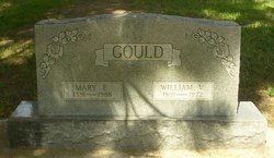
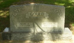
Mary Elizabeth Miller Gould
| Birth | : | 19 Jun 1891 West Plains, Howell County, Missouri, USA |
| Death | : | 22 Oct 1988 Newcastle, Weston County, Wyoming, USA |
| Burial | : | Custer Cemetery, Custer, Custer County, USA |
| Coordinate | : | 43.7781181, -103.6159592 |
| Plot | : | Block 2, Lot 8, Grave 4 |
| Description | : | Services for Mary E. Gould, 97, will be 2 p.m. Tuesday in the McColley Funeral Home Chapel in Newcastle, with the Rev. David Barkey of First Baptist Church officiating. Burial will follow in Custer (SD) Cemetery. Mrs. Gould died Saturday, October 22, 1988, at Weston Manor Nursing Home in Newcastle. A memorial has been established to the nursing home. She was born June 19, 1891, at West Plains, MO, to James and Elizabeth (Eubank) Miller, and was educated in Howell County, MO. She married William V. Gould July 2, 1910. The couple lived at West Plains and operataed a sawmill. In 1911 they moved... Read More |
frequently asked questions (FAQ):
-
Where is Mary Elizabeth Miller Gould's memorial?
Mary Elizabeth Miller Gould's memorial is located at: Custer Cemetery, Custer, Custer County, USA.
-
When did Mary Elizabeth Miller Gould death?
Mary Elizabeth Miller Gould death on 22 Oct 1988 in Newcastle, Weston County, Wyoming, USA
-
Where are the coordinates of the Mary Elizabeth Miller Gould's memorial?
Latitude: 43.7781181
Longitude: -103.6159592
Family Members:
Spouse
Children
Flowers:
Nearby Cemetories:
1. Custer Cemetery
Custer, Custer County, USA
Coordinate: 43.7781181, -103.6159592
2. Thunderhead Mountain
Custer, Custer County, USA
Coordinate: 43.8346510, -103.6221890
3. McGillycuddy Monument
Pennington County, USA
Coordinate: 43.8865110, -103.5670850
4. Major James Whitehead Burial Site
Custer County, USA
Coordinate: 43.7169500, -103.4535500
5. Hill City Cemetery
Hill City, Pennington County, USA
Coordinate: 43.9366270, -103.5789730
6. Pringle Cemetery
Pringle, Custer County, USA
Coordinate: 43.6086006, -103.6042023
7. Cold Springs Cemetery
Custer County, USA
Coordinate: 43.6232700, -103.5075000
8. Keystone Cemetery
Keystone, Pennington County, USA
Coordinate: 43.8835983, -103.4147034
9. Harney City Cemetery
Harney, Pennington County, USA
Coordinate: 43.8908000, -103.3887800
10. Hayward Cemetery
Pennington County, USA
Coordinate: 43.8879500, -103.3511800
11. Wind Cave National Park Cemetery
Pringle, Custer County, USA
Coordinate: 43.5579400, -103.4793600
12. Rockerville Cemetery
Rockerville, Pennington County, USA
Coordinate: 43.9681015, -103.3572006
13. Cornelius Donahue Burial Site
Custer County, USA
Coordinate: 43.6079380, -103.2996950
14. Highland Park Cemetery
Hermosa, Custer County, USA
Coordinate: 43.8386750, -103.2044510
15. Fairburn Cemetery
Fairburn, Custer County, USA
Coordinate: 43.6871986, -103.1956024
16. Reynolds Ranch Cemetery
Rochford, Pennington County, USA
Coordinate: 44.0875667, -103.8027265
17. Minnekahta Valley Cemetery
Minnekahta, Fall River County, USA
Coordinate: 43.4402800, -103.6133300
18. Evergreen Cemetery
Hot Springs, Fall River County, USA
Coordinate: 43.4458008, -103.4843979
19. Bell Park Cemetery
Rochford, Pennington County, USA
Coordinate: 44.1116982, -103.7466965
20. State Veterans Home Cemetery
Hot Springs, Fall River County, USA
Coordinate: 43.4362020, -103.5007810
21. Hot Springs National Cemetery
Hot Springs, Fall River County, USA
Coordinate: 43.4394684, -103.4722214
22. Boot Hill Cemetery
Buffalo Gap, Custer County, USA
Coordinate: 43.4874600, -103.3205660
23. Pine Lawn Memorial Park
Rapid City, Pennington County, USA
Coordinate: 44.0410995, -103.2472000
24. Buffalo Gap Cemetery
Fall River County, USA
Coordinate: 43.4747009, -103.3131027


