
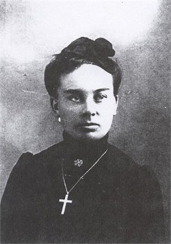
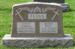

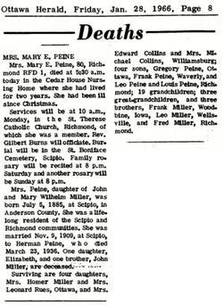
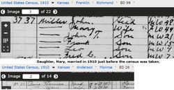
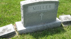
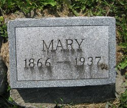
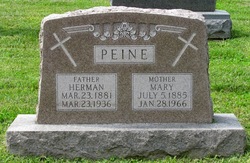
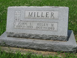
Mary Elizabeth Miller Peine
| Birth | : | 5 Jul 1885 Richmond, Franklin County, Kansas, USA |
| Death | : | 28 Jan 1966 Ottawa, Franklin County, Kansas, USA |
| Burial | : | Mountain View Cemetery, Farmington, Whitman County, USA |
| Coordinate | : | 47.0774500, -117.0409900 |
frequently asked questions (FAQ):
-
Where is Mary Elizabeth Miller Peine's memorial?
Mary Elizabeth Miller Peine's memorial is located at: Mountain View Cemetery, Farmington, Whitman County, USA.
-
When did Mary Elizabeth Miller Peine death?
Mary Elizabeth Miller Peine death on 28 Jan 1966 in Ottawa, Franklin County, Kansas, USA
-
Where are the coordinates of the Mary Elizabeth Miller Peine's memorial?
Latitude: 47.0774500
Longitude: -117.0409900
Family Members:
Parent
Spouse
Siblings

Children


Flowers:


Nearby Cemetories:
1. Mountain View Cemetery
Farmington, Whitman County, USA
Coordinate: 47.0774500, -117.0409900
2. Silver Creek Cemetery
Farmington, Whitman County, USA
Coordinate: 47.0344009, -117.0535965
3. Garfield Cemetery
Garfield, Whitman County, USA
Coordinate: 46.9999100, -117.1498600
4. Sacred Heart Mission Cemetery
De Smet, Benewah County, USA
Coordinate: 47.1461110, -116.9136110
5. Freeze Cemetery
Freeze, Latah County, USA
Coordinate: 46.9633000, -116.9492000
6. Goldenrod Cemetery
Tekoa, Whitman County, USA
Coordinate: 47.2117004, -117.0727997
7. Oakesdale Cemetery
Oakesdale, Whitman County, USA
Coordinate: 47.1371994, -117.2407990
8. Elberton Cemetery
Elberton, Whitman County, USA
Coordinate: 46.9821100, -117.2108300
9. Eden Valley Cemetery
Palouse, Whitman County, USA
Coordinate: 46.9407997, -117.1472015
10. Sacred Heart Catholic Cemetery
Tekoa, Whitman County, USA
Coordinate: 47.2398300, -117.0587100
11. Lone Pine Cemetery
Tekoa, Whitman County, USA
Coordinate: 47.2256012, -117.1489029
12. Mountain View Cemetery
Tensed, Benewah County, USA
Coordinate: 47.1064700, -116.7944700
13. Greenwood Cemetery
Palouse, Whitman County, USA
Coordinate: 46.9043999, -117.0686035
14. Mendenhall Cemetery
Latah County, USA
Coordinate: 46.9314000, -116.8752000
15. Potlatch Cemetery
Potlatch, Latah County, USA
Coordinate: 46.9226189, -116.8893814
16. Sanders Cemetery
Sanders, Benewah County, USA
Coordinate: 47.1014000, -116.7640000
17. Rock Creek Cemetery
Potlatch, Latah County, USA
Coordinate: 46.8914864, -116.8950260
18. Latah Cemetery
Latah, Spokane County, USA
Coordinate: 47.2821999, -117.1264038
19. Bethel Cemetery
Steptoe, Whitman County, USA
Coordinate: 47.0052986, -117.3460999
20. Latah Evergreen Cemetery
Latah, Spokane County, USA
Coordinate: 47.2961006, -117.1619034
21. Thornton Cemetery
Thornton, Whitman County, USA
Coordinate: 47.1146355, -117.3807907
22. Coleman Cemetery
Fallon, Whitman County, USA
Coordinate: 46.8444310, -117.0963620
23. Sheahan Cemetery
Thornton, Whitman County, USA
Coordinate: 47.1091000, -117.3868000
24. Viola Cemetery
Viola, Latah County, USA
Coordinate: 46.8380000, -117.0340000