
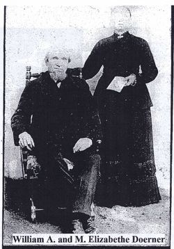
Mary Elizabeth Schmitte Doerner
| Birth | : | 14 Oct 1820 Kaltenholzhausen, Rhein-Lahn-Kreis, Rheinland-Pfalz, Germany |
| Death | : | 27 Feb 1901 Hunts Corners, Huron County, Ohio, USA |
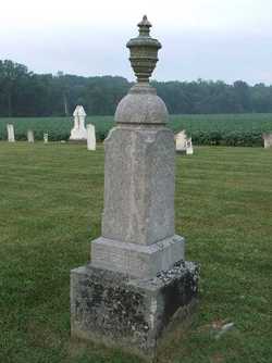
| Burial | : | Crescent Memorial Park, Pennsauken, Camden County, USA |
| Coordinate | : | 39.9710999, -75.0449982 |
| Plot | : | Section 4, Row 4 |
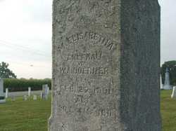
| Inscription | : | M. Elizabeth ehefrau von W.A. Doerner gest. 27 Feb 1901 alt 80j 4m 16t |
| Description | : | Mary Elizabeth Doerner Mrs. Mary Elizabeth Doerner, died at 5 4 o'clock, Wednesday morning at the home of her son, Charles, on Broad street, aged 80 years, 4 months and 13 days. She was born in Kalten Holzhausen, Amt. Deitz, Provenz, Nassau, Germany October 14th, 1820. She was united in marriage with Mr. W.A. Doerner in Germany, and two children were born to them in that country -W.A. of this city, and Fred of Morehead. The other son, Charles, was born in this country. They came to America in 1857, locating in Hunt's Corners (now Moorehead).... Read More |
frequently asked questions (FAQ):
-
Where is Mary Elizabeth Schmitte Doerner's memorial?
Mary Elizabeth Schmitte Doerner's memorial is located at: Crescent Memorial Park, Pennsauken, Camden County, USA.
-
When did Mary Elizabeth Schmitte Doerner death?
Mary Elizabeth Schmitte Doerner death on 27 Feb 1901 in Hunts Corners, Huron County, Ohio, USA
-
Where are the coordinates of the Mary Elizabeth Schmitte Doerner's memorial?
Latitude: 39.9710999
Longitude: -75.0449982
Family Members:
Spouse
Children

Flowers:


Nearby Cemetories:
1. Crescent Memorial Park
Pennsauken, Camden County, USA
Coordinate: 39.9710999, -75.0449982
2. Saint Matthews Methodist Cemetery
Pennsauken Township, Camden County, USA
Coordinate: 39.9725680, -75.0472610
3. Sunset Memorial Park
Pennsauken, Camden County, USA
Coordinate: 39.9761009, -75.0447006
4. Bethel Memorial Park
Pennsauken, Camden County, USA
Coordinate: 39.9653015, -75.0569000
5. Arlington Cemetery
Pennsauken, Camden County, USA
Coordinate: 39.9682070, -75.0594950
6. Jordantown Lawns Cemetery
Jordantown, Camden County, USA
Coordinate: 39.9627400, -75.0251300
7. Christs Bible Church Cemetery
Pennsauken, Camden County, USA
Coordinate: 39.9628300, -75.0250500
8. Grace Episcopal Church Columbarium
Merchantville, Camden County, USA
Coordinate: 39.9507910, -75.0482840
9. Johnson Cemetery
Camden, Camden County, USA
Coordinate: 39.9479700, -75.0705300
10. Palmyra Moravian Church Cemetery
Cinnaminson, Burlington County, USA
Coordinate: 39.9881200, -75.0108670
11. Morgan Cemetery
Palmyra, Burlington County, USA
Coordinate: 39.9949989, -75.0167007
12. Bridesburg Presbyterian Church Cemetery
Bridesburg, Philadelphia County, USA
Coordinate: 40.0023370, -75.0655790
13. All Saints Roman Catholic Church Cemetery
Philadelphia, Philadelphia County, USA
Coordinate: 40.0012210, -75.0700740
14. Most Holy Redeemer Cemetery
Philadelphia, Philadelphia County, USA
Coordinate: 39.9977989, -75.0768967
15. Epworth Methodist Church Cemetery
Palmyra, Burlington County, USA
Coordinate: 40.0030136, -75.0217972
16. Emanuel United Church of Christ Cemetery
Bridesburg, Philadelphia County, USA
Coordinate: 40.0025220, -75.0707410
17. Trinity AME Church Cemetery
Cinnaminson, Burlington County, USA
Coordinate: 39.9848600, -74.9989290
18. Bethany Lutheran Church Memorial Garden
Palmyra, Burlington County, USA
Coordinate: 40.0041700, -75.0196400
19. Epworth United Methodist Church Memorial Garden
Palmyra, Burlington County, USA
Coordinate: 40.0061860, -75.0208700
20. Calvary Cemetery
Cherry Hill, Camden County, USA
Coordinate: 39.9314003, -75.0582962
21. Saint Patricks Cemetery (Defunct)
Camden, Camden County, USA
Coordinate: 39.9463840, -75.0885670
22. Calvary Presbyterian Church Memorial Garden
Riverton, Burlington County, USA
Coordinate: 40.0104480, -75.0168810
23. Westfield Friends Burial Ground
Cinnaminson, Burlington County, USA
Coordinate: 39.9952100, -74.9925100
24. Christ Episcopal Memorial Garden
Riverton, Burlington County, USA
Coordinate: 40.0118446, -75.0146637