
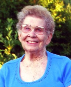
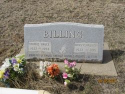
Mary Ella Shawver Billing
| Birth | : | 8 Jul 1923 Garfield County, Montana, USA |
| Death | : | 14 Aug 2015 Jordan, Garfield County, Montana, USA |
| Burial | : | Pioneer Cemetery, Jordan, Garfield County, USA |
| Coordinate | : | 47.3244019, -106.9238968 |
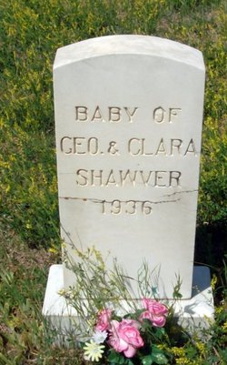
| Description | : | Mary Billing, 92, of Jordan passed away peacefully in the Garfield County Health Center early Friday morning, August 14, 2015. The angels added another flower to The Master's Bouquet. Mary was born July 8th, 1923 to George & Clara (Bacon) Shawver in a log home on their Squaw Creek homestead in present-day western Garfield County. She had fond memories of growing up with her 7 siblings, riding horses, attending country school, haying, playing pranks and even the hard winters. Mary loved to reminisce about her early days. In 1936, the family moved to California where she graduated from high school... Read More |
frequently asked questions (FAQ):
-
Where is Mary Ella Shawver Billing's memorial?
Mary Ella Shawver Billing's memorial is located at: Pioneer Cemetery, Jordan, Garfield County, USA.
-
When did Mary Ella Shawver Billing death?
Mary Ella Shawver Billing death on 14 Aug 2015 in Jordan, Garfield County, Montana, USA
-
Where are the coordinates of the Mary Ella Shawver Billing's memorial?
Latitude: 47.3244019
Longitude: -106.9238968
Family Members:
Parent

Spouse
Siblings
Children
Flowers:


Nearby Cemetories:
1. Pioneer Cemetery
Jordan, Garfield County, USA
Coordinate: 47.3244019, -106.9238968
2. Greenridge Cemetery
Jordan, Garfield County, USA
Coordinate: 47.3389015, -106.8946991
3. Hinther Cemetery
Garfield County, USA
Coordinate: 47.2685000, -107.0218000
4. Butte Creek Cemetery
Garfield County, USA
Coordinate: 47.4777985, -107.2341995
5. Steve Forks Cemetery
Garfield County, USA
Coordinate: 47.2627983, -107.3321991
6. Cohagen Cemetery
Cohagen, Garfield County, USA
Coordinate: 47.0772018, -106.6232986
7. Darnall-Armbruster-Hubbard Family Cemetery
Garfield County, USA
Coordinate: 47.6407000, -107.0645200
8. Neudorfer Cemetery
Jordan, Garfield County, USA
Coordinate: 47.2095000, -106.2772000
9. Hearts at Peace Cemetery
Brusett, Garfield County, USA
Coordinate: 47.5441900, -107.5399200
10. Wolf Cemetery
Garfield County, USA
Coordinate: 47.1528015, -107.5924988
11. Vanstel Cemetery
Rosebud County, USA
Coordinate: 46.7872009, -106.8942032
12. Haglunds Ritchie Cemetery
McCone County, USA
Coordinate: 47.3246994, -106.0639038
13. Biebers Cemetery
McCone County, USA
Coordinate: 47.2386100, -106.0348800
14. Biebers Cemetery
McCone County, USA
Coordinate: 47.2257600, -106.0220400
15. Watkins Cemetery
McCone County, USA
Coordinate: 47.1808014, -105.9811020
16. Coon Cemetery
Garfield County, USA
Coordinate: 47.3263790, -107.9323320
17. Gilfeather Cemetery
Benzien, Garfield County, USA
Coordinate: 47.2348310, -107.9476920
18. Fort Peck Cemetery
Valley County, USA
Coordinate: 48.0069008, -106.4599991
19. Rock Springs Cemetery
Rock Springs, Rosebud County, USA
Coordinate: 46.7847800, -106.1411500
20. Fort Peck Dam Disaster Memorial
Valley County, USA
Coordinate: 48.0083000, -106.4003000
21. Brockway Cemetery
McCone County, USA
Coordinate: 47.2963982, -105.7514038
22. Brost Cemetery
McCone County, USA
Coordinate: 47.2971992, -105.7457962
23. Galpin Cemetery
Valley County, USA
Coordinate: 48.0732994, -106.4692001
24. Sumatra Cemetery
Rosebud County, USA
Coordinate: 46.6136017, -107.5674973