
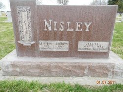
Mary Ethel Harrow Nisley
| Birth | : | 4 Oct 1888 North Platte, Lincoln County, Nebraska, USA |
| Death | : | 7 Jan 1965 Lexington, Dawson County, Nebraska, USA |
| Burial | : | Greenwood Cemetery, Decatur, Macon County, USA |
| Coordinate | : | 39.8319016, -88.9582977 |
frequently asked questions (FAQ):
-
Where is Mary Ethel Harrow Nisley's memorial?
Mary Ethel Harrow Nisley's memorial is located at: Greenwood Cemetery, Decatur, Macon County, USA.
-
When did Mary Ethel Harrow Nisley death?
Mary Ethel Harrow Nisley death on 7 Jan 1965 in Lexington, Dawson County, Nebraska, USA
-
Where are the coordinates of the Mary Ethel Harrow Nisley's memorial?
Latitude: 39.8319016
Longitude: -88.9582977
Family Members:
Parent
Spouse

Siblings

Children
Flowers:


Nearby Cemetories:
1. Greenwood Cemetery
Decatur, Macon County, USA
Coordinate: 39.8319016, -88.9582977
2. Saint Johns Episcopal Church Columbarium
Decatur, Macon County, USA
Coordinate: 39.8461020, -88.9570160
3. Calvary Catholic Cemetery
Decatur, Macon County, USA
Coordinate: 39.8452072, -88.9765015
4. Fairlawn Cemetery
Decatur, Macon County, USA
Coordinate: 39.8488998, -88.9863968
5. Graceland Cemetery
Decatur, Macon County, USA
Coordinate: 39.8616982, -88.9764023
6. Walnut Grove Cemetery
Decatur, Macon County, USA
Coordinate: 39.8033330, -88.9813890
7. Mount Gilead Cemetery
Decatur, Macon County, USA
Coordinate: 39.7891655, -88.9508362
8. Turpin Cemetery
Turpin, Macon County, USA
Coordinate: 39.7941680, -88.9272250
9. Spangler Cemetery
Decatur, Macon County, USA
Coordinate: 39.8511009, -88.8989029
10. Sharon Cemetery
Decatur, Macon County, USA
Coordinate: 39.8431015, -89.0222015
11. South Wheatland Township Cemetery
Decatur, Macon County, USA
Coordinate: 39.7784800, -88.9551560
12. Saint Johns Lutheran Cemetery
Decatur, Macon County, USA
Coordinate: 39.8637886, -88.8975677
13. Salem Cemetery
Decatur, Macon County, USA
Coordinate: 39.7977791, -89.0180588
14. Hays Cemetery
Decatur, Macon County, USA
Coordinate: 39.8888890, -88.9422220
15. Boiling Springs Cemetery
Decatur, Macon County, USA
Coordinate: 39.8838997, -88.9978027
16. North Fork Cemetery
Long Creek, Macon County, USA
Coordinate: 39.8463898, -88.8752747
17. Peach Orchard Cemetery (Defunct)
Decatur, Macon County, USA
Coordinate: 39.8942020, -88.9254740
18. Lester R Barnett Memorial Cemetery
Decatur, Macon County, USA
Coordinate: 39.8511100, -88.8661000
19. Macon County Memorial Park
Harristown, Macon County, USA
Coordinate: 39.8442001, -89.0532990
20. Mount Zion Township Cemetery
Mount Zion, Macon County, USA
Coordinate: 39.7769440, -88.8775000
21. Crum Cemetery
Harristown, Macon County, USA
Coordinate: 39.8266983, -89.0667038
22. Mount Zion Presbyterian Cemetery
Mount Zion, Macon County, USA
Coordinate: 39.7708330, -88.8755560
23. Hudelson Cemetery
Boody, Macon County, USA
Coordinate: 39.7961006, -89.0642014
24. Wheeler Cemetery
Oakley, Macon County, USA
Coordinate: 39.8833008, -88.8581009