
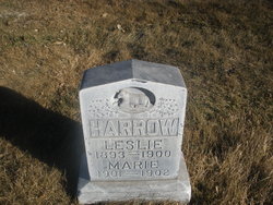
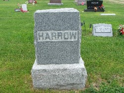
Marie Harrow
| Birth | : | 1901 |
| Death | : | 22 Oct 1902 North Platte, Lincoln County, Nebraska, USA |
| Burial | : | St. Swithin Churchyard, Bath, Bath and North East Somerset Unitary Authority, England |
| Coordinate | : | 51.3885480, -2.3594500 |
| Plot | : | Lot-766-Space-04 |
| Description | : | Buried-Oct 03,1902, per online Cemetery records Lot-766 Space-04 Marie Harrow 1901-Oct 22,1902 Died of Spinal Meningitis The little year and a half old daughter of Mr. and Mrs. Harrow who live in the east part of town died yesterday morning of spinal meningitis. The parents have the sympathy of many friends in the loss of their little one. The funeral service will be conducted by Rev. Randolph at the house tomorrow at 3p.m. The Independent Era, North Platte,Nebraska Oct 23,1902 |
frequently asked questions (FAQ):
-
Where is Marie Harrow's memorial?
Marie Harrow's memorial is located at: St. Swithin Churchyard, Bath, Bath and North East Somerset Unitary Authority, England.
-
When did Marie Harrow death?
Marie Harrow death on 22 Oct 1902 in North Platte, Lincoln County, Nebraska, USA
-
Where are the coordinates of the Marie Harrow's memorial?
Latitude: 51.3885480
Longitude: -2.3594500
Family Members:
Parent
Siblings

Flowers:


Nearby Cemetories:
1. St. Swithin Churchyard
Bath, Bath and North East Somerset Unitary Authority, England
Coordinate: 51.3885480, -2.3594500
2. Walcot Methodist Chapel Burial Ground
Bath, Bath and North East Somerset Unitary Authority, England
Coordinate: 51.3897080, -2.3579610
3. St. John the Baptist Churchyard
Bathwick, Bath and North East Somerset Unitary Authority, England
Coordinate: 51.3886890, -2.3547030
4. St. Mary's Churchyard
Bathwick, Bath and North East Somerset Unitary Authority, England
Coordinate: 51.3876120, -2.3543540
5. St. Michael's Burial Ground
Bath, Bath and North East Somerset Unitary Authority, England
Coordinate: 51.3838810, -2.3594090
6. Ss Michael & Paul Churchyard
Bath, Bath and North East Somerset Unitary Authority, England
Coordinate: 51.3834970, -2.3596980
7. Independent Burial Ground Argyle Chapel
Bath, Bath and North East Somerset Unitary Authority, England
Coordinate: 51.3925420, -2.3536920
8. Bath General Hospital Burial Ground
Bath and North East Somerset Unitary Authority, England
Coordinate: 51.3824715, -2.3614742
9. Quaker Meeting House
Bath, Bath and North East Somerset Unitary Authority, England
Coordinate: 51.3823280, -2.3604380
10. St Mary's Chapel, Queens Square
Bath, Bath and North East Somerset Unitary Authority, England
Coordinate: 51.3827790, -2.3649790
11. Bath Abbey
Bath, Bath and North East Somerset Unitary Authority, England
Coordinate: 51.3815310, -2.3586640
12. St. Mary de Stall Churchyard (Defunct)
Bath, Bath and North East Somerset Unitary Authority, England
Coordinate: 51.3813350, -2.3600353
13. Old Orchard Street Catholic Burial Vault
Bath, Bath and North East Somerset Unitary Authority, England
Coordinate: 51.3800370, -2.3579910
14. St James Old Burial Ground
Bath, Bath and North East Somerset Unitary Authority, England
Coordinate: 51.3798600, -2.3610100
15. St Saviour's Church Crypt
Larkhall, Bath and North East Somerset Unitary Authority, England
Coordinate: 51.3956300, -2.3465100
16. St. James' Cemetery
Bath, Bath and North East Somerset Unitary Authority, England
Coordinate: 51.3802000, -2.3722200
17. Saint Mark's Churchyard
Widcombe, Bath and North East Somerset Unitary Authority, England
Coordinate: 51.3766660, -2.3588010
18. Baptist Burial Ground
Widcombe, Bath and North East Somerset Unitary Authority, England
Coordinate: 51.3764216, -2.3556947
19. Moravian Burial Ground
Bath, Bath and North East Somerset Unitary Authority, England
Coordinate: 51.3894150, -2.3798150
20. St Mary Magdalen Chapel
Widcombe, Bath and North East Somerset Unitary Authority, England
Coordinate: 51.3760486, -2.3643405
21. Old Baptist Burial Ground
Walcot, Bath and North East Somerset Unitary Authority, England
Coordinate: 51.3755070, -2.3544360
22. Abbey & St James' Graveyard for the Poor
Widcombe, Bath and North East Somerset Unitary Authority, England
Coordinate: 51.3753550, -2.3545640
23. St. Michael's Cemetery
Bath, Bath and North East Somerset Unitary Authority, England
Coordinate: 51.3859700, -2.3814500
24. Quaker Burial Ground
Widcombe, Bath and North East Somerset Unitary Authority, England
Coordinate: 51.3744350, -2.3498460