

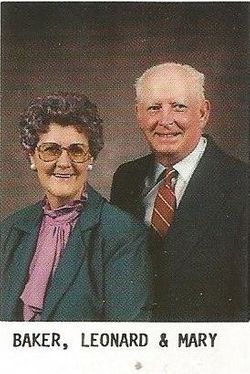
Mary Gene Smotherman Baker
| Birth | : | 6 Feb 1929 Calloway County, Kentucky, USA |
| Death | : | 15 Jan 2015 East Prairie, Mississippi County, Missouri, USA |
| Burial | : | Dogwood Cemetery, Dogwood, Mississippi County, USA |
| Coordinate | : | 36.8231316, -89.4546738 |
| Description | : | MARY GENE SMOTHERMAN BAKER, age 85, a resident of East Prairie died Thursday, January 15, 2015, at the East Prairie Nursing Center. She was born February 6, 1929 in Calloway County, KY to the late James H. and Bessie Wyatt Smotherman. She had lived in East Prairie most of her life where she was a member of the First Baptist Church. She was employed for 42 years with Brown Shoe Company in Charleston until her retirement in 1991. In November 1971 she married Clarence Leonard “C.L.” Baker who survives of the home. Also surviving is one sister, Carmen... Read More |
frequently asked questions (FAQ):
-
Where is Mary Gene Smotherman Baker's memorial?
Mary Gene Smotherman Baker's memorial is located at: Dogwood Cemetery, Dogwood, Mississippi County, USA.
-
When did Mary Gene Smotherman Baker death?
Mary Gene Smotherman Baker death on 15 Jan 2015 in East Prairie, Mississippi County, Missouri, USA
-
Where are the coordinates of the Mary Gene Smotherman Baker's memorial?
Latitude: 36.8231316
Longitude: -89.4546738
Family Members:
Parent
Spouse
Siblings


Flowers:


Nearby Cemetories:
1. Dogwood Cemetery
Dogwood, Mississippi County, USA
Coordinate: 36.8231316, -89.4546738
2. Armer Cemetery
East Prairie, Mississippi County, USA
Coordinate: 36.8703003, -89.4608002
3. Big Opening Cemetery
New Madrid County, USA
Coordinate: 36.8089500, -89.5247100
4. Memorial Park Cemetery
East Prairie, Mississippi County, USA
Coordinate: 36.7837868, -89.3962479
5. Zilafro Cemetery
East Prairie, Mississippi County, USA
Coordinate: 36.7544960, -89.4100550
6. Greer Family Cemetery
Mississippi County, USA
Coordinate: 36.8017967, -89.3569275
7. Harper Cemetery
Mississippi County, USA
Coordinate: 36.7429200, -89.4150000
8. Pryor Cemetery
Mississippi County, USA
Coordinate: 36.7429680, -89.4147530
9. Bright Prospect Cemetery
Miner, Scott County, USA
Coordinate: 36.8844948, -89.5352707
10. Sikes Family Cemetery
Sikeston, New Madrid County, USA
Coordinate: 36.8410380, -89.5697350
11. Anniston Cemetery
Anniston, Mississippi County, USA
Coordinate: 36.8235100, -89.3336500
12. Bloomfield Cemetery
New Madrid County, USA
Coordinate: 36.7453003, -89.5382996
13. Calvary Cemetery
Charleston, Mississippi County, USA
Coordinate: 36.9212200, -89.3864000
14. Sikeston Memorial Park
Sikeston, New Madrid County, USA
Coordinate: 36.8630981, -89.5867004
15. Oak Grove Cemetery
Charleston, Mississippi County, USA
Coordinate: 36.9227982, -89.3858032
16. Sikeston City Cemetery
Sikeston, Scott County, USA
Coordinate: 36.8696442, -89.5867538
17. Dalton Cemetery
Charleston, Mississippi County, USA
Coordinate: 36.8698880, -89.3194700
18. Hart Cemetery
Miner, Scott County, USA
Coordinate: 36.8986015, -89.5721970
19. Calhoun Cemetery
Mississippi County, USA
Coordinate: 36.7672005, -89.3191986
20. Pulltight Cemetery
Pulltight, Mississippi County, USA
Coordinate: 36.7796300, -89.3108600
21. Matthews Cemetery
Matthews, New Madrid County, USA
Coordinate: 36.7496986, -89.5817032
22. Garden Of Memories Cemetery
Sikeston, Scott County, USA
Coordinate: 36.8650017, -89.6035995
23. Pleasant Valley Cemetery
Sikeston, Scott County, USA
Coordinate: 36.9418983, -89.5132980
24. Hunter Memorial Cemetery
Sikeston, Scott County, USA
Coordinate: 36.8844200, -89.5952800