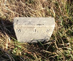
Mary J. Carter Ford
| Birth | : | 18 Nov 1826 Devon, England |
| Death | : | 23 Jan 1899 Axtell, Marshall County, Kansas, USA |
| Burial | : | Shockleys Fairland Cemetery, Marshall County, USA |
| Coordinate | : | 39.9284500, -96.2866500 |
| Plot | : | 49 |
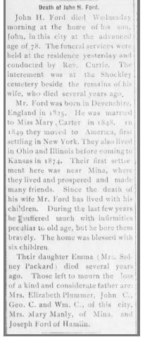
| Description | : | Mrs. John H. Ford, whose maiden name was Mary Carter, was born in England in the 1827. She died at the old homestead near Fairview school house, January 22, 1899, aged 72 years and 2 months. In 1849, just fifty years ago, Miss Carter was married to J. H. Ford and the same year came to this country and located in the state of New York. In 1870, Mr. and Mrs Ford came to Kansas which has since been their home. They raised a family of sons and daughters, who are well known in this... Read More |
frequently asked questions (FAQ):
-
Where is Mary J. Carter Ford's memorial?
Mary J. Carter Ford's memorial is located at: Shockleys Fairland Cemetery, Marshall County, USA.
-
When did Mary J. Carter Ford death?
Mary J. Carter Ford death on 23 Jan 1899 in Axtell, Marshall County, Kansas, USA
-
Where are the coordinates of the Mary J. Carter Ford's memorial?
Latitude: 39.9284500
Longitude: -96.2866500
Family Members:
Spouse
Children
Flowers:
Nearby Cemetories:
1. Shockleys Fairland Cemetery
Marshall County, USA
Coordinate: 39.9284500, -96.2866500
2. Saint Bridget Cemetery
Axtell, Marshall County, USA
Coordinate: 39.9572000, -96.2578000
3. Saint Michaels Cemetery
Axtell, Marshall County, USA
Coordinate: 39.8922005, -96.2577972
4. Rose Hill Cemetery
Axtell, Marshall County, USA
Coordinate: 39.8793983, -96.2667007
5. Madden Cemetery
Axtell, Marshall County, USA
Coordinate: 39.9866800, -96.2490300
6. Ash Point Cemetery
Baileyville, Nemaha County, USA
Coordinate: 39.8962380, -96.2051080
7. Holy Family Cemetery
Summerfield, Marshall County, USA
Coordinate: 39.9994011, -96.3414001
8. Summerfield Cemetery
Summerfield, Marshall County, USA
Coordinate: 40.0005989, -96.3422012
9. Brewer Cemetery
Baileyville, Nemaha County, USA
Coordinate: 39.9556900, -96.1736500
10. Richland Center Cemetery
Marshall County, USA
Coordinate: 39.9584000, -96.4073700
11. Guittard Cemetery
Beattie, Marshall County, USA
Coordinate: 39.9094009, -96.4152985
12. Johnson Creek Cemetery
Pawnee City, Pawnee County, USA
Coordinate: 40.0270000, -96.2465000
13. Mission Covenant Cemetery
Marshall County, USA
Coordinate: 39.8269005, -96.3153000
14. Baileyville Cemetery
Baileyville, Nemaha County, USA
Coordinate: 39.8418900, -96.1976300
15. Sacred Heart Cemetery
Baileyville, Nemaha County, USA
Coordinate: 39.8485985, -96.1832962
16. Beattie Union Cemetery
Beattie, Marshall County, USA
Coordinate: 39.8717003, -96.4207993
17. McCaffrey Cemetery
Nemaha County, USA
Coordinate: 39.9827100, -96.1474500
18. Saint Patricks Cemetery
Beattie, Marshall County, USA
Coordinate: 39.8703003, -96.4231033
19. Salem Lutheran Cemetery
Axtell, Marshall County, USA
Coordinate: 39.7990200, -96.3352200
20. Pleasant Ridge Cemetery
Du Bois, Pawnee County, USA
Coordinate: 40.0156000, -96.1494000
21. Tanner Cemetery
Pawnee County, USA
Coordinate: 40.0238991, -96.4143982
22. Mission Creek Cemetery
Pawnee County, USA
Coordinate: 40.0149994, -96.4263992
23. Pleasant Valley Cemetery
Pawnee County, USA
Coordinate: 40.0299988, -96.1554794
24. Mission Creek Cemetery
Marshall County, USA
Coordinate: 39.9866982, -96.4649963


