
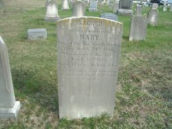
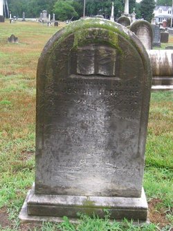
Mary Jackson Heritage
| Birth | : | 24 Mar 1780 New Jersey, USA |
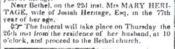
| Death | : | 22 Mar 1857 Hurffville, Gloucester County, New Jersey, USA |
| Burial | : | Woodstock Presbyterian Cemetery, Woodstock, Oxford County Municipality, Canada |
| Coordinate | : | 43.1409440, -80.7651600 |
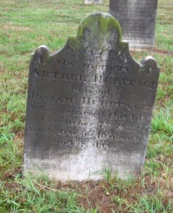
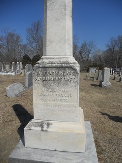
| Inscription | : | SACRED to the memory of MARY, Wife of the Rev. Josiah Heritage Born March 24th 1780 Who departed this life March 22nd 1857 Aged 77 years lacking 2 days And like Mary of old had c |
| Description | : | Mary was the daughter of Joseph Jackson and Ann Shute. She married Josiah Heritage on 25 Dec. 1799 (source needed). She died near Bethel (Hurffville), Gloucester Co., NJ. Note: Mary's name is frequently shown as "Mary Ann" in online trees. This seems to be incorrect, as no documentation of a middle name or initial has been found, and she had an older sister named Ann. Heartfelt thanks to William Ridge for creating this memorial and the gravestone image. |
frequently asked questions (FAQ):
-
Where is Mary Jackson Heritage's memorial?
Mary Jackson Heritage's memorial is located at: Woodstock Presbyterian Cemetery, Woodstock, Oxford County Municipality, Canada.
-
When did Mary Jackson Heritage death?
Mary Jackson Heritage death on 22 Mar 1857 in Hurffville, Gloucester County, New Jersey, USA
-
Where are the coordinates of the Mary Jackson Heritage's memorial?
Latitude: 43.1409440
Longitude: -80.7651600
Family Members:
Parent
Spouse
Siblings

Children
Flowers:


Nearby Cemetories:
1. Woodstock Presbyterian Cemetery
Woodstock, Oxford County Municipality, Canada
Coordinate: 43.1409440, -80.7651600
2. Woodstock Baptist Cemetery
Woodstock, Oxford County Municipality, Canada
Coordinate: 43.1416460, -80.7655790
3. Anglican Cemetery
Woodstock, Oxford County Municipality, Canada
Coordinate: 43.1426000, -80.7653300
4. Old St. Paul's Anglican Cemetery
Woodstock, Oxford County Municipality, Canada
Coordinate: 43.1325600, -80.7462300
5. House of Refuge Cemetery
Woodstock, Oxford County Municipality, Canada
Coordinate: 43.1476245, -80.7873872
6. Hillview Cemetery
Woodstock, Oxford County Municipality, Canada
Coordinate: 43.1206703, -80.7675400
7. Saint Marys Roman Catholic Cemetery
Woodstock, Oxford County Municipality, Canada
Coordinate: 43.1089400, -80.7998900
8. Oxford Memorial Park Cemetery
Woodstock, Oxford County Municipality, Canada
Coordinate: 43.1148200, -80.8150400
9. Huntingford Christ Church Anglican Cemetery
Huntingford, Oxford County Municipality, Canada
Coordinate: 43.2000280, -80.7960970
10. Vandecar Cemetery
Vandecar, Oxford County Municipality, Canada
Coordinate: 43.2010640, -80.8148020
11. Beachville Cemetery
Beachville, Oxford County Municipality, Canada
Coordinate: 43.0889511, -80.8313599
12. Sweaburg Union Cemetery
Sweaburg, Oxford County Municipality, Canada
Coordinate: 43.0690800, -80.7623200
13. Old Log Church Cemetery
Embro, Oxford County Municipality, Canada
Coordinate: 43.1529121, -80.8626785
14. Oxford Centre Christ Church Anglican Cemetery
Oxford Centre, Oxford County Municipality, Canada
Coordinate: 43.0996310, -80.6814490
15. East Oxford Pioneer Cemetery
Oxford Centre, Oxford County Municipality, Canada
Coordinate: 43.0999370, -80.6804350
16. Pleasant View Cemetery
Curries, Oxford County Municipality, Canada
Coordinate: 43.0716390, -80.7196470
17. Saint Johns Anglican Cemetery
Eastwood, Oxford County Municipality, Canada
Coordinate: 43.1443080, -80.6575850
18. Innerkip Cemetery
Innerkip, Oxford County Municipality, Canada
Coordinate: 43.2050000, -80.6929000
19. Methodist Cemetery
Embro, Oxford County Municipality, Canada
Coordinate: 43.1495018, -80.8983841
20. North Embro Cemetery
Embro, Oxford County Municipality, Canada
Coordinate: 43.1667920, -80.9040350
21. West Oxford United Church Cemetery
Centreville, Oxford County Municipality, Canada
Coordinate: 43.0521710, -80.8451320
22. Ingersoll Rural Cemetery
Ingersoll, Oxford County Municipality, Canada
Coordinate: 43.0545040, -80.8732690
23. Zion Oriel Cemetery
Oriel, Oxford County Municipality, Canada
Coordinate: 43.0650630, -80.6425670
24. Red Star Cemetery
Embro, Oxford County Municipality, Canada
Coordinate: 43.1124175, -80.9326897