
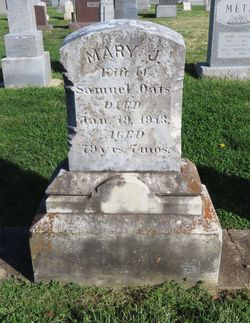


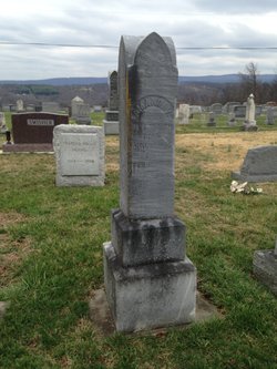
Mary Jane Noel Oats
| Birth | : | 19 Jun 1833 West Virginia, USA |
| Death | : | 19 Jan 1913 West Virginia, USA |
| Burial | : | Johnson Cemetery, Presque Isle, Aroostook County, USA |
| Coordinate | : | 46.7078209, -68.0069733 |
| Inscription | : | w/o Samuel Oats -- Aged 79 years, 7 months |
frequently asked questions (FAQ):
-
Where is Mary Jane Noel Oats's memorial?
Mary Jane Noel Oats's memorial is located at: Johnson Cemetery, Presque Isle, Aroostook County, USA.
-
When did Mary Jane Noel Oats death?
Mary Jane Noel Oats death on 19 Jan 1913 in West Virginia, USA
-
Where are the coordinates of the Mary Jane Noel Oats's memorial?
Latitude: 46.7078209
Longitude: -68.0069733
Family Members:
Spouse
Children

Flowers:


Nearby Cemetories:
1. Johnson Cemetery
Presque Isle, Aroostook County, USA
Coordinate: 46.7078209, -68.0069733
2. Saint Marys Cemetery
Presque Isle, Aroostook County, USA
Coordinate: 46.6930930, -68.0104730
3. Saint Marys Chapman Street Cemetery
Presque Isle, Aroostook County, USA
Coordinate: 46.6754150, -68.0215990
4. Bartlett Cemetery
Presque Isle, Aroostook County, USA
Coordinate: 46.6765327, -67.9827118
5. Reuben Bean Family Cemetery
Aroostook County, USA
Coordinate: 46.7141610, -67.9514610
6. Fairmount Cemetery
Presque Isle, Aroostook County, USA
Coordinate: 46.6628075, -68.0077744
7. Bean Family Cemetery
Aroostook County, USA
Coordinate: 46.7396440, -67.9542600
8. Hillside Grove Cemetery
Crouseville, Aroostook County, USA
Coordinate: 46.7566760, -68.0765500
9. Crouseville Cemetery
Crouseville, Aroostook County, USA
Coordinate: 46.7574997, -68.0768967
10. Estes Park Cemetery
Easton, Aroostook County, USA
Coordinate: 46.6418110, -67.9181820
11. Knight Cemetery
Fort Fairfield, Aroostook County, USA
Coordinate: 46.6876150, -67.8778140
12. Lyndon Center Cemetery
Caribou, Aroostook County, USA
Coordinate: 46.8022240, -67.9921920
13. Haines Maple Grove Cemetery
Fort Fairfield, Aroostook County, USA
Coordinate: 46.7233160, -67.8699040
14. Pine Tree Cemetery
Easton, Aroostook County, USA
Coordinate: 46.6774640, -67.8727940
15. Greenridge Cemetery
Caribou, Aroostook County, USA
Coordinate: 46.7923622, -67.9321976
16. Thompson Burial Ground
Caribou, Aroostook County, USA
Coordinate: 46.8143280, -67.9821140
17. Union Cemetery
Fort Fairfield, Aroostook County, USA
Coordinate: 46.7566150, -67.8655240
18. Harvey Hill Cemetery
McShea, Aroostook County, USA
Coordinate: 46.7567099, -67.8652997
19. Old Mill Town Cemetery
Mapleton, Aroostook County, USA
Coordinate: 46.6815700, -68.1609100
20. Grendell Cemetery
Chapman, Aroostook County, USA
Coordinate: 46.6364010, -68.1318340
21. Southside Cemetery
Mapleton, Aroostook County, USA
Coordinate: 46.6622050, -68.1633620
22. Mount Shiloh Cemetery
Easton, Aroostook County, USA
Coordinate: 46.6362460, -67.8670810
23. Washburn Riverside Extension Cemetery
Washburn, Aroostook County, USA
Coordinate: 46.7750816, -68.1517105
24. Castle Hill Cemetery
Castle Hill, Aroostook County, USA
Coordinate: 46.7346840, -68.1792210