
| Birth | : | 20 Dec 1920 Platte County, Nebraska, USA |
| Death | : | 30 Dec 2005 Orange County, California, USA |
| Burial | : | Calvary Cemetery, Omaha, Douglas County, USA |
| Coordinate | : | 41.2364006, -96.0294037 |
| Plot | : | Chapel Of The Apostles Maus |
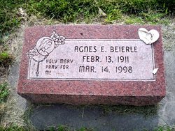
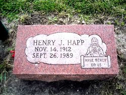
| Description | : | Obituary (Omaha (NE) World-Herald, Jan. 11, 2006)- Mary Joe Happ, age 85, of Omaha. Died December 30, 2005. Preceded in death by sisters, Mickie McChane and Agnes Beierle, and brothers, Clarence Happ, Henry Happ, and Bob Happ. Survived by sister, Irene Cornwell, of Blair. Also survived by 11 nieces and nephews, several grandnieces and nephews, and many friends in Omaha and Yorba Linda, California. Mary Joe graduated from Lindsay Holy Family High School. Mary Joe was a caterer for the Sheraton Fontenelle Hotel in downtown Omaha for many years, and a long-time member of the American Legion Auxiliary and the... Read More |
frequently asked questions (FAQ):
-
Where is Mary Joe Elizabeth Happ's memorial?
Mary Joe Elizabeth Happ's memorial is located at: Calvary Cemetery, Omaha, Douglas County, USA.
-
When did Mary Joe Elizabeth Happ death?
Mary Joe Elizabeth Happ death on 30 Dec 2005 in Orange County, California, USA
-
Where are the coordinates of the Mary Joe Elizabeth Happ's memorial?
Latitude: 41.2364006
Longitude: -96.0294037
Family Members:
Parent
Siblings

Flowers:


Nearby Cemetories:
1. Calvary Cemetery
Omaha, Douglas County, USA
Coordinate: 41.2364006, -96.0294037
2. Evergreen Memorial Park Cemetery
Omaha, Douglas County, USA
Coordinate: 41.2393990, -96.0355988
3. Resurrection Cemetery
Omaha, Douglas County, USA
Coordinate: 41.2344208, -96.0365448
4. Ak-Sar-Ben Racetrack Grounds
Omaha, Douglas County, USA
Coordinate: 41.2414703, -96.0159607
5. Saint Andrews Episcopal Church Columbarium
Omaha, Douglas County, USA
Coordinate: 41.2492500, -96.0427500
6. Countryside Community Church Columbarium
Omaha, Douglas County, USA
Coordinate: 41.2483660, -96.0500270
7. Westlawn-Hillcrest Memorial Park
Omaha, Douglas County, USA
Coordinate: 41.2346992, -95.9966965
8. Bohemian Cemetery
Omaha, Douglas County, USA
Coordinate: 41.2388992, -95.9955978
9. Beth El Cemetery
Ralston, Douglas County, USA
Coordinate: 41.2117004, -96.0428009
10. Holy Sepulchre Cemetery
Omaha, Douglas County, USA
Coordinate: 41.2543983, -95.9875031
11. Douglas County Poor Farm Cemetery
Omaha, Douglas County, USA
Coordinate: 41.2437240, -95.9723480
12. Graceland Park Cemetery
Omaha, Douglas County, USA
Coordinate: 41.2113991, -95.9785995
13. Saint Mary Magdalene Cemetery
Omaha, Douglas County, USA
Coordinate: 41.2039420, -95.9850610
14. All Saints Episcopal Church Columbarium
Omaha, Douglas County, USA
Coordinate: 41.2785000, -96.0579000
15. First Central Congregational Columbarium
Omaha, Douglas County, USA
Coordinate: 41.2563456, -95.9658365
16. Nash Chapel Crypt
Omaha, Douglas County, USA
Coordinate: 41.2665090, -95.9721790
17. Saint Mary's Cemetery
Omaha, Douglas County, USA
Coordinate: 41.2042007, -95.9646988
18. Papillion Cemetery
Papillion, Sarpy County, USA
Coordinate: 41.1758003, -96.0410995
19. Portal Cemetery
Sarpy County, USA
Coordinate: 41.1838989, -96.0802994
20. Servants of Mary Cemetery
Omaha, Douglas County, USA
Coordinate: 41.3017170, -96.0258260
21. Prospect Hill Cemetery
Omaha, Douglas County, USA
Coordinate: 41.2780991, -95.9593964
22. Mount Hope Cemetery
Omaha, Douglas County, USA
Coordinate: 41.3041992, -96.0310974
23. Saint Johns Cemetery
Bellevue, Sarpy County, USA
Coordinate: 41.1864014, -95.9682999
24. Pleasant Hill Cemetery
Omaha, Douglas County, USA
Coordinate: 41.2558975, -96.1194687