
| Birth | : | 17 Jun 1861 Surry County, North Carolina, USA |
| Death | : | 24 Dec 1910 Yakima County, Washington, USA |
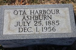
| Burial | : | Lower Valley Memorial Gardens, Sunnyside, Yakima County, USA |
| Coordinate | : | 46.3450012, -120.0117035 |
| Plot | : | Old section across the road, Block C, Lot 19, Grave 3 |
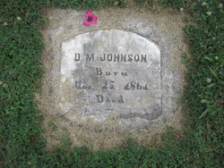
| Inscription | : | Wife of D.M. Johnson |
| Description | : | Mary married Dock Martin Johnson in Surry County, NC on 11/1/1883 per Surry marriage book C, page 2066. She was a daughter of Moses Green Harbour and Martha Susan Joyce who married in Patrick County, VA on 12/2/1856 _______________________________ 1900 United States Federal Census Eldora, Surry Co., North Carolina Household Members: Doc M. Johnson 39 -Head Mar 1861 NC -Farmer Mary Johnson 39 -Wife Jun 1861 NC *** Dallas N. Johnson 15 -Son Aug 1884 NC Tommas E. Johnson 13 -Son Oct 1886 NC Albert H. Johnson 11 -Son Sep 1888 NC |
frequently asked questions (FAQ):
-
Where is Mary L Harbour Johnson's memorial?
Mary L Harbour Johnson's memorial is located at: Lower Valley Memorial Gardens, Sunnyside, Yakima County, USA.
-
When did Mary L Harbour Johnson death?
Mary L Harbour Johnson death on 24 Dec 1910 in Yakima County, Washington, USA
-
Where are the coordinates of the Mary L Harbour Johnson's memorial?
Latitude: 46.3450012
Longitude: -120.0117035
Family Members:
Parent
Spouse
Siblings
Children

Flowers:


Nearby Cemetories:
1. Lower Valley Memorial Gardens
Sunnyside, Yakima County, USA
Coordinate: 46.3450012, -120.0117035
2. Holy Trinity Episcopal Close
Sunnyside, Yakima County, USA
Coordinate: 46.3235000, -120.0158500
3. Outlook Cemetery
Yakima, Yakima County, USA
Coordinate: 46.3208008, -120.0811005
4. Grandview Cemetery
Grandview, Yakima County, USA
Coordinate: 46.2658005, -119.8902969
5. Mabton Cemetery
Mabton, Yakima County, USA
Coordinate: 46.2285995, -119.9852982
6. Smohalla Cemetery
Toppenish, Yakima County, USA
Coordinate: 46.3009660, -120.2186250
7. Black Rock Cemetery
Moxee City, Yakima County, USA
Coordinate: 46.5111084, -119.9985962
8. Zillah German Baptist Cemetery
Zillah, Yakima County, USA
Coordinate: 46.4128550, -120.2506400
9. McCoy Cemetery
Toppenish, Yakima County, USA
Coordinate: 46.3835983, -120.2755966
10. Zillah Cemetery
Zillah, Yakima County, USA
Coordinate: 46.4055202, -120.2726072
11. Prosser Pioneer Cemetery
Prosser, Benton County, USA
Coordinate: 46.1947937, -119.8095245
12. Winnier Cemetery
Toppenish, Yakima County, USA
Coordinate: 46.3590060, -120.3192450
13. Elmwood Cemetery
Toppenish, Yakima County, USA
Coordinate: 46.3673830, -120.3334530
14. Prosser Cemetery
Prosser, Benton County, USA
Coordinate: 46.2047539, -119.7541504
15. Glade Cemetery
Yakima County, USA
Coordinate: 46.0778008, -120.0914001
16. Smina Cemetery
Yakima County, USA
Coordinate: 46.2372017, -120.4269028
17. Beaver Cemetery
Yakima County, USA
Coordinate: 46.0993996, -120.2866974
18. Holy Rosary Cemetery
Moxee City, Yakima County, USA
Coordinate: 46.5531006, -120.3585968
19. Holland Cemetery
Moxee City, Yakima County, USA
Coordinate: 46.5766983, -120.3861008
20. Meninick Cemetery
Yakima County, USA
Coordinate: 46.1981010, -120.4741974
21. Evergreen Cemetery
Benton City, Benton County, USA
Coordinate: 46.2867012, -119.4938965
22. Union Gap Cemetery
Yakima County, USA
Coordinate: 46.5209084, -120.4850998
23. Reservation Community Memorial Park
Wapato, Yakima County, USA
Coordinate: 46.4484291, -120.5375519
24. Toweatmy Cemetery
Toppenish, Yakima County, USA
Coordinate: 46.1794014, -120.5056000