

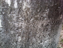

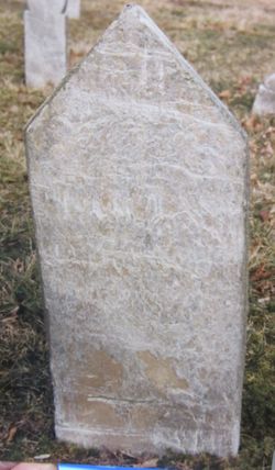
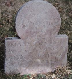
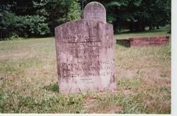
Mary Lane Coble
| Birth | : | 4 Jan 1799 Randolph County, North Carolina, USA |
| Death | : | 9 Oct 1884 Randolph County, North Carolina, USA |
| Burial | : | Richland Cemetery, Liberty, Randolph County, USA |
| Coordinate | : | 35.8996315, -79.5469894 |
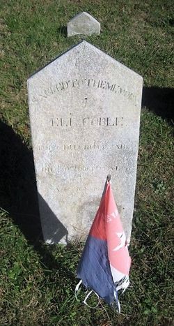
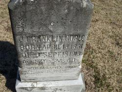
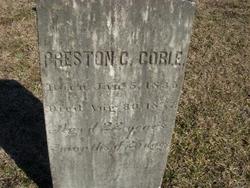
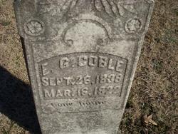
| Description | : | --Children: James Franklin "Frank" Coble (Find A Grave Memorial# 33738955) Preston Clay Coble (Find A Grave Memorial# 33746995) Eli Graham Coble (Find A Grave Memorial# 33739178) |
frequently asked questions (FAQ):
-
Where is Mary Lane Coble's memorial?
Mary Lane Coble's memorial is located at: Richland Cemetery, Liberty, Randolph County, USA.
-
When did Mary Lane Coble death?
Mary Lane Coble death on 9 Oct 1884 in Randolph County, North Carolina, USA
-
Where are the coordinates of the Mary Lane Coble's memorial?
Latitude: 35.8996315
Longitude: -79.5469894
Family Members:
Parent
Spouse
Siblings

Children
Flowers:


Nearby Cemetories:
1. Richland Cemetery
Liberty, Randolph County, USA
Coordinate: 35.8996315, -79.5469894
2. Smithwood United Church of Christ Cemetery
Guilford County, USA
Coordinate: 35.9113900, -79.5605600
3. Oak Grove Baptist Church Cemetery
Snow Camp, Alamance County, USA
Coordinate: 35.8873490, -79.5330180
4. Liberty Grove Methodist Church Cemetery
Liberty, Randolph County, USA
Coordinate: 35.8733140, -79.5709950
5. Mount Zion Baptist Church Cemetery
Kimesville, Alamance County, USA
Coordinate: 35.9300003, -79.5198975
6. Pleasant Union Pilgrim Holiness Church Cemetery
Snow Camp, Alamance County, USA
Coordinate: 35.8781350, -79.5011080
7. Beulah United Church of Christ Cemetery
Liberty, Randolph County, USA
Coordinate: 35.9381666, -79.5825583
8. Macedonia Baptist Church Cemetery
Liberty, Randolph County, USA
Coordinate: 35.8960090, -79.6075490
9. Mount Pleasant United Methodist Cemetery
Guilford County, USA
Coordinate: 35.9500140, -79.5525970
10. Fairview Cemetery
Liberty, Randolph County, USA
Coordinate: 35.8516998, -79.5761032
11. Saint Stephen Memorial Gardens
Liberty, Randolph County, USA
Coordinate: 35.8550750, -79.5877970
12. Amos Grove Cemetery
Liberty, Randolph County, USA
Coordinate: 35.8546982, -79.5871964
13. Pleasant Hill Christian Church Cemetery
Pleasant Hill, Alamance County, USA
Coordinate: 35.8725000, -79.4827000
14. Rock Creek Methodist Church Cemetery
Snow Camp, Alamance County, USA
Coordinate: 35.9192900, -79.4776400
15. Rock Creek AME Church Cemetery
Snow Camp, Alamance County, USA
Coordinate: 35.9304930, -79.4836980
16. Hickory Grove Methodist Church Cemetery
Albright Township, Chatham County, USA
Coordinate: 35.8407560, -79.5217650
17. Pleasant Union Methodist Church Cemetery
Julian, Guilford County, USA
Coordinate: 35.9323700, -79.6154700
18. Bethany United Methodist Church Cemetery #2
Liberty, Randolph County, USA
Coordinate: 35.8430060, -79.5948160
19. Cane Creek Monthly Meeting Cemetery
Snow Camp, Alamance County, USA
Coordinate: 35.8894005, -79.4458008
20. Flint Ridge Church Cemetery
Chatham County, USA
Coordinate: 35.8427220, -79.4718840
21. Lows Lutheran Church Cemetery
Whitsett, Guilford County, USA
Coordinate: 35.9876361, -79.5525230
22. Mount Pleasant Baptist Church Cemetery
Staley, Randolph County, USA
Coordinate: 35.8144700, -79.5790000
23. Margarets Chapel Church Cemetery
Staley, Randolph County, USA
Coordinate: 35.8110940, -79.5648900
24. Rocky River Baptist Church Cemetery
Crutchfield Crossroads, Chatham County, USA
Coordinate: 35.8222237, -79.4875031