
| Birth | : | 1788 Randolph County, North Carolina, USA |
| Death | : | 31 Jan 1836 |
| Burial | : | Bethany United Methodist Church Cemetery #2, Liberty, Randolph County, USA |
| Coordinate | : | 35.8430060, -79.5948160 |
| Plot | : | Row 35, Plot 13 |
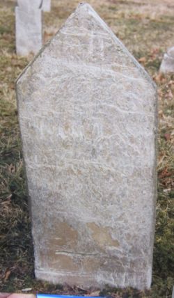
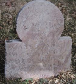
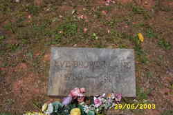
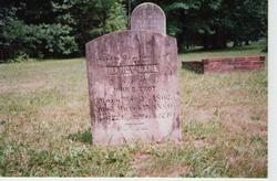
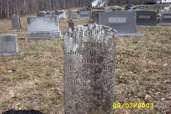
| Description | : | John LANE is the second child of eight children born to Isaac LANE, Sheriff and his wife Mary Wood. John LANE age twenty one married on 14 Sept 1809 to Eve BROWER age nineteen in Randolph County, North Carolina. According to the 1984 book "Christian Brower and Allied Families" John Lane had developed some disturbing personal life styles. "Eve Brower divorced John Lane in 1829, charging that..."John Lane was a habitual drunkard and spendthrift and wasted his substance to the impoverishment of the family..." The three known children of John LANE and Eve BROWER are: 1. Isaac Brower LANE, b. 1810 NC; d.... Read More |
frequently asked questions (FAQ):
-
Where is John Lane's memorial?
John Lane's memorial is located at: Bethany United Methodist Church Cemetery #2, Liberty, Randolph County, USA.
-
When did John Lane death?
John Lane death on 31 Jan 1836 in
-
Where are the coordinates of the John Lane's memorial?
Latitude: 35.8430060
Longitude: -79.5948160
Family Members:
Parent
Spouse
Siblings


Children
Flowers:


Nearby Cemetories:
1. Bethany United Methodist Church Cemetery #2
Liberty, Randolph County, USA
Coordinate: 35.8430060, -79.5948160
2. Amos Grove Cemetery
Liberty, Randolph County, USA
Coordinate: 35.8546982, -79.5871964
3. Saint Stephen Memorial Gardens
Liberty, Randolph County, USA
Coordinate: 35.8550750, -79.5877970
4. Fairview Cemetery
Liberty, Randolph County, USA
Coordinate: 35.8516998, -79.5761032
5. Mount Pleasant Baptist Church Cemetery
Staley, Randolph County, USA
Coordinate: 35.8144700, -79.5790000
6. Liberty Grove Methodist Church Cemetery
Liberty, Randolph County, USA
Coordinate: 35.8733140, -79.5709950
7. McMasters Cemetery
Randolph County, USA
Coordinate: 35.8072370, -79.6021500
8. Melanchthon Lutheran Church Cemetery
Liberty, Randolph County, USA
Coordinate: 35.8451630, -79.6440640
9. Margarets Chapel Church Cemetery
Staley, Randolph County, USA
Coordinate: 35.8110940, -79.5648900
10. Sandy Creek Primitive Baptist Church Cemetery
Liberty, Randolph County, USA
Coordinate: 35.8239020, -79.6406560
11. Sandy Creek Baptist Church Cemetery
Liberty, Randolph County, USA
Coordinate: 35.8235550, -79.6429050
12. Olivers Chapel Cemetery
Staley, Randolph County, USA
Coordinate: 35.8060989, -79.5610962
13. Macedonia Baptist Church Cemetery
Liberty, Randolph County, USA
Coordinate: 35.8960090, -79.6075490
14. Lineberry Family Cemetery
Staley, Randolph County, USA
Coordinate: 35.7878000, -79.5724000
15. Old Shady Grove Cemetery
Staley, Randolph County, USA
Coordinate: 35.7874985, -79.5725021
16. Shady Grove Baptist Church Cemetery
Staley, Randolph County, USA
Coordinate: 35.7853800, -79.5821020
17. Hickory Grove Methodist Church Cemetery
Albright Township, Chatham County, USA
Coordinate: 35.8407560, -79.5217650
18. Hollys Chapel Pentecostal Holiness Church
Ramseur, Randolph County, USA
Coordinate: 35.7825600, -79.6048200
19. Staley City Cemetery
Staley, Randolph County, USA
Coordinate: 35.7918300, -79.5507100
20. Oak Grove Baptist Church Cemetery
Snow Camp, Alamance County, USA
Coordinate: 35.8873490, -79.5330180
21. Richland Cemetery
Liberty, Randolph County, USA
Coordinate: 35.8996315, -79.5469894
22. Whites Chapel United Methodist Church Cemetery
Liberty, Randolph County, USA
Coordinate: 35.7850520, -79.6422990
23. Shiloh United Methodist Church Cemetery
Liberty, Randolph County, USA
Coordinate: 35.8915430, -79.6594990
24. Smithwood United Church of Christ Cemetery
Guilford County, USA
Coordinate: 35.9113900, -79.5605600