
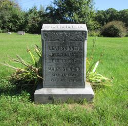
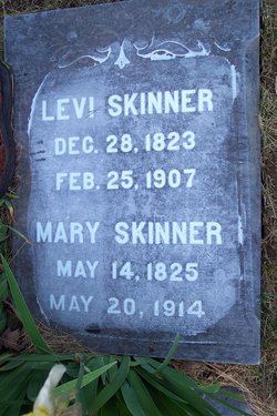
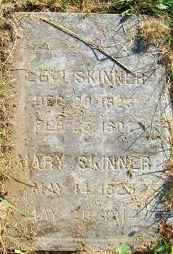
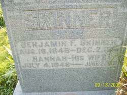
Mary Laughlin Skinner
| Birth | : | 14 May 1825 Delaware, USA |
| Death | : | 20 May 1914 Wapello County, Iowa, USA |
| Burial | : | Holy Innocents Churchyard, Foulsham, Broadland District, England |
| Coordinate | : | 52.7848400, 1.0121600 |
| Description | : | Row 4 # 4 SS Levi |
frequently asked questions (FAQ):
-
Where is Mary Laughlin Skinner's memorial?
Mary Laughlin Skinner's memorial is located at: Holy Innocents Churchyard, Foulsham, Broadland District, England.
-
When did Mary Laughlin Skinner death?
Mary Laughlin Skinner death on 20 May 1914 in Wapello County, Iowa, USA
-
Where are the coordinates of the Mary Laughlin Skinner's memorial?
Latitude: 52.7848400
Longitude: 1.0121600
Family Members:
Spouse

Children

Flowers:


Nearby Cemetories:
1. Holy Innocents Churchyard
Foulsham, Broadland District, England
Coordinate: 52.7848400, 1.0121600
2. St Swithun's Churchyard
Bintree, Breckland Borough, England
Coordinate: 52.7709594, 0.9886811
3. St. Andrews Churchyard
Guist, Breckland Borough, England
Coordinate: 52.7908600, 0.9650200
4. St Peter
Guestwick, Broadland District, England
Coordinate: 52.8014270, 1.0565010
5. Old St. George Churchyard
Hindolveston, North Norfolk District, England
Coordinate: 52.8233900, 1.0136710
6. All Saints Churchyard
Bawdeswell, Breckland Borough, England
Coordinate: 52.7469490, 1.0307670
7. Bawdeswell Cemetery
Bawdeswell, Breckland Borough, England
Coordinate: 52.7446450, 1.0328570
8. St. Peter's Churchyard
Billingford, Breckland Borough, England
Coordinate: 52.7443680, 0.9812590
9. St. Mary the Virgin Churchyard
North Elmham, Breckland Borough, England
Coordinate: 52.7546410, 0.9443500
10. St. Andrew's Churchyard
Wood Dalling, Broadland District, England
Coordinate: 52.8001170, 1.0985350
11. St. Mary's Churchyard
Fulmodeston, North Norfolk District, England
Coordinate: 52.8306490, 0.9558700
12. St. Mary's Churchyard
Sparham, Breckland Borough, England
Coordinate: 52.7349340, 1.0661850
13. St Mary's Churchyard
Bylaugh, Breckland Borough, England
Coordinate: 52.7245880, 1.0136460
14. St Peter's Churchyard
Melton Constable, North Norfolk District, England
Coordinate: 52.8462900, 1.0247300
15. All Saints Churchyard (Ruins)
Ryburgh, North Norfolk District, England
Coordinate: 52.8105000, 0.9181000
16. Christ Church Churchyard
Fulmodeston, North Norfolk District, England
Coordinate: 52.8385680, 0.9569670
17. Reepham Cemetery
Reepham, Broadland District, England
Coordinate: 52.7595078, 1.1082559
18. All Saints Churchyard, Hackford
Reepham, Broadland District, England
Coordinate: 52.7622480, 1.1122220
19. St. Mary's Churchyard
Reepham, Broadland District, England
Coordinate: 52.7623070, 1.1128810
20. St. Andrew's Churchyard
Great Ryburgh, North Norfolk District, England
Coordinate: 52.8072980, 0.9094190
21. St. John the Baptist Chapelyard
Fulmodeston, North Norfolk District, England
Coordinate: 52.8397799, 0.9440578
22. St. Peter and St. Paul's Churchyard
Salle, Broadland District, England
Coordinate: 52.7802370, 1.1276420
23. All Saints Churchyard
Briston, North Norfolk District, England
Coordinate: 52.8511120, 1.0617870
24. Lyng, St. Margaret.
Lyng, Breckland Borough, England
Coordinate: 52.7185190, 1.0619570