

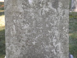
Mary Parker Howe
| Birth | : | 19 May 1763 Shrewsbury, Worcester County, Massachusetts, USA |
| Death | : | 23 Aug 1843 Shrewsbury, Worcester County, Massachusetts, USA |
| Burial | : | Saronville United Methodist Cemetery, Saronville, Clay County, USA |
| Coordinate | : | 40.6147100, -97.9188500 |
| Plot | : | Section 5 |
| Description | : | Age: 80 Spouse: Nathan Howe (d.1851) |
frequently asked questions (FAQ):
-
Where is Mary Parker Howe's memorial?
Mary Parker Howe's memorial is located at: Saronville United Methodist Cemetery, Saronville, Clay County, USA.
-
When did Mary Parker Howe death?
Mary Parker Howe death on 23 Aug 1843 in Shrewsbury, Worcester County, Massachusetts, USA
-
Where are the coordinates of the Mary Parker Howe's memorial?
Latitude: 40.6147100
Longitude: -97.9188500
Family Members:
Parent
Spouse
Siblings

Children
Flowers:


Nearby Cemetories:
1. Saronville United Methodist Cemetery
Saronville, Clay County, USA
Coordinate: 40.6147100, -97.9188500
2. Saron Lutheran Church Cemetery
Saronville, Clay County, USA
Coordinate: 40.6110992, -97.9297028
3. Percival Family Lot
Saronville, Clay County, USA
Coordinate: 40.5824700, -97.9199400
4. Sutton Cemetery
Sutton, Clay County, USA
Coordinate: 40.6189003, -97.8644028
5. Calvary Cemetery
Sutton, Clay County, USA
Coordinate: 40.5746994, -97.8636017
6. Verona Danish Cemetery
Clay County, USA
Coordinate: 40.5685997, -97.9756012
7. Verona Swedish Cemetery
Clay County, USA
Coordinate: 40.5677986, -97.9764023
8. Emmanuel Reformed Church Cemetery
School Creek Township, Clay County, USA
Coordinate: 40.6847220, -97.8811110
9. Free German Reformed Salem Church Cemetery
Fillmore County, USA
Coordinate: 40.6697220, -97.8227780
10. Stockham Cemetery
Stockham, Hamilton County, USA
Coordinate: 40.7111015, -97.9408035
11. Farmers Valley Cemetery
Hamilton County, USA
Coordinate: 40.7216988, -97.8533020
12. Clay Center Cemetery
Clay Center, Clay County, USA
Coordinate: 40.5325012, -98.0500031
13. Marshall Union Evergreen Cemetery
Clay Center, Clay County, USA
Coordinate: 40.4880300, -97.9573000
14. Harvard Cemetery
Harvard, Clay County, USA
Coordinate: 40.6123047, -98.0920258
15. Eller Cemetery
Clay Center, Clay County, USA
Coordinate: 40.4956700, -98.0145700
16. Chapel Grove Cemetery
Clay County, USA
Coordinate: 40.4660988, -97.8816986
17. Fairview Cemetery
Fillmore County, USA
Coordinate: 40.4817009, -97.8133011
18. Holy Cross Cemetery
Grafton, Fillmore County, USA
Coordinate: 40.6150017, -97.7108002
19. Grafton Cemetery
Grafton, Fillmore County, USA
Coordinate: 40.6157990, -97.7106018
20. Franklin Cemetery
Hamilton County, USA
Coordinate: 40.7416992, -98.0642014
21. Friesen Cemetery
Hamilton County, USA
Coordinate: 40.7743988, -97.8450012
22. Norwegian Cemetery
Hamilton County, USA
Coordinate: 40.7125015, -98.1022034
23. Faith Evangelical Bible Cemetery
Henderson, York County, USA
Coordinate: 40.7633018, -97.8056030
24. Lushton Cemetery
Lushton, York County, USA
Coordinate: 40.7125100, -97.7317100