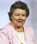
Mary Prillaman Carper
| Birth | : | 25 Dec 1921 USA |
| Death | : | 9 Jul 2010 Virginia, USA |
| Burial | : | Ingersoll Rural Cemetery, Ingersoll, Oxford County Municipality, Canada |
| Coordinate | : | 43.0545040, -80.8732690 |
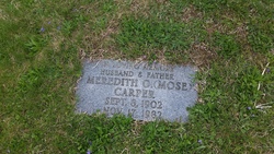
| Description | : | Mary Prillaman Carper, 88, of Roanoke, passed away Friday, July 9, 2010. Born December 25, 1921, she was a daughter of the late Maggie Philpott and George Prillaman. Mary was also preceded in death by her husband Meredith O. Carper. Mary graduated as an LPN from the Roanoke Memorial School of Nursing in 1975. She worked at every hospital in the Roanoke area, retiring from Carilion in December of 1998. Mary was a member of Virginia Heights Baptist Church. Surviving is her son Don M. Carper; her daughter, Mary Frances Carper Bowen and her husband, Gary; granddaughters, Jacqueline L. Bowen... Read More |
frequently asked questions (FAQ):
-
Where is Mary Prillaman Carper's memorial?
Mary Prillaman Carper's memorial is located at: Ingersoll Rural Cemetery, Ingersoll, Oxford County Municipality, Canada.
-
When did Mary Prillaman Carper death?
Mary Prillaman Carper death on 9 Jul 2010 in Virginia, USA
-
Where are the coordinates of the Mary Prillaman Carper's memorial?
Latitude: 43.0545040
Longitude: -80.8732690
Family Members:
Nearby Cemetories:
1. Ingersoll Rural Cemetery
Ingersoll, Oxford County Municipality, Canada
Coordinate: 43.0545040, -80.8732690
2. Sacred Heart Cemetery
Ingersoll, Oxford County Municipality, Canada
Coordinate: 43.0514300, -80.8917200
3. West Oxford United Church Cemetery
Centreville, Oxford County Municipality, Canada
Coordinate: 43.0521710, -80.8451320
4. Harris Street Cemetery
Ingersoll, Oxford County Municipality, Canada
Coordinate: 43.0175743, -80.8451233
5. Beachville Cemetery
Beachville, Oxford County Municipality, Canada
Coordinate: 43.0889511, -80.8313599
6. Red Star Cemetery
Embro, Oxford County Municipality, Canada
Coordinate: 43.1124175, -80.9326897
7. Oxford Memorial Park Cemetery
Woodstock, Oxford County Municipality, Canada
Coordinate: 43.1148200, -80.8150400
8. Saint Marys Roman Catholic Cemetery
Woodstock, Oxford County Municipality, Canada
Coordinate: 43.1089400, -80.7998900
9. Minkler Pioneer Cemetery
Zorra, Oxford County Municipality, Canada
Coordinate: 43.0139281, -80.9647896
10. Sweaburg Union Cemetery
Sweaburg, Oxford County Municipality, Canada
Coordinate: 43.0690800, -80.7623200
11. Putnam Cemetery
Putnam, Middlesex County, Canada
Coordinate: 42.9911000, -80.9538000
12. Saint Andrew’s Presbyterian Cemetery
Thamesford, Oxford County Municipality, Canada
Coordinate: 43.0615400, -80.9926700
13. Ebenezer Grove Cemetery
Mount Elgin, Oxford County Municipality, Canada
Coordinate: 42.9633100, -80.8577100
14. Wesley Methodist Cemetery
Thamesford, Oxford County Municipality, Canada
Coordinate: 43.0589380, -81.0007450
15. Banner United Cemetery
Banner, Oxford County Municipality, Canada
Coordinate: 43.0079850, -80.9849270
16. Methodist Cemetery
Embro, Oxford County Municipality, Canada
Coordinate: 43.1495018, -80.8983841
17. Old Log Church Cemetery
Embro, Oxford County Municipality, Canada
Coordinate: 43.1529121, -80.8626785
18. Hillview Cemetery
Woodstock, Oxford County Municipality, Canada
Coordinate: 43.1206703, -80.7675400
19. Scottish Pioneer
Holiday, Oxford County Municipality, Canada
Coordinate: 43.1334100, -80.9626100
20. Day Family Cemetery
Thamesford, Oxford County Municipality, Canada
Coordinate: 43.0523800, -81.0164400
21. Waggoner Pioneer Cemetery
South-West Oxford, Oxford County Municipality, Canada
Coordinate: 42.9772970, -80.7665850
22. Mount Elgin Cemetery
Mount Elgin, Oxford County Municipality, Canada
Coordinate: 42.9581400, -80.7961000
23. House of Refuge Cemetery
Woodstock, Oxford County Municipality, Canada
Coordinate: 43.1476245, -80.7873872
24. Pleasant View Cemetery
Curries, Oxford County Municipality, Canada
Coordinate: 43.0716390, -80.7196470


