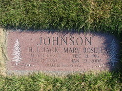
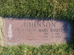
Mary Rosella Elser Williams Johnson
| Birth | : | 21 Dec 1916 |
| Death | : | 23 Jan 2007 |
| Burial | : | Winema Cemetery, Weed, Siskiyou County, USA |
| Coordinate | : | 41.4395450, -122.3817780 |
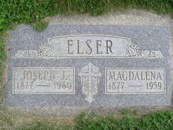
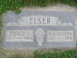
| Description | : | Wenatchee World - Jan 30, 20007 Mary Rosella Williams, 90, of Peshastin, died Tuesday morning, January 23, 2007, at her home. She was born on December 21, 1916, in Tulsa, OK to Joseph and Mary Magdelene (Fassnacht) Elser. Her parents were German/Americans and farmed near Henrietta, OK. As a young woman, Mary traveled with her friend, Mildred Wyles, to Seattle for a visit. After returning to Oklahoma, she convinced her family to leave the Dust Bowl behind and move to the Pacific Northwest. In May of 1937, Mary, her parents, her brothers, Johnnie and Justin and her sister, Freda came to Washington. With... Read More |
frequently asked questions (FAQ):
-
Where is Mary Rosella Elser Williams Johnson's memorial?
Mary Rosella Elser Williams Johnson's memorial is located at: Winema Cemetery, Weed, Siskiyou County, USA.
-
When did Mary Rosella Elser Williams Johnson death?
Mary Rosella Elser Williams Johnson death on 23 Jan 2007 in
-
Where are the coordinates of the Mary Rosella Elser Williams Johnson's memorial?
Latitude: 41.4395450
Longitude: -122.3817780
Family Members:
Parent
Spouse
Siblings
Flowers:
Nearby Cemetories:
1. Winema Cemetery
Weed, Siskiyou County, USA
Coordinate: 41.4395450, -122.3817780
2. Lincoln Heights Cemetery
Weed, Siskiyou County, USA
Coordinate: 41.4372810, -122.3899290
3. Edgewood Cemetery
Edgewood, Siskiyou County, USA
Coordinate: 41.4516330, -122.4312440
4. Arbaugh-Dunlap Cemetery
Weed, Siskiyou County, USA
Coordinate: 41.4912500, -122.4077900
5. Saint Barnabas Sacred Grounds
Mount Shasta, Siskiyou County, USA
Coordinate: 41.3201310, -122.3280340
6. Mount Shasta Memorial Park
Mount Shasta, Siskiyou County, USA
Coordinate: 41.3182983, -122.3330994
7. Foulke Cemetery
Gazelle, Siskiyou County, USA
Coordinate: 41.5144120, -122.5185930
8. Gazelle Cemetery
Siskiyou County, USA
Coordinate: 41.5133018, -122.5297012
9. Bell Cemetery
Gazelle, Siskiyou County, USA
Coordinate: 41.5082000, -122.5687300
10. Williams Cemetery
Siskiyou County, USA
Coordinate: 41.4642300, -122.6177900
11. Mott Cemetery
Mott, Siskiyou County, USA
Coordinate: 41.2607200, -122.2775500
12. Julien Cemetery
Siskiyou County, USA
Coordinate: 41.6502700, -122.5346900
13. Dunsmuir City Cemetery
Dunsmuir, Siskiyou County, USA
Coordinate: 41.2033350, -122.2748870
14. Little Shasta Cemetery
Montague, Siskiyou County, USA
Coordinate: 41.7097015, -122.3803024
15. McCloud Cemetery
McCloud, Siskiyou County, USA
Coordinate: 41.2327860, -122.1357720
16. Grave Creek Cemetery
Coffee Creek, Trinity County, USA
Coordinate: 41.2010300, -122.6459600
17. Montague Cemetery
Montague, Siskiyou County, USA
Coordinate: 41.7275009, -122.5413971
18. Conant Cemetery
Conant, Shasta County, USA
Coordinate: 41.1070700, -122.3334600
19. Tacitus Arbuckle Gravesite
Siskiyou County, USA
Coordinate: 41.3486220, -122.8116430
20. Callahan Hayden Cemetery
Callahan, Siskiyou County, USA
Coordinate: 41.3076550, -122.7945570
21. Wolford Cemetery
Siskiyou County, USA
Coordinate: 41.3806600, -122.8240100
22. Hiram Page Cemetery
Yreka, Siskiyou County, USA
Coordinate: 41.7141770, -122.6442580
23. McConaughy Burial Site
Etna, Siskiyou County, USA
Coordinate: 41.4052900, -122.8307800
24. Callahan Catholic Cemetery
Callahan, Siskiyou County, USA
Coordinate: 41.3058370, -122.7984540

