| Birth | : | 24 Nov 1936 Rockbridge County, Virginia, USA |
| Death | : | 4 May 2020 Spottswood, Augusta County, Virginia, USA |
| Burial | : | Mount Carmel Presbyterian Church Cemetery, Steeles Tavern, Augusta County, USA |
| Coordinate | : | 37.9295006, -79.1975021 |
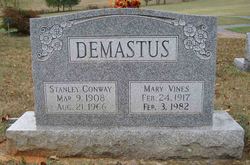
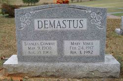
| Description | : | SPOTTSWOOD - Mary Sandra (Demastus) Patterson, 83, widow of Berl Harvey Patterson of Spottswood, died Monday, May 4, 2020, at her residence. She was born November 24, 1936, in Rockbridge County, a daughter of the late Stanley Conway and Mary (Vines) Demastus. She was a member of Mt. Carmel Presbyterian Church. Sandra was formerly employed as a secretary in the Chemistry Department of the Benger Laboratory at DuPont Company, Waynesboro. She enjoyed quilting, gardening, baking, knitting, sewing, and reading. Family members include two sons and daughters-in-law, Mark Patterson and Jennie Lewis, and Ruffner and Taysha... Read More |
frequently asked questions (FAQ):
-
Where is Mary Sandra Demastus Patterson's memorial?
Mary Sandra Demastus Patterson's memorial is located at: Mount Carmel Presbyterian Church Cemetery, Steeles Tavern, Augusta County, USA.
-
When did Mary Sandra Demastus Patterson death?
Mary Sandra Demastus Patterson death on 4 May 2020 in Spottswood, Augusta County, Virginia, USA
-
Where are the coordinates of the Mary Sandra Demastus Patterson's memorial?
Latitude: 37.9295006
Longitude: -79.1975021
Family Members:
Parent
Spouse
Siblings
Flowers:
Nearby Cemetories:
1. Mount Carmel Presbyterian Church Cemetery
Steeles Tavern, Augusta County, USA
Coordinate: 37.9295006, -79.1975021
2. Zinks Cemetery
Steeles Tavern, Augusta County, USA
Coordinate: 37.9394417, -79.1757278
3. Mount Joy Presbyterian Church Cemetery
Steeles Tavern, Augusta County, USA
Coordinate: 37.9338360, -79.1594310
4. Old Providence ARP Church Cemetery - New
Spottswood, Augusta County, USA
Coordinate: 37.9604430, -79.2256720
5. Old Providence ARP Church Cemetery
Spottswood, Augusta County, USA
Coordinate: 37.9615097, -79.2271042
6. Pines Chapel Presbyterian Church Cemetery
Greenville, Augusta County, USA
Coordinate: 37.9780800, -79.1352260
7. Mount Paran Baptist Church Cemetery
Montebello, Nelson County, USA
Coordinate: 37.8656090, -79.1472490
8. Jefferson Davis Allen Family Cemetery
Montebello, Nelson County, USA
Coordinate: 37.8839100, -79.1209100
9. Fauber Cemetery
Montebello, Nelson County, USA
Coordinate: 37.8759117, -79.1253815
10. Greenville United Methodist Church Cemetery
Greenville, Augusta County, USA
Coordinate: 38.0020700, -79.1573400
11. Dutch Hollow Cemetery
Middlebrook, Augusta County, USA
Coordinate: 38.0032038, -79.2396285
12. Greenville Baptist Church Cemetery
Greenville, Augusta County, USA
Coordinate: 38.0057000, -79.1584700
13. Greenville Cemetery
Greenville, Augusta County, USA
Coordinate: 38.0069270, -79.1553270
14. Pleas Taylor Cemetery
Montebello, Nelson County, USA
Coordinate: 37.8947220, -79.0894440
15. Thomas Campbell Cemetery
Montebello, Nelson County, USA
Coordinate: 37.8627930, -79.1097590
16. Sandy Ridge Cemetery
Montebello, Nelson County, USA
Coordinate: 37.8488998, -79.1241989
17. Grover Allen's Homeplace at Durham Run
White Rock, Nelson County, USA
Coordinate: 37.8983970, -79.0774170
18. Oakland Methodist Episcopal Cemetery
Augusta County, USA
Coordinate: 38.0311300, -79.2094600
19. Spring Valley Chapel Cemetery
Stuarts Draft, Augusta County, USA
Coordinate: 38.0025970, -79.1070320
20. Oak Hill Baptist Church Cemetery
Newport, Augusta County, USA
Coordinate: 38.0123600, -79.2812710
21. Greenmonte Fellowship Mennonite Church Cemetery
Stuarts Draft, Augusta County, USA
Coordinate: 38.0025880, -79.0920250
22. Mount Hermon Lutheran Church Cemetery
Newport, Augusta County, USA
Coordinate: 38.0018997, -79.3069000
23. Bethel Presbyterian Church Cemetery
Middlebrook, Augusta County, USA
Coordinate: 38.0425550, -79.1728310
24. Mount Airy Baptist Church Cemetery
Middlebrook, Augusta County, USA
Coordinate: 38.0448410, -79.2123350


