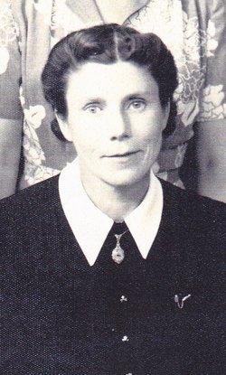
| Birth | : | 23 Dec 1870 Harrison County, Missouri, USA |
| Death | : | 4 Feb 1946 Chariton, Lucas County, Iowa, USA |
| Burial | : | Bowling Green City Cemetery, Bowling Green, Hardee County, USA |
| Coordinate | : | 27.6408815, -81.8195102 |
| Plot | : | Row 5 Grave 2 |
| Description | : | OBITUARY THE CHARITON LEADER Chariton, Iowa Tuesday, February 12, 1946 SUSIE LONG Mary Susan Wells, third daughter of Richard and Clarinda Wells, was born in Harrison county, Missouri on December 23, 1870, and departed this life at her home, 618 N. Main Street, Chariton, Iowa, on Tuesday, February 4, 1946, at the age of 75 years, one month and 12 days. She was united in marriage to Abraham Lincoln Long, of Russell, Iowa, at Bethany, Mo., on March 4, 1890. To this union eight children were born, one of whom, Lester, died in infancy. Those surviving are: Mrs. Lenora Daugherty of Chariton; Mrs. Cleora Matthews of Detroit,... Read More |
frequently asked questions (FAQ):
-
Where is Mary Susan “Susie” Wells Long's memorial?
Mary Susan “Susie” Wells Long's memorial is located at: Bowling Green City Cemetery, Bowling Green, Hardee County, USA.
-
When did Mary Susan “Susie” Wells Long death?
Mary Susan “Susie” Wells Long death on 4 Feb 1946 in Chariton, Lucas County, Iowa, USA
-
Where are the coordinates of the Mary Susan “Susie” Wells Long's memorial?
Latitude: 27.6408815
Longitude: -81.8195102
Family Members:
Parent
Spouse
Siblings
Children
Flowers:
Nearby Cemetories:
1. Bowling Green City Cemetery
Bowling Green, Hardee County, USA
Coordinate: 27.6408815, -81.8195102
2. Bowling Green Memorial Gardens
Bowling Green, Hardee County, USA
Coordinate: 27.6462710, -81.8346580
3. Paynes Creek Historic State Park Monument
Bowling Green, Hardee County, USA
Coordinate: 27.6167890, -81.8078850
4. Mount Pisgah Cemetery
Fort Meade, Polk County, USA
Coordinate: 27.6643658, -81.7913818
5. Paynes Creek Primitive Baptist Church Cemetery
Bowling Green, Hardee County, USA
Coordinate: 27.6439476, -81.8792572
6. Mount Olive Branch Cemetery
Bowling Green, Hardee County, USA
Coordinate: 27.6191998, -81.8893967
7. Lake Dale Baptist Church Cemetery
Wauchula, Hardee County, USA
Coordinate: 27.5871240, -81.7678760
8. New Hope Cemetery
Fort Meade, Polk County, USA
Coordinate: 27.7289009, -81.8367004
9. Pellum Cemetery
Polk County, USA
Coordinate: 27.6758910, -81.9168550
10. Fort Meade Cemetery
Fort Meade, Polk County, USA
Coordinate: 27.7360992, -81.8007965
11. Morrison Cemetery
Fort Meade, Polk County, USA
Coordinate: 27.7438145, -81.8047744
12. Wauchula Cemetery
Wauchula, Hardee County, USA
Coordinate: 27.5314007, -81.8116989
13. Magnolia Manor Cemetery
Wauchula, Hardee County, USA
Coordinate: 27.5294740, -81.8001560
14. Monument Park Memorial
Fort Meade, Polk County, USA
Coordinate: 27.7505170, -81.7898430
15. Hancock Cemetery
Fort Meade, Polk County, USA
Coordinate: 27.7542400, -81.8286200
16. Evergreen Cemetery
Fort Meade, Polk County, USA
Coordinate: 27.7544003, -81.7878036
17. Pleasant Grove Cemetery
Fort Meade, Polk County, USA
Coordinate: 27.7486000, -81.7656021
18. Watson Cemetery
Polk County, USA
Coordinate: 27.7487202, -81.8885727
19. Fort Green Methodist Church Cemetery
Fort Green, Hardee County, USA
Coordinate: 27.6028461, -81.9565201
20. Fort Green Baptist Church Cemetery
Fort Green, Hardee County, USA
Coordinate: 27.6006413, -81.9598541
21. New Hope Baptist Cemetery
Wauchula, Hardee County, USA
Coordinate: 27.5234910, -81.7506030
22. Hart Cemetery
Lemon Grove, Hardee County, USA
Coordinate: 27.6019001, -81.6746979
23. Old Elim Church Cemetery
Polk County, USA
Coordinate: 27.7638836, -81.8889389
24. Zolfo Springs Baptist Church Cemetery
Zolfo Springs, Hardee County, USA
Coordinate: 27.4888990, -81.7914080


