
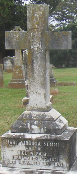
Mary Virginia Semmes Payne
| Birth | : | 18 Mar 1821 |
| Death | : | 18 Nov 1897 |
| Burial | : | Fort Steele Cemetery, Fort Steele, East Kootenay Regional District, Canada |
| Coordinate | : | 49.6260109, -115.6225662 |
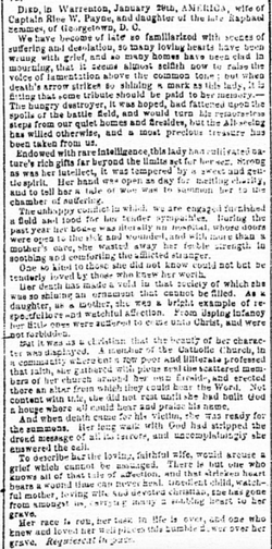
| Description | : | Sent in; Alexandria Gazette (Alexandria, D.C.) November 22, 1897 Image 2 Mrs. Rice Payne died on the 18th inst. At “Mecca,” her home, at Warrenton, in the 77th year of her age. She was the daughter of the late Raphael and Matilda Semmes, of Georgetown, D.C., and the widow of the late Major Rice W. Payne, of the Warrenton bar. Mrs. Payne was a cousin of Admiral Semmes, who commanded the Confederate States steamer “Alabama.” Mrs. Payne was buried last Saturday from the Catholic Church at Warrenton, Fathers Payne, of Staunton; Bowler, of Alexandria; Walsh, of Warrenton, and... Read More |
frequently asked questions (FAQ):
-
Where is Mary Virginia Semmes Payne's memorial?
Mary Virginia Semmes Payne's memorial is located at: Fort Steele Cemetery, Fort Steele, East Kootenay Regional District, Canada.
-
When did Mary Virginia Semmes Payne death?
Mary Virginia Semmes Payne death on 18 Nov 1897 in
-
Where are the coordinates of the Mary Virginia Semmes Payne's memorial?
Latitude: 49.6260109
Longitude: -115.6225662
Family Members:
Parent
Spouse
Siblings
Children


Nearby Cemetories:
1. Fort Steele Cemetery
Fort Steele, East Kootenay Regional District, Canada
Coordinate: 49.6260109, -115.6225662
2. Aqam Cemetery
Cranbrook, East Kootenay Regional District, Canada
Coordinate: 49.5833840, -115.7574800
3. Cranbrook Catholic Cemetery
Cranbrook, East Kootenay Regional District, Canada
Coordinate: 49.5114080, -115.7813930
4. Cranbrook Old General Cemetery
Cranbrook, East Kootenay Regional District, Canada
Coordinate: 49.5116630, -115.7826420
5. Westlawn Cemetery
Cranbrook, East Kootenay Regional District, Canada
Coordinate: 49.5112220, -115.7821910
6. Cranbrook New General Cemetery
Cranbrook, East Kootenay Regional District, Canada
Coordinate: 49.5118890, -115.7837250
7. Marysville Cemetery
Marysville, East Kootenay Regional District, Canada
Coordinate: 49.6386900, -115.9513300
8. Kimberley Cemetery
Kimberley, East Kootenay Regional District, Canada
Coordinate: 49.6766700, -115.9746000
9. Sand Creek Cemetery
Jaffray, East Kootenay Regional District, Canada
Coordinate: 49.3362250, -115.2909390
10. Moyie Cemetery
Moyie, East Kootenay Regional District, Canada
Coordinate: 49.2743920, -115.8350350
11. Fernie Cemetery
Fernie, East Kootenay Regional District, Canada
Coordinate: 49.5002240, -115.0579050
12. East Fernie Cemetery
Fernie, East Kootenay Regional District, Canada
Coordinate: 49.5018590, -115.0566640
13. Saint Margaret's Cemetery
Fernie, East Kootenay Regional District, Canada
Coordinate: 49.4989900, -115.0550900
14. Hosmer Cemetery
Hosmer, East Kootenay Regional District, Canada
Coordinate: 49.5863580, -114.9565980
15. Elko Cemetery
Elko, East Kootenay Regional District, Canada
Coordinate: 49.2978200, -115.1353500
16. Baynes Lake Cemetery
Baynes Lake, East Kootenay Regional District, Canada
Coordinate: 49.2369900, -115.2106000
17. Morrissey Cemetery
Morrissey, East Kootenay Regional District, Canada
Coordinate: 49.3751030, -114.9941990
18. Hannah Robinson Gravesite
Morrissey, East Kootenay Regional District, Canada
Coordinate: 49.3725000, -114.9913800
19. Rivercrest Cemetery
Sparwood, East Kootenay Regional District, Canada
Coordinate: 49.7617300, -114.8862200
20. Elk Valley Cemetery
Sparwood, East Kootenay Regional District, Canada
Coordinate: 49.7403800, -114.8685100
21. Canal Flats Cemetery
Canal Flats, East Kootenay Regional District, Canada
Coordinate: 50.1617820, -115.8049420
22. Yahk Cemetery
Yahk, Central Kootenay Regional District, Canada
Coordinate: 49.0885510, -116.0776230
23. Corbin Cemetery
Corbin, East Kootenay Regional District, Canada
Coordinate: 49.5217700, -114.6785500
24. Mountview Cemetery
Elkford, East Kootenay Regional District, Canada
Coordinate: 50.0583600, -114.9222300