
Mary Wood Platt
| Birth | : | 10 Nov 1605 Roydon, Epping Forest District, Essex, England |
| Death | : | 24 Jan 1675 Milford, New Haven County, Connecticut, USA |
| Burial | : | Grantville Cemetery, Grantville, Bass Coast Shire, Australia |
| Coordinate | : | -38.3947460, 145.5398240 |
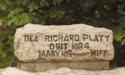
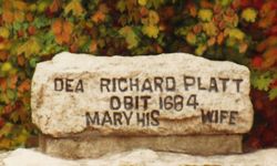
| Description | : | The daughter of John & Jane Wood of Roydon, Co. Essex, England. She was baptized on November 10th 1605 in Roydon, Co. Essex, England. Richard Platt and Mary Wood were married on 26 January 1628/1629 in Roydon. On 25 April 1638, Richard & Mary sold their property in Ware (which is four miles southeast of Roydon) in England, and prepared to sail to New England. The family was first at New Haven and by 1640 were in Milford (lot #38 West Main and Cherry Street). Mary joined the Milford church on 29 January 1639/40 the same... Read More |
frequently asked questions (FAQ):
-
Where is Mary Wood Platt's memorial?
Mary Wood Platt's memorial is located at: Grantville Cemetery, Grantville, Bass Coast Shire, Australia.
-
When did Mary Wood Platt death?
Mary Wood Platt death on 24 Jan 1675 in Milford, New Haven County, Connecticut, USA
-
Where are the coordinates of the Mary Wood Platt's memorial?
Latitude: -38.3947460
Longitude: 145.5398240
Family Members:
Spouse

Children

Flowers:


Nearby Cemetories:
1. Grantville Cemetery
Grantville, Bass Coast Shire, Australia
Coordinate: -38.3947460, 145.5398240
2. Corinella Cemetery
Corinella, Bass Coast Shire, Australia
Coordinate: -38.4361780, 145.4847240
3. Nyora Cemetery
Nyora, South Gippsland Shire, Australia
Coordinate: -38.3406970, 145.6637270
4. Lang Lang Cemetery
Lang Lang, Cardinia Shire, Australia
Coordinate: -38.2779980, 145.5831970
5. Kilcunda Cemetery
Kilcunda, Bass Coast Shire, Australia
Coordinate: -38.5590700, 145.4918990
6. Poowong Cemetery
Poowong, South Gippsland Shire, Australia
Coordinate: -38.3461002, 145.7615830
7. San Remo Cemetery
San Remo, Bass Coast Shire, Australia
Coordinate: -38.5264220, 145.3794970
8. San Remo Fisherman Lost at Sea
San Remo, Bass Coast Shire, Australia
Coordinate: -38.5204271, 145.3646088
9. Outtrim Cemetery
Outtrim, South Gippsland Shire, Australia
Coordinate: -38.5122130, 145.7768440
10. Tooradin Christ Church Memorial Garden
Tooradin, Casey City, Australia
Coordinate: -38.2109390, 145.3781320
11. Wonthaggi Cemetery
Wonthaggi, Bass Coast Shire, Australia
Coordinate: -38.6211128, 145.5833282
12. Phillip Island Cemetery
Cowes, Bass Coast Shire, Australia
Coordinate: -38.4703860, 145.2578930
13. Coal Creek Community Park and Museum
Korumburra, South Gippsland Shire, Australia
Coordinate: -38.4438019, 145.8312988
14. Korumburra Cemetery
Korumburra, South Gippsland Shire, Australia
Coordinate: -38.4303000, 145.8482100
15. Ripplebrook Cemetery
Drouin South, Baw Baw Shire, Australia
Coordinate: -38.2074990, 145.7508310
16. Hmas Cerberus Cemetery
Crib Point, Mornington Peninsula Shire, Australia
Coordinate: -38.3740200, 145.2103850
17. Tyabb Cemetery
Hastings, Mornington Peninsula Shire, Australia
Coordinate: -38.3029320, 145.2141720
18. Inverloch Cemetery
Inverloch, Bass Coast Shire, Australia
Coordinate: -38.6273780, 145.7185850
19. Crib Point Cemetery
Crib Point, Mornington Peninsula Shire, Australia
Coordinate: -38.3540390, 145.1879580
20. Captain Grossard Lone Grave
Ventnor, Bass Coast Shire, Australia
Coordinate: -38.4625830, 145.1785719
21. Leongatha Cemetery
Leongatha, South Gippsland Shire, Australia
Coordinate: -38.4831187, 145.9380932
22. Bunyip Cemetery
Bunyip, Cardinia Shire, Australia
Coordinate: -38.0838160, 145.7169040
23. Pakenham Cemetery
Pakenham, Cardinia Shire, Australia
Coordinate: -38.0561540, 145.4513150
24. Cranbourne Cemetery
Cranbourne, Casey City, Australia
Coordinate: -38.1118510, 145.2728020