
| Birth | : | 17 Oct 1939 Alley Spring, Shannon County, Missouri, USA |
| Death | : | 3 Apr 2013 Missouri, USA |
| Burial | : | Oak Forest Cemetery, Birch Tree, Shannon County, USA |
| Coordinate | : | 36.9818993, -91.4847031 |
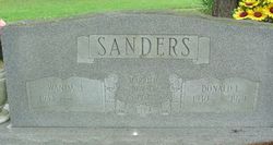
| Description | : | Mavis Irene Cook the daughter of Walter F. Sanders and Gladys (Younger) Sanders was born at Alley Springs, Missouri October 17, 1939, and went to her Heavenly home Wednesday night, April 3, 2013 after a lengthy illness making her age 73 years 5 months 16 days. Mavis was united in marriage to John Charles, to their union one daughter Sharon was born. After his death Mavis married Bill D. Cook, September 16, 1983. She was a previous member of the Church of God of Prophecy in Eminence, Missouri. She was baptized by Rev. Bud Younger while attending there. She enjoyed big family... Read More |
frequently asked questions (FAQ):
-
Where is Mavis Irene Sanders Cook's memorial?
Mavis Irene Sanders Cook's memorial is located at: Oak Forest Cemetery, Birch Tree, Shannon County, USA.
-
When did Mavis Irene Sanders Cook death?
Mavis Irene Sanders Cook death on 3 Apr 2013 in Missouri, USA
-
Where are the coordinates of the Mavis Irene Sanders Cook's memorial?
Latitude: 36.9818993
Longitude: -91.4847031
Family Members:
Parent
Spouse
Siblings


Flowers:


Nearby Cemetories:
1. Oak Forest Cemetery
Birch Tree, Shannon County, USA
Coordinate: 36.9818993, -91.4847031
2. Warm Corners Cemetery
Birch Tree, Shannon County, USA
Coordinate: 36.9653015, -91.4880981
3. Brown-DePriest Cemetery
Birch Tree, Shannon County, USA
Coordinate: 36.9674988, -91.5000000
4. Old Baptist Cemetery
Birch Tree, Shannon County, USA
Coordinate: 36.9798775, -91.5186768
5. Oak Grove Cemetery
Birch Tree, Shannon County, USA
Coordinate: 36.9632111, -91.4445267
6. Berea Mennonite Cemetery
Birch Tree, Shannon County, USA
Coordinate: 37.0246010, -91.5110016
7. Dunkard Cemetery
Montier, Shannon County, USA
Coordinate: 37.0208015, -91.5580978
8. Montier Cemetery
Montier, Shannon County, USA
Coordinate: 36.9847984, -91.5754013
9. Cooper Cemetery
Winona, Shannon County, USA
Coordinate: 36.9681168, -91.3861847
10. Lindsey Cemetery
Winona, Shannon County, USA
Coordinate: 36.9793701, -91.3825531
11. Turkey Oak Cemetery
Montier, Shannon County, USA
Coordinate: 37.0203018, -91.5768967
12. Williams Cemetery
Shannon County, USA
Coordinate: 36.9617996, -91.3778000
13. Corinth Cemetery
Birch Tree, Shannon County, USA
Coordinate: 36.9169998, -91.5661011
14. Barnes Cemetery
Birch Tree, Shannon County, USA
Coordinate: 36.9178009, -91.3822021
15. Pleasant Grove Cemetery
Teresita, Shannon County, USA
Coordinate: 36.9742012, -91.6206970
16. New Salem Cemetery
Teresita, Shannon County, USA
Coordinate: 36.9239006, -91.6027985
17. Martin Barnes Cemetery
Birch Tree, Shannon County, USA
Coordinate: 36.9140000, -91.3740000
18. Bethlehem Cemetery
Thomasville, Oregon County, USA
Coordinate: 36.8861389, -91.5680008
19. Baptist Hill Cemetery
Winona, Shannon County, USA
Coordinate: 37.0059013, -91.3330994
20. Rader Cemetery
Eminence, Shannon County, USA
Coordinate: 37.0999985, -91.4060974
21. Delaware Cemetery
Eminence, Shannon County, USA
Coordinate: 37.1032982, -91.4092026
22. Pine Lawn Cemetery
Winona, Shannon County, USA
Coordinate: 37.0078011, -91.3181000
23. Ledbetter Cemetery
Spring Creek, Oregon County, USA
Coordinate: 36.8566080, -91.5501210
24. Pilgrim Rest Cemetery
Teresita, Shannon County, USA
Coordinate: 37.0189018, -91.6485977