
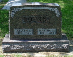
Melven Jacob “Bud” Bourn
| Birth | : | 9 Mar 1908 Niobrara, Knox County, Nebraska, USA |
| Death | : | 13 Sep 1994 Creighton, Knox County, Nebraska, USA |
| Burial | : | L'Eau Qui Court Cemetery, Niobrara, Knox County, USA |
| Coordinate | : | 42.7458000, -98.0231018 |
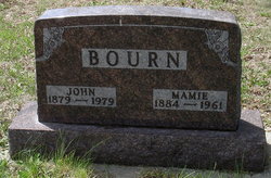
| Description | : | A memorial service for Melven J. Bourn, 86, of Niobrara was held, Saturday, September 17, 1994 at Niobrara Lutheran Church with Rev. Mark Liscom officiating. Burial was in L'Eau Qui Court in Niobrara. Melven Jacob Bourn was born March 9, 1908 to John and Mamie Blankenfeld Bourn in Niobrara, NE. He attended rural school and worked on the family far. On Sept. 9, 1932, he married Martha A. Juracek. Two daughter were born to them, Betty Jean and Janice May. The couple farmed in the Niobrara area. He also trucked. Martha passed away December 9, 1952. On June 19, 1954, Melven married Hazel Witt,... Read More |
frequently asked questions (FAQ):
-
Where is Melven Jacob “Bud” Bourn's memorial?
Melven Jacob “Bud” Bourn's memorial is located at: L'Eau Qui Court Cemetery, Niobrara, Knox County, USA.
-
When did Melven Jacob “Bud” Bourn death?
Melven Jacob “Bud” Bourn death on 13 Sep 1994 in Creighton, Knox County, Nebraska, USA
-
Where are the coordinates of the Melven Jacob “Bud” Bourn's memorial?
Latitude: 42.7458000
Longitude: -98.0231018
Family Members:
Parent

Spouse

Siblings
Children
Flowers:


Nearby Cemetories:
1. L'Eau Qui Court Cemetery
Niobrara, Knox County, USA
Coordinate: 42.7458000, -98.0231018
2. Mormon Monument
Ponca, Knox County, USA
Coordinate: 42.7443000, -98.0632500
3. Ponka Tribal Cemetery
Knox County, USA
Coordinate: 42.7122700, -98.0830000
4. Bazile Creek Cemetery
Bazile Mills, Knox County, USA
Coordinate: 42.7377500, -97.9311500
5. Emanuel Cemetery
Springfield, Bon Homme County, USA
Coordinate: 42.8400002, -97.9903030
6. Kurka Family Cemetery
Dukesville, Knox County, USA
Coordinate: 42.6918000, -98.1374000
7. Ponca Evangelical Lutheran Cemetery
Niobrara, Knox County, USA
Coordinate: 42.7428000, -98.1621000
8. Riverview Cemetery
Knox County, USA
Coordinate: 42.7322006, -98.1619034
9. Pioneer Cemetery
Springfield, Bon Homme County, USA
Coordinate: 42.8513985, -98.0500031
10. Hillcrest Cemetery
Verdigre, Knox County, USA
Coordinate: 42.6356010, -98.0378036
11. Pleasant Hill Cemetery
Verdigre, Knox County, USA
Coordinate: 42.6837500, -98.1619500
12. Bethlehem Lutheran Cemetery
Springfield, Bon Homme County, USA
Coordinate: 42.8727989, -98.0494003
13. Saint Wenceslaus Cemetery
Verdigre, Knox County, USA
Coordinate: 42.6039009, -98.0428009
14. Riverside Cemetery
Verdigre, Knox County, USA
Coordinate: 42.6011009, -98.0286026
15. Ponca Valley Cemetery
Verdel, Knox County, USA
Coordinate: 42.8135000, -98.1990000
16. Springfield Cemetery
Springfield, Bon Homme County, USA
Coordinate: 42.8732986, -97.9132996
17. Saint Vincents Cemetery
Springfield, Bon Homme County, USA
Coordinate: 42.8744011, -97.9132996
18. Congregational Cemetery
Santee, Knox County, USA
Coordinate: 42.8330000, -97.8523000
19. Friedensberg Mennonite Cemetery
Avon, Bon Homme County, USA
Coordinate: 42.8958015, -98.0667038
20. Bohemian National Cemetery
Knox County, USA
Coordinate: 42.6178017, -98.1483002
21. Santee Mission Cemetery
Knox County, USA
Coordinate: 42.8408000, -97.8378200
22. Howe Creek Cemetery
Lindy, Knox County, USA
Coordinate: 42.6810000, -97.8127000
23. National Cemetery
Pishelville, Knox County, USA
Coordinate: 42.7190000, -98.2500000
24. Santee Catholic Cemetery
Santee, Knox County, USA
Coordinate: 42.8373000, -97.8287400