
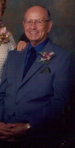
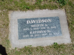
Melvin Archie Davidson
| Birth | : | 7 Sep 1907 The Dalles, Wasco County, Oregon, USA |
| Death | : | 19 Feb 2000 Springfield, Lane County, Oregon, USA |
| Burial | : | New Ponce de Leon Cemetery, Ponce de Leon, Holmes County, USA |
| Coordinate | : | 30.7325001, -85.9460983 |
| Description | : | The Dalles Chronicle, February 22, 2000: Mel Davidson, 92, a former three-term mayor of The Dalles, during construction of the Dalles Dam, died in Springfield of Feb. 19, 2000. He had lived in Springfield since 1971. He was born in The Dalles and owned the Associated Oil Distributorship, Tire and Recap Shop and The Dalles Natural Gas Company, which he sold to Northwest Natural Gas Company, and then managed the company. At the time of his death he had been a Shaklee Supervisor since 1968 and had recently expanded his business to the internet. For... Read More |
frequently asked questions (FAQ):
-
Where is Melvin Archie Davidson's memorial?
Melvin Archie Davidson's memorial is located at: New Ponce de Leon Cemetery, Ponce de Leon, Holmes County, USA.
-
When did Melvin Archie Davidson death?
Melvin Archie Davidson death on 19 Feb 2000 in Springfield, Lane County, Oregon, USA
-
Where are the coordinates of the Melvin Archie Davidson's memorial?
Latitude: 30.7325001
Longitude: -85.9460983
Family Members:
Flowers:


Nearby Cemetories:
1. New Ponce de Leon Cemetery
Ponce de Leon, Holmes County, USA
Coordinate: 30.7325001, -85.9460983
2. Old Ponce de Leon Cemetery
Ponce de Leon, Holmes County, USA
Coordinate: 30.7219000, -85.9367000
3. Oak Grove Cemetery
Ponce de Leon, Holmes County, USA
Coordinate: 30.7464970, -85.9026520
4. Otter Creek Methodist Church Cemetery
Ponce de Leon, Holmes County, USA
Coordinate: 30.7784200, -85.9539300
5. Saint Pauls Cemetery
Walton County, USA
Coordinate: 30.6825864, -85.9403855
6. Old Mount Zion Cemetery
Westville, Holmes County, USA
Coordinate: 30.7220400, -85.8833040
7. Floyd-Bowers Family Cemetery
Knox Hill, Walton County, USA
Coordinate: 30.6580600, -85.9166100
8. Westville Cemetery
Westville, Holmes County, USA
Coordinate: 30.7632999, -85.8593979
9. Resurrection Ground Cemetery
Argyle, Walton County, USA
Coordinate: 30.7242160, -86.0457280
10. Corinth Cemetery
Prosperity, Holmes County, USA
Coordinate: 30.8188900, -85.9694300
11. Hickory Hill Baptist Church Cemetery
Westville, Holmes County, USA
Coordinate: 30.8224888, -85.9305954
12. Pleasant Grove Presbyterian Church Cemetery
Walton County, USA
Coordinate: 30.6534653, -86.0016174
13. Euchee Valley Cemetery
Eucheeanna, Walton County, USA
Coordinate: 30.6537170, -86.0032196
14. Sandy Creek Cemetery
Ponce de Leon, Holmes County, USA
Coordinate: 30.8109300, -86.0131600
15. John Braxton Cemetery
Westville, Holmes County, USA
Coordinate: 30.8177840, -85.8800537
16. Campground Cemetery
Westville, Holmes County, USA
Coordinate: 30.8215010, -85.8805560
17. Evergreen Missionary Baptist Church Cemetery
Westville, Holmes County, USA
Coordinate: 30.8243500, -85.8845100
18. Currington Family Cemetery
Ponce de Leon, Holmes County, USA
Coordinate: 30.6260880, -85.9711230
19. Parish Cemetery
Ponce de Leon, Holmes County, USA
Coordinate: 30.8100670, -86.0369000
20. New Bethany Assembly of God Cemetery
Washington County, USA
Coordinate: 30.6642900, -85.8429600
21. Unity Baptist Church Cemetery
Vernon, Washington County, USA
Coordinate: 30.6387600, -85.8725300
22. Pleasant Grove United Methodist Church Cemetery
Hinsons Crossroads, Washington County, USA
Coordinate: 30.6579690, -85.8432668
23. Robert L Jones Cemetery
Westville, Holmes County, USA
Coordinate: 30.8405381, -85.8921500
24. Burke's Memorial Gardens
Vernon, Washington County, USA
Coordinate: 30.6288800, -85.8757000