
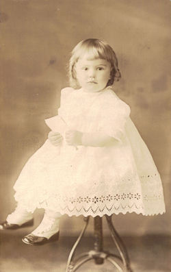

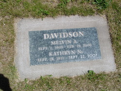
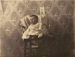
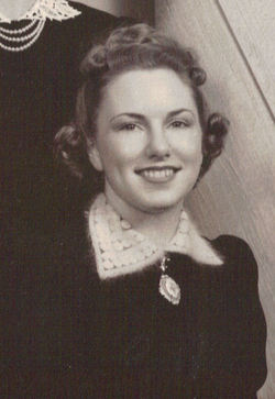
Kathryn Naomi Crooks Davidson
| Birth | : | 28 Sep 1911 Goldendale, Klickitat County, Washington, USA |
| Death | : | 22 Sep 2007 West Linn, Clackamas County, Oregon, USA |
| Burial | : | Boonsboro Cemetery, Boonsboro, Washington County, USA |
| Coordinate | : | 39.5045100, -77.6524700 |
| Plot | : | Block Section 13 Lot 6 Space 4 |
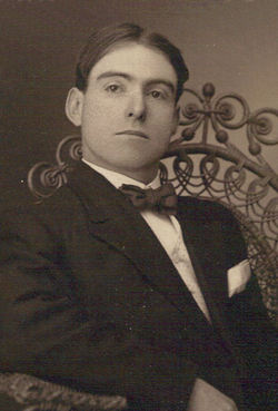
| Description | : | The Register-Guard, October 2, 2007: A memorial graveside service will be held at 1 p.m. Oct. 20 in Mountain View Cemetery in Goldendale, Wash., for Kathryn N. Davidson of West Linn, formerly of Springfield. She died Sept. 22 of age-related causes at age 95. She was born Sept. 28, 1911, in Goldendale to Carl and Anna Hamilton Crooks. She married Melvin Davidson on April 17, 1931, in Goldendale. She graduated from Goldendale High School and attended business college. She was a homemaker. Survivors include a son, Edwin of Springfield; a daughter, Kathy Davidson Altig of West Linn; six grandchildren and eight... Read More |
frequently asked questions (FAQ):
-
Where is Kathryn Naomi Crooks Davidson's memorial?
Kathryn Naomi Crooks Davidson's memorial is located at: Boonsboro Cemetery, Boonsboro, Washington County, USA.
-
When did Kathryn Naomi Crooks Davidson death?
Kathryn Naomi Crooks Davidson death on 22 Sep 2007 in West Linn, Clackamas County, Oregon, USA
-
Where are the coordinates of the Kathryn Naomi Crooks Davidson's memorial?
Latitude: 39.5045100
Longitude: -77.6524700
Family Members:
Parent
Spouse

Siblings
Flowers:


Nearby Cemetories:
1. Boonsboro Cemetery
Boonsboro, Washington County, USA
Coordinate: 39.5045100, -77.6524700
2. Trinity Reformed United Church of Christ Cemetery
Boonsboro, Washington County, USA
Coordinate: 39.5058300, -77.6542800
3. Old Salem Church Cemetery
Boonsboro, Washington County, USA
Coordinate: 39.5062590, -77.6543710
4. Abraham Lemaster Gravesite
Boonsboro, Washington County, USA
Coordinate: 39.5084763, -77.6521835
5. Zittlestown Church of God Cemetery
Zittlestown, Washington County, USA
Coordinate: 39.4878300, -77.6269200
6. Mount Carmel Church Cemetery
Keedysville, Washington County, USA
Coordinate: 39.4724998, -77.6564026
7. Mount Hebron Cemetery
Keedysville, Washington County, USA
Coordinate: 39.4824982, -77.6900024
8. Snyder Farm Cemetery
Boonsboro, Washington County, USA
Coordinate: 39.4641300, -77.6618000
9. Fairview Cemetery
Keedysville, Washington County, USA
Coordinate: 39.4882200, -77.7023600
10. Benevola United Methodist Church Cemetery
Benevola, Washington County, USA
Coordinate: 39.5452000, -77.6745000
11. Mount Zion Mennonite Church Cemetery
Mapleville, Washington County, USA
Coordinate: 39.5525017, -77.6530991
12. Red Hill Cemetery
Keedysville, Washington County, USA
Coordinate: 39.4700100, -77.6989400
13. Mount Tabor Church Cemetery
Frostown, Frederick County, USA
Coordinate: 39.4795900, -77.5889800
14. Mount Zion Lutheran Church Cemetery
Locust Grove, Washington County, USA
Coordinate: 39.4478760, -77.6637726
15. Jerusalem Cemetery
Jerusalem, Frederick County, USA
Coordinate: 39.5235200, -77.5796600
16. Mount Lena United Brethren Church Graveyard
Mount Lena, Washington County, USA
Coordinate: 39.5624313, -77.6319504
17. Manor Church of the Brethren Cemetery
Tilghmanton, Washington County, USA
Coordinate: 39.5285988, -77.7264023
18. Pleasant Walk United Methodist Church Cemetery
Myersville, Frederick County, USA
Coordinate: 39.5426200, -77.5856300
19. Emmert Graveyard
Tilghmanton, Washington County, USA
Coordinate: 39.5265850, -77.7306050
20. Mount Zion United Methodist Church Cemetery
Myersville, Frederick County, USA
Coordinate: 39.5127983, -77.5686035
21. Saint Pauls Lutheran Church Cemetery
Myersville, Frederick County, USA
Coordinate: 39.5072600, -77.5672600
22. Mount Briar Cemetery
Washington County, USA
Coordinate: 39.4427986, -77.6864014
23. Rohrersville Cemetery
Rohrersville, Washington County, USA
Coordinate: 39.4333000, -77.6619034
24. Locust Valley First Church of God Cemetery
Middletown, Frederick County, USA
Coordinate: 39.4346000, -77.6269800